
California, Oregon, and Washington Could Face a High-Impact Pacific Storm as Models Signal Dangerous Conditions December 23–24
SAN FRANCISCO, CALIFORNIA — Weather models are increasingly converging on a potentially high-impact Pacific storm that could affect large portions of California, Oregon, and Washington between December 23 and December 24, just ahead of Christmas Eve. Forecasters say confidence is growing as multiple model runs now align with what long-range guidance has been signaling for several days.
The developing system has the hallmarks of a powerful, dynamic storm, capable of producing widespread impacts from heavy precipitation to strong winds across the West Coast.
Forecast Models Shift Toward a Stronger Storm Scenario
Recent evening model runs show a pronounced trend toward storm intensification, particularly in upper-level dynamics. Forecast imagery highlights a deep trough diving southward from the Pacific, helping to energize the system as it approaches the coast.
Meteorologists note that global guidance, including the ECMWF, has remained consistent in showing a potent setup, and other models are now moving into closer agreement. This growing consensus raises confidence that the storm could bring significant weather impacts rather than a weaker, fast-moving system.
Storm Track Could Impact Much of the West Coast
If current projections hold, the storm would span a wide geographic area, with impacts extending from California northward through Oregon and into Washington State. Such a broad footprint suggests that multiple hazards may occur simultaneously across different regions.
In California, the storm could deliver heavy rainfall, particularly along coastal and mountainous areas already sensitive to runoff. Oregon and Washington may face a combination of strong winds, heavy rain, and mountain snow, depending on elevation and timing.
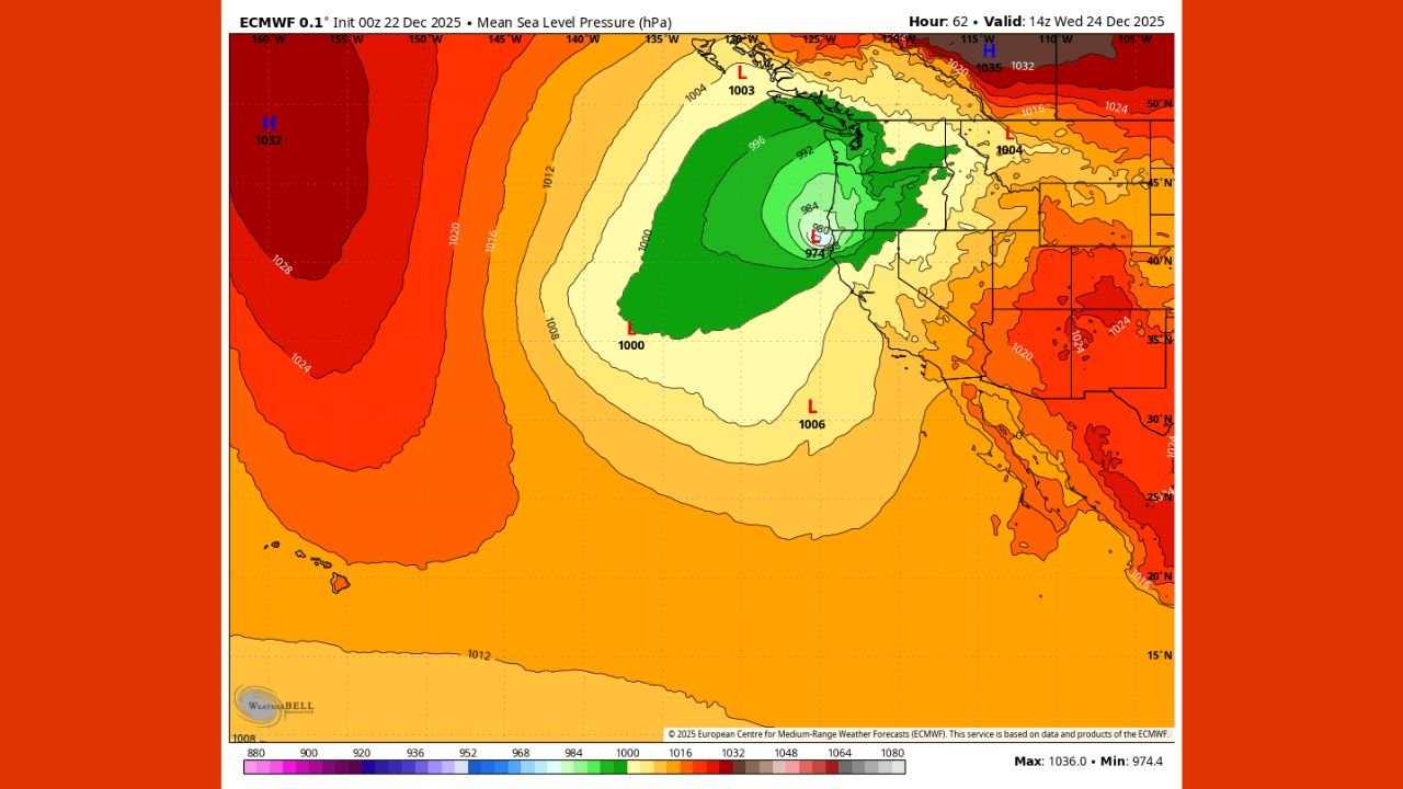
Pressure Patterns Signal Powerful Winds
Mean sea-level pressure forecasts show a deepening low-pressure system offshore, surrounded by tightly packed pressure gradients. This setup is often associated with strong, potentially damaging wind gusts, especially along exposed coastlines and higher terrain.
Forecasters caution that if the pressure gradients tighten further, wind impacts could become a primary concern, including downed trees, power outages, and hazardous travel conditions during one of the busiest weeks of the year.
Timing Near Christmas Raises Travel Concerns
The projected December 23–24 timing places the storm squarely during peak holiday travel. Even modest shifts in timing or intensity could significantly affect road, air, and marine travel across the West Coast.
Emergency planners are closely monitoring the evolution of the system, as early messaging and preparedness may be necessary if confidence continues to increase in a high-impact outcome.
What Remains Uncertain
While the overall signal for a strong storm is becoming clearer, important details are still being refined. These include:
- Exact landfall location
- Duration of peak impacts
- Rainfall and wind intensity by region
Small changes in the storm’s track could shift the highest impacts north or south, altering which communities experience the worst conditions.
Residents Urged to Monitor Forecast Updates
Meteorologists emphasize that this is a developing situation, but the increasing model agreement is a strong indicator that residents across California, Oregon, and Washington should stay alert.
With additional data expected in the next 24 hours, clearer guidance on impacts and potential warnings should emerge soon.
As the West Coast approaches a critical forecast window ahead of Christmas, staying informed will be essential. For continued updates on this developing storm system and other major weather events, visit ChicagoMusicGuide.com.