
California Storm System Set to Drench Central and Northern Regions With Heavy Rain and Scattered Thunderstorms February 10–12
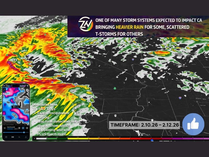
LOS ANGELES, CALIFORNIA — One of several incoming storm systems is expected to impact California between February 10 and February 12, bringing a swath of moderate to heavy rain across portions of the state. Forecast data shows the most active dynamics favoring Central California and areas north of Los Angeles, while San Diego County appears likely to see lighter totals with this particular system. The broader pattern remains active, signaling that this is just one round in a series of systems moving through the West.
Central California Braces for Heavier Rain Bands
Radar and model projections indicate the heaviest rainfall stretching across Central California, including areas north of Los Angeles County. The setup supports pockets of locally heavy rain, particularly where terrain enhancement and upslope flow increase totals.
Northern portions of Southern California, especially counties just north of Los Angeles, could experience stronger rainfall rates as instability increases. Embedded heavier bands may develop within the broader rain shield, raising the risk for localized flooding.
Periods of moderate to heavy rain are expected, especially during peak forcing. Travel conditions could deteriorate quickly under heavier cells.
Thunderstorm Risk Greatest North of Los Angeles
Forecast discussions highlight scattered thunderstorm potential, particularly from Los Angeles northern counties northward into Central California. Atmospheric dynamics and instability appear stronger in those regions compared to areas farther south.
While severe weather is not explicitly indicated, thunderstorms may produce brief downpours capable of reducing visibility and creating slick road conditions. Drivers traveling along major corridors through Central California should prepare for sudden heavy bursts of rain.
Localized ponding of water on roadways and minor flooding in poor drainage areas are possible, especially where heavier cells repeatedly track over the same location.
Terrain and Upslope Areas Could See Enhanced Totals
Enhanced rainfall near higher terrain and upslope-favored zones is likely. Mountain and foothill communities may see higher accumulations compared to surrounding valleys.
Runoff concerns could increase where rain rates intensify. Residents in hillside communities should remain alert to changing conditions, particularly during peak rainfall periods.
Reduced visibility and slick travel conditions are expected during heavier bands, especially along major transportation routes through Central and Southern California.
Southern California Sees Lower-End Impacts
While Los Angeles County northward faces stronger impacts, San Diego County appears positioned on the lower end of totals with this specific system. Forecast guidance suggests less than one inch of rain for most areas in San Diego County during this timeframe.
However, the active pattern does not end with this storm. Additional systems are expected beyond February 12, meaning Southern California may still see more opportunities for rain in the coming days.
Timing and Broader Pattern
The main window for this storm runs from February 10 through February 12, with rain spreading north to south as the system progresses. Thunderstorm chances will likely peak during periods of strongest forcing, primarily north of Los Angeles.
Forecasters also note that Arizona is not expected to see major impacts from this particular system, though subsequent systems in the broader pattern could bring additional weather concerns, including potential snow in higher elevations later in the cycle.
California’s active February pattern continues to deliver meaningful precipitation, particularly for Central and northern portions of the state. Residents should monitor local updates as rainfall intensity and thunderstorm placement become clearer.
As multiple systems line up to impact the West Coast, staying informed will be key. For continued national weather updates and how changing conditions could affect travel, festivals, and live events across the country, visit ChicagoMusicGuide.com.