
California, Texas, Arizona and Nevada Brace for Intense Heat Surge While New York and New England Turn Cooler in Late March Temperature Split
UNITED STATES — A dramatic weather divide is setting up across the country as a powerful upper-level ridge prepares to deliver widespread above-normal temperatures across the western and southern United States, while cooler-than-normal air lingers over the Northeast.
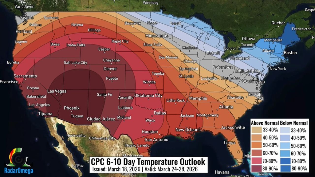
The latest 6–10 day temperature outlook (March 24–28) highlights a clear split, with intense warmth dominating from California to Texas, contrasted by chilly conditions across New York and New England.
West and Southwest Facing Strong Heat Anomaly
The most significant heat is expected across:
- California (including Los Angeles and Central Valley regions)
- Nevada (Las Vegas)
- Arizona (Phoenix, Tucson)
- Utah and western Colorado
These areas are under the highest probability zone—70% to 90% chance of above-normal temperatures, signaling a strong and persistent ridge of high pressure.
Cities like Phoenix, Las Vegas, and Los Angeles could see temperatures climbing well above seasonal averages, potentially feeling more like early summer than late March.
Southern Plains and Gulf States Also Heating Up
The warmth doesn’t stop in the West. It extends deep into:
- Texas (Dallas, Houston, San Antonio)
- Oklahoma (Oklahoma City)
- Louisiana and Mississippi
- Alabama and Georgia
These regions are forecast to see 50% to 70% probabilities of above-normal temperatures, indicating a broad and expanding heat zone stretching from the Southwest into the Deep South.
Midwest Sees Transition Zone Including Illinois and Missouri
The central U.S., including:
- Illinois (Chicago, Springfield)
- Missouri (St. Louis)
- Indiana and Kentucky
will sit in a transition zone, where temperatures are still expected to be slightly above normal, but not as extreme as the western states.
This means cities like Chicago may experience mild to warm conditions, especially compared to average late-March temperatures.
Northeast and Great Lakes Turn Cooler Than Normal
In contrast, the outlook shows cooler-than-average temperatures across:
- New York (including NYC)
- Massachusetts (Boston)
- Pennsylvania and New Jersey
- Upstate New York and New England states
These areas fall into the blue-shaded zone, indicating 33% to 60% probability of below-normal temperatures.
The cooling trend is being driven by a persistent trough over eastern Canada and the Northeast, allowing colder air to filter southward.
Why This Temperature Split Is Happening
Meteorologists point to a classic atmospheric setup:
- A strong ridge of high pressure in the West, trapping heat and promoting clear skies
- A trough over eastern Canada and the Northeast, funneling cooler air southward
- A sharp boundary between these systems creating a coast-to-coast temperature contrast
This pattern is typical during seasonal transitions but can still produce significant regional impacts.
What This Means for Late March Weather
This setup could lead to:
- Early-season heat concerns in the Southwest and Southern Plains
- Increased energy demand for cooling in warmer regions
- Continued chilly mornings and below-average conditions in the Northeast
The contrast between regions may also enhance storm development along the boundary zone, particularly across the Midwest.
A Nation Split Between Summer-Like Heat and Lingering Chill
As the final week of March approaches, the United States is preparing for a two-season scenario, where one half of the country warms rapidly while the other remains stuck in cooler conditions.
From California and Texas heating up significantly to New York and New England cooling down, this pattern highlights the dynamic nature of spring weather across the nation.
Stay with ChicagoMusicGuide.com for continued updates on national weather patterns and temperature trends impacting communities across the United States.