
California, Washington, the Midwest, and the Southeast Set to Experience Classic La Niña Winter Patterns With Colder North, Wetter West, and Drier South Across the United States
UNITED STATES — NOAA’s La Niña Map Reveals How This Winter May Impact Weather Across Multiple Regions
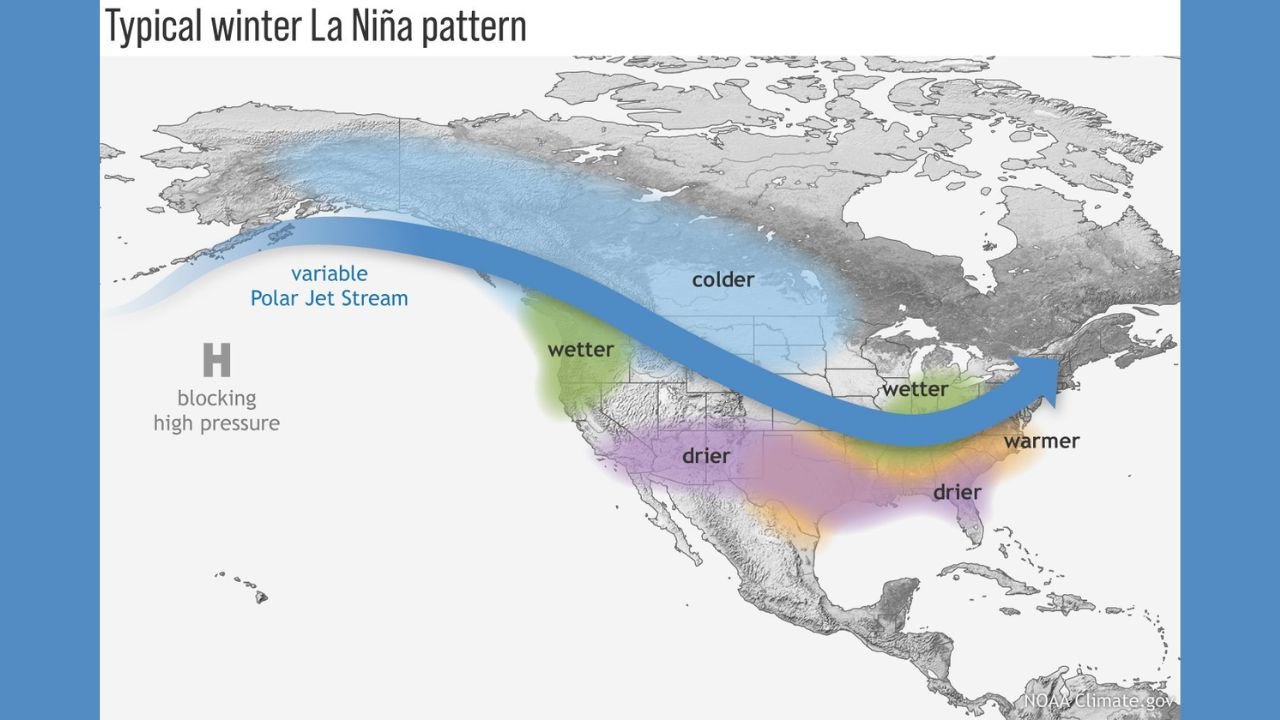
A newly released NOAA climate graphic illustrates how La Niña is expected to shape the U.S. winter weather pattern, affecting millions of Americans from the Pacific Northwest to the Southeast. La Niña, a cooling of Pacific Ocean waters near the equator, often shifts the position of the jet stream, creating distinct cold, warm, wet, and dry zones across the country.
The visual outlines the familiar pattern:
- A colder-than-normal winter for much of the northern United States
- Wetter conditions in the Pacific Northwest and Ohio Valley
- Drier, warmer weather across the southern tier, including California, Texas, and the Southeast
- A variable, active jet stream that can influence storm tracks across central and eastern states
Meteorologists rely on this pattern each year to anticipate how storms, temperature swings, and precipitation may behave during the peak winter months of December through February.
Pacific Northwest: Washington & Oregon Expected to See Wetter, Stormier Conditions
According to the La Niña pattern, Washington and Oregon are positioned beneath the strongest Pacific moisture flow. This typically brings:
- More frequent rain events
- Higher mountain snowfall
- Stronger coastal storms
- Occasional flooding concerns in river basins
La Niña winters are historically beneficial for mountain snowpack, an important resource for spring water supplies.
California: Wetter North, Drier South Under Split Jet Stream
California often experiences divided impacts during La Niña:
- Northern California may see slightly wetter conditions thanks to the northern jet stream
- Southern California falls into the “drier-than-normal” zone
- Snow levels may vary widely depending on storm tracks
This pattern can worsen drought conditions in the southern half of the state.
Northern Plains & Midwest: Minnesota, Wisconsin, Michigan, Illinois Facing Colder-than-Normal Winter
The coldest anomalies during La Niña typically affect Minnesota, Wisconsin, Michigan, Iowa, and parts of Illinois. The graphic shows a strong cold pool stretching across the northern tier of the country.
Residents in these states can expect:
- Increased Arctic air intrusions
- More frequent cold snaps
- Higher chances for below-zero wind chills
- Occasional Alberta Clipper snow events
This colder setup also increases the chances of lake-effect snow, particularly around Lakes Michigan and Superior.
Ohio Valley & Great Lakes: Wetter Winter for Ohio, Indiana, Kentucky
The map highlights Ohio, Indiana, and Kentucky in a “wetter-than-normal” zone. This usually translates to:
- More frequent storm systems
- Potential for rain-snow mix events
- Elevated chances for regional flooding
- Enhanced winter storm tracks when cold air is present
This region often becomes a battleground between warm southern air and cold northern air, creating messy winter storms.
Southern U.S.: Texas, Louisiana, Mississippi, Alabama, Georgia Expected to Be Drier and Warmer
The southern tier of the U.S. experiences some of the most noticeable effects of La Niña. According to NOAA’s pattern:
- Texas, Louisiana, Mississippi, Alabama, Georgia, and Florida typically see warmer and drier winters
- Severe drought risk increases in southern Texas and the Gulf Coast
- Fewer large winter storms impact this region
Warm anomalies may also increase the number of early-season severe weather setups in late winter.
Mid-Atlantic & Southeast Coast: Virginia and the Carolinas Trending Warmer
States such as Virginia, North Carolina, and South Carolina generally experience:
- Milder winter temperatures
- Reduced snowfall chances
- Occasional intrusions of cold air but fewer long-lasting freezes
Storms that do form often track too far north to deliver significant winter precipitation.
What This Means for the United States as a Whole
This La Niña winter setup suggests:
- More cold outbreaks across the northern U.S.
- Increased storminess in the Great Lakes and Pacific Northwest
- Reduced rainfall and snowfall across southern states
- Heightened risk of drought expansion in the Southwest and Gulf Coast
- Potential for high-impact winter storms depending on how the jet stream shifts in January
While La Niña patterns are generally reliable, local conditions can still vary dramatically based on short-term temperature swings or individual storm tracks.
Stay connected with ChicagoMusicGuide.com for continuing winter coverage, regional climate updates, and the latest U.S. weather trends throughout the season.