
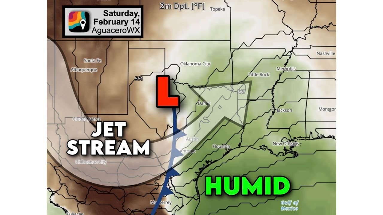
Central and East Texas Face Valentine’s Day Severe Weather Risk as Jet Stream Trough and Gulf Humidity Align Along I-35 Corridor
DALLAS, TEXAS — Early signs are pointing toward a potential severe weather setup on Saturday, February 14, across central and east Texas, particularly along and east of the Interstate 35 corridor. Forecast guidance shows an approaching upper-air disturbance carving a trough into the southern United States, while warm, humid air surges north from the Gulf of Mexico.
This developing pattern could support thunderstorms capable of producing damaging wind gusts, with at least a low-end risk for an isolated brief tornado. Portions of Louisiana and possibly southwest Arkansas may also come into play depending on how the system evolves.
Jet Stream Trough Setting the Stage
Upper-level analysis indicates a pronounced dip in the jet stream — commonly referred to as a trough — moving into west Texas and the southern Plains. This feature enhances lift and strengthens winds aloft, creating favorable conditions for organized storm development.
As the trough approaches, surface low pressure is expected to deepen across Texas. Ahead of it, southerly winds will draw humid Gulf air northward into central and eastern parts of the state.
This interaction between strengthening jet energy aloft and increasing low-level moisture is a key ingredient for storm intensification.
Humidity and Instability Building East of I-35
Dew point projections show richer moisture pooling across Austin, Dallas, Houston, and east Texas communities, with the most favorable environment appearing along and east of I-35.
The combination of warm surface temperatures and increasing humidity will create instability — essentially fuel for thunderstorms. Showers and thunderstorms are expected to develop along the advancing frontal boundary during the day Saturday.
While it remains too early to define exact storm coverage, atmospheric signals suggest at least a few storms could organize enough to produce strong wind gusts.
Damaging Winds Possible, Isolated Spin-Up Cannot Be Ruled Out
Given the influx of jet stream energy, storms may be able to transfer stronger winds from aloft down to the surface. That raises the potential for localized damaging wind gusts.
At this stage, forecasters are cautious about any tornado threat. However, with sufficient wind shear in place, an isolated, brief spin-up cannot be ruled out — especially within stronger storm cells embedded in a larger rain shield.
The most likely timeframe for stronger activity appears to be during the afternoon and evening hours on Saturday, February 14, though adjustments are possible as newer data refines timing.
Louisiana and Southwest Arkansas May Join the Risk Area
As the system progresses eastward, western and northern Louisiana could experience similar conditions. Portions of southwest Arkansas may also see increasing instability if moisture pushes farther north than currently projected.
The exact northern extent of the severe corridor will depend on how quickly Gulf moisture advances and how the surface low tracks.
What Residents Should Expect
For communities in:
- Dallas–Fort Worth
- Austin and San Antonio
- Houston and southeast Texas
- Western Louisiana
Saturday may feature rounds of showers and thunderstorms, with a few stronger cells capable of producing gusty winds.
Residents should stay weather-aware, especially if planning outdoor Valentine’s Day activities or travel.
Forecast details will continue to sharpen as high-resolution guidance refines storm structure and timing. Even small shifts in track can alter where the strongest storms form.
For continued updates on severe weather patterns affecting weekend travel, live events, and regional schedules across the country, stay connected with ChicagoMusicGuide.com for the latest coverage.