
Central Texas and the Hill Country Face Isolated Flash Flood Risk as Rain Rates Near 2 Inches Per Hour Develop Overnight
CENTRAL TEXAS — Portions of Central Texas and the Texas Hill Country are facing a growing risk of isolated flash flooding late Friday night into early Saturday as localized, slow-moving heavy rain develops along a stalled boundary. Meteorological analysis shows rainfall rates approaching 1 to 2 inches per hour, which could overwhelm drainage systems in a short period of time, especially in flood-prone areas.
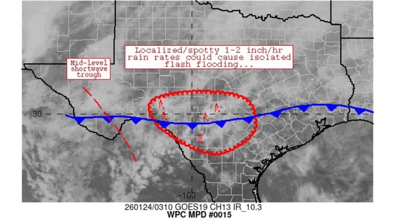
Localized Heavy Rain Developing Across Central Texas
Weather pattern analysis indicates that a mid-level shortwave trough moving into the region is enhancing lift across Central Texas, allowing showers and thunderstorms to become more efficient rain producers. Rather than widespread rainfall, the concern is spotty but intense downpours forming over the same areas.
This type of setup favors localized flooding, where some communities may see minimal impacts while others experience rapid water accumulation within a short window.
Rainfall Rates Could Reach 1–2 Inches Per Hour
The most significant threat comes from rainfall intensity, not storm coverage. Forecast guidance shows that individual storm cells may produce rainfall rates of 1 to 2 inches per hour, which is sufficient to cause flash flooding in urban areas, low-lying roads, and locations with poor drainage.
Because storms may repeatedly move over the same locations, even brief periods of heavy rain could lead to rapid rises in water levels on streets and creeks.
Why the Hill Country Is Especially Vulnerable
The Texas Hill Country is particularly susceptible to flash flooding due to its rocky terrain, shallow soils, and rapid runoff characteristics. Water can move quickly into creeks and low crossings, sometimes with little warning.
Even areas that have not seen recent heavy rain can flood quickly when rainfall rates are high, making nighttime flooding especially dangerous.
Flooding May Develop Quickly Overnight
Forecasters caution that flooding may occur before warnings can be issued, especially if heavy rainfall develops suddenly. Nighttime conditions increase the risk, as drivers may not recognize flooded roadways until it is too late.
Low-water crossings, rural roads, and urban streets with poor drainage are expected to be the first locations impacted if rainfall rates increase as projected.
What Central Texas Residents Should Do
Residents across Central Texas and the Hill Country are advised to take the following precautions overnight:
- Avoid driving through water-covered roads
- Monitor local weather alerts closely
- Be especially cautious in flood-prone areas
- Have alternate routes planned if traveling early Saturday
Even shallow floodwaters can be dangerous, particularly at night when visibility is limited.
As Central Texas and the Hill Country monitor this evolving heavy rain threat, situational awareness will be critical to staying safe. For continued updates on rainfall intensity, flash flood risks, and overnight weather impacts, visit ChicagoMusicGuide.com for the latest coverage.