
Chicago, Detroit and Cleveland Now Face a Slight Risk of Severe Weather This Tuesday With Damaging Winds, Large Hail and a Tornado Threat Expected During the Afternoon and Evening Hours
CHICAGO, IL — The severe weather threat for Tuesday just got upgraded — and if you live anywhere near Chicago, Detroit or Cleveland, this is the alert you need to see right now. The Storm Prediction Center has officially added a Slight Risk of severe weather to Tuesday’s forecast for a core zone covering the southern Great Lakes region. Damaging winds, large hail and a low but real tornado threat are all expected during the afternoon and evening hours — and there is an additional factor making this event more dangerous than a typical spring storm day for this region.
What a Slight Risk Actually Means for Your Tuesday
When the Storm Prediction Center issues a Slight Risk, it means organized severe thunderstorms are expected. This is not the lowest category on the scale — that would be a Marginal Risk. A Slight Risk means the forecasters are confident enough in the setup to expect multiple severe weather reports across the highlighted area during the valid time period.
For Tuesday, that means residents inside the yellow and green zones on the outlook map should treat this as a real threat that requires situational awareness throughout the afternoon and evening — not a forecast to glance at and forget.
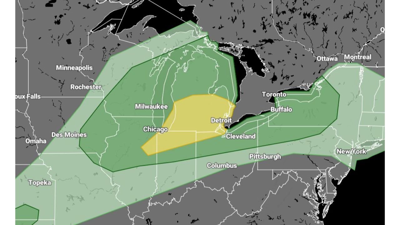
The Two Zones on the Map and What They Mean
The Tuesday outlook map shows two distinct shaded areas across the Great Lakes region — and understanding what each one means for your specific location is the most important piece of information in this entire forecast.
The yellow zone — Slight Risk covers the highest-confidence severe weather area for Tuesday. This zone is centered over Chicago, Milwaukee, Detroit and Cleveland, extending from northern Illinois and Indiana northeast through Lower Michigan and into the Buffalo corridor. This is where organized severe thunderstorm activity is most likely during the afternoon and evening hours. If you live in this corridor, Tuesday afternoon demands your full attention.
The green zone — Marginal Risk surrounds the yellow Slight Risk area and covers a much broader geographic footprint. It extends from Omaha and Des Moines in the west all the way northeast through Minneapolis, the Upper Peninsula of Michigan and into upstate New York and the New England border. This zone carries a lower but still real severe weather threat — storms are possible but less organized and less certain than in the yellow core.
The Extra Danger Factor: Saturated Soils and Recent Storm History
Here is what makes Tuesday’s threat more impactful than a typical late-March severe weather event for this region — and it is something that does not show up on any weather map.
This area has been hit by multiple storm systems throughout March. Repeated rounds of rainfall have left soils across Illinois, Indiana, Michigan and Ohio significantly saturated. When soils are already waterlogged, tree roots lose their grip on the ground. Trees that would survive a 60 mph wind gust on dry, firm soil can topple in gusts that would otherwise be considered survivable.
This means damaging winds on Tuesday carry a heightened tree-down risk across the entire Slight and Marginal Risk zones — even in areas where wind gusts may be on the lower end of the severe threshold. Power outages, road blockages and structural damage from falling trees are all elevated concerns for Tuesday’s event compared to what the raw wind numbers alone would suggest.
Tuesday Severe Weather Threat Summary Table
| Zone | Cities Included | Primary Threats | Timing | Risk Level |
|---|---|---|---|---|
| Slight Risk — Yellow | Chicago, Milwaukee, Detroit, Cleveland | Damaging winds, large hail, low tornado | Afternoon into evening | 🟡 Slight |
| Marginal Risk — Green | Minneapolis, Omaha, Buffalo, Columbus | Damaging winds, isolated hail | Afternoon into evening | 🟢 Marginal |
| Saturated Soil Factor | IL, IN, MI, OH | Enhanced tree damage risk | All day | ⚠️ Elevated |
| Forecast Confidence | SPC Official Slight Risk | Organized storms expected | Tuesday PM | 🟡 Moderate-High |
Where Each State Stands for Tuesday
🟡 Illinois — Chicago metro, Rockford, Joliet — Sitting inside the Slight Risk yellow zone. The Chicago metro is directly in the highest-confidence severe weather corridor for Tuesday. Damaging wind gusts are the primary threat for the city and suburbs, with large hail possible with any organized supercell that fires ahead of the main line.
🟡 Michigan — Detroit, Lansing, Grand Rapids, Kalamazoo — The entire Lower Peninsula from the Indiana border north through Detroit falls inside or immediately adjacent to the yellow Slight Risk zone. Detroit faces the highest combined threat of any Michigan city in this outlook. Tuesday afternoon into evening is the critical window.
🟡 Ohio — Cleveland, Toledo, Akron — The northeastern Ohio corridor sits on the eastern edge of the yellow zone. Cleveland and the Lake Erie shoreline are inside the Slight Risk area. Damaging winds along the lake corridor are the primary concern.
🟡 Indiana — Gary, South Bend, Fort Wayne — Northern Indiana falls inside the yellow Slight Risk zone. The Gary-South Bend corridor is in the direct path of storms tracking northeast out of Illinois on Tuesday afternoon.
🟢 Wisconsin — Milwaukee, Madison — Milwaukee sits on the northern edge of the yellow zone. Slight Risk conditions apply for the Milwaukee metro. Madison is inside the broader green Marginal Risk area.
🟢 Minnesota — Minneapolis, Rochester — Inside the green Marginal Risk zone. Severe weather possible but less organized than the core Great Lakes threat area.
🟢 Iowa — Des Moines, Omaha border area — Western edge of the green zone. Marginal severe weather threat — damaging wind gusts the primary concern if storms reach this far west.
🟢 New York — Buffalo, Rochester — Eastern edge of the green zone. Storms tracking northeast could reach western New York by Tuesday evening with damaging wind potential.
What You Need to Do Before Tuesday Afternoon
If you live in the Chicago, Detroit or Cleveland corridor — the most important action you can take right now is simple. Get any large, dead or visibly stressed trees near your home assessed before Tuesday if at all possible. With saturated soils already in place, Tuesday is not the day to hope that big oak in the backyard holds up. If you cannot get a tree professional out before Tuesday, at minimum park vehicles away from large trees during the afternoon and evening hours.
Make sure weather alerts are active on every phone in your household before you leave for work Tuesday morning. The afternoon severe weather window can move fast — storms that initiate over Illinois can reach the Detroit area in a matter of hours.
Know the difference between a Severe Thunderstorm Watch — conditions are favorable, stay alert — and a Severe Thunderstorm Warning — a severe storm is occurring or imminent in your area, take immediate action.
The Great Lakes Severe Weather Season Has Officially Opened for Business This Tuesday
More storm systems are lined up behind Tuesday across Illinois, Michigan and Ohio. Stay informed at ChicagoMusicGuide.com — your source for daily severe weather upgrades, SPC risk level tracking and storm alerts across Chicago, Detroit, Cleveland and the entire United States.