
Chicago, Detroit and New York City in Expanding Winter Storm Threat Sunday Into Monday With Heavy Snow and Ice Possible
CHICAGO, ILLINOIS — A developing winter storm could impact large portions of the Midwest and Northeast from Sunday into Monday, bringing the potential for heavy snow, impactful ice, and significant travel disruptions. Forecast confidence is increasing in a broad zone of wintry precipitation, although exact snowfall totals and the rain-versus-snow line remain uncertain.
Major metro areas potentially in the path include Chicago, Detroit, Indianapolis, Cleveland, Pittsburgh, New York City, and Boston, where shifts in storm track could determine whether conditions turn plowable or messy.
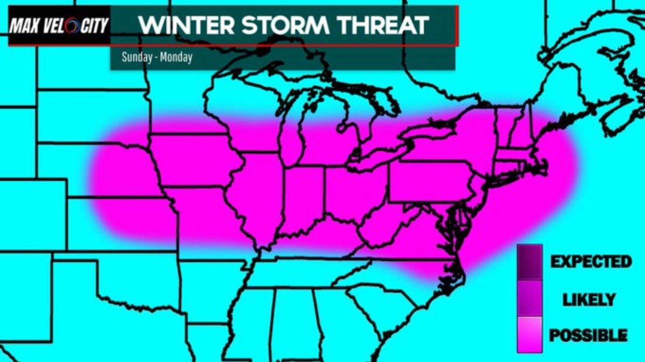
Broad Swath of Wintry Precipitation Emerging
The current winter storm threat map highlights a wide corridor stretching from:
- Iowa and northern Illinois
- Across Indiana and Michigan
- Through Ohio and Pennsylvania
- Into New York and New England
Within this zone, heavy snow appears likely in some locations, while others could see mixed precipitation or freezing rain depending on temperature profiles.
The system’s size suggests impacts will not be isolated, with a multi-state footprint spanning the Great Lakes into the Northeast.
Chicago and Great Lakes Region in the Mix
Chicago sits within the highlighted threat zone, with the potential for:
- Accumulating snowfall
- Periods of sleet or freezing rain
- Gusty winds
The precise track of the low-pressure system will determine how much cold air remains in place over northern Illinois. A slight northward shift could introduce more mixing, while a more southerly track would favor heavier snow totals.
Detroit and Cleveland face similar uncertainty, as lake influences and boundary placement could affect precipitation type and intensity.
Ice and Snow Concerns in the Ohio Valley and Mid-Atlantic
Cities such as Indianapolis, Pittsburgh, and Columbus could experience a transition zone scenario, where snow changes to sleet or freezing rain during peak storm intensity.
Farther east, New York City and Boston are also within the potential impact corridor. While coastal areas often deal with rain-to-snow transitions in March storms, colder inland regions could see steadier snowfall.
If heavier bands develop overhead, localized higher totals are possible across interior Pennsylvania and upstate New York.
Travel Disruptions Possible
With the storm expected to move through from Sunday into Monday, the timing raises concern for:
- Sunday evening travel
- Monday morning commutes
- Flight delays at major airports
Major hubs including O’Hare International Airport in Chicago, Detroit Metro Airport, and LaGuardia and Logan airports in the Northeast could face weather-related delays if heavier snow or icing materializes.
Road conditions may deteriorate quickly where heavier bands set up.
Storm Track Remains the Key Variable
Forecasters emphasize that the exact path and strength of the system will determine who sees:
- Plowable snow
- A disruptive ice event
- A mix of rain and snow
- Minimal impacts
Small shifts in track can dramatically change totals across the Midwest and Northeast. Forecast details are expected to sharpen within the next 24 to 48 hours as higher-resolution data becomes available.
Confidence Growing, Details Still Refining
While uncertainty remains in exact accumulation amounts, confidence is increasing that a significant area of wintry weather will develop somewhere across the Midwest and Northeast.
Residents across Illinois, Michigan, Indiana, Ohio, Pennsylvania, New York, and Massachusetts should monitor forecast updates closely as the event approaches.
As Sunday draws closer, preparedness will be critical across Chicago and the broader Great Lakes region. For continued updates on winter storm timing, snowfall projections, and travel impacts, visit ChicagoMusicGuide.com.