
Chicago, St. Louis, Indianapolis and Washington D.C. in Expanding Plains-to-Mid-Atlantic Winter Impact Zone Sunday Through Tuesday
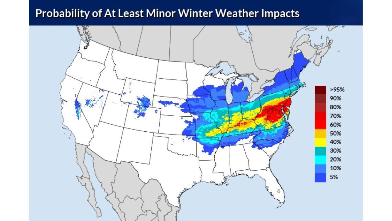
UNITED STATES — A broad swath of winter weather impacts is increasingly likely from the Central Plains through the Midwest and into the Mid-Atlantic Sunday into Tuesday, with probability maps showing at least minor impacts affecting cities including St. Louis, Chicago, Indianapolis, Columbus, Pittsburgh, Washington D.C., Baltimore and Philadelphia.
The latest National Weather Service probability guidance highlights two key windows:
- Sunday into Monday morning (March 1–2)
- Monday into Tuesday morning (March 2–3)
And confidence is growing that wintry precipitation will stretch from Missouri and Illinois eastward through Ohio, Pennsylvania and into the Mid-Atlantic states.
Sunday Into Monday: Midwest and Ohio Valley Focus
For the Sunday–Monday timeframe, probabilities for at least minor winter weather impacts increase across:
- Missouri
- Illinois
- Indiana
- Ohio
- Kentucky
- West Virginia
- Into parts of Pennsylvania
Cities such as St. Louis, Chicago, Indianapolis and Columbus sit within a zone of elevated probabilities, particularly along a corridor of yellow and orange shading that suggests a higher likelihood of travel impacts.
This period appears centered across the Midwest and Ohio Valley, where accumulating snow or mixed precipitation could lead to slick roads and reduced visibility.
Monday Into Tuesday: Mid-Atlantic Risk Intensifies
By Monday into Tuesday morning, the focus shifts eastward.
Higher impact probabilities expand across:
- Eastern Ohio
- Pennsylvania
- Maryland
- Virginia
- Washington D.C.
- Delaware
- Southern New Jersey
The most intense probabilities (red shading on the map) are centered from western Virginia through Maryland and into southern Pennsylvania, indicating a stronger potential for impactful winter conditions in those areas.
Major metro areas including Washington D.C., Baltimore and Philadelphia could see the highest risk of disruptive weather during this second phase.
Chicago and Illinois: On the Northern Edge
Chicago and much of northern Illinois remain within the broader impact zone during the Sunday–Monday period, though probabilities appear somewhat lower compared to the core band farther south.
Still, even minor winter impacts can:
- Disrupt Sunday evening travel
- Affect Monday morning commutes
- Cause localized flight delays at major hubs such as O’Hare
Residents in Illinois should monitor forecast updates as small shifts in storm track could alter snowfall intensity or precipitation type.
Plains to Mid-Atlantic Swath
The overall picture shows a classic late-winter setup:
A storm system tracking from the Central Plains through the Midwest and into the Mid-Atlantic, spreading snow and mixed precipitation across a wide corridor.
States potentially affected include:
- Missouri
- Illinois
- Indiana
- Ohio
- Kentucky
- West Virginia
- Pennsylvania
- Maryland
- Virginia
- New Jersey
Confidence is highest in a broad area of minor impacts, with pockets of more significant disruption possible — especially east of the Appalachians during the Monday–Tuesday period.
What to Watch
Key factors that will determine impact severity include:
- Exact storm track
- Rain versus snow line placement
- Timing of heavier bands
- Surface temperature profiles
As we move closer to Sunday, forecast details will sharpen and more precise snowfall projections will become available.
Bottom Line
Winter weather looks increasingly likely from St. Louis and Chicago to Washington D.C. and Philadelphia between Sunday and Tuesday morning.
Even where totals remain modest, travel disruptions are possible across the Midwest and Mid-Atlantic.
For continuing updates on timing, snowfall potential and Midwest impacts, stay with ChicagoMusicGuide.com.