
Coastal Storm Trends Offshore, Limiting Snow for Southern New England While Nantucket Faces Strongest Impacts Sunday
SOUTHERN NEW ENGLAND — A developing coastal storm expected Sunday has trended farther offshore, significantly reducing snowfall impacts for much of southern New England. Forecast guidance shows the best chance for measurable snow now focused on Nantucket, with Cape Cod and Martha’s Vineyard likely to see lighter but still impactful accumulations. Strong winds will remain a major concern across coastal areas regardless of snowfall totals.
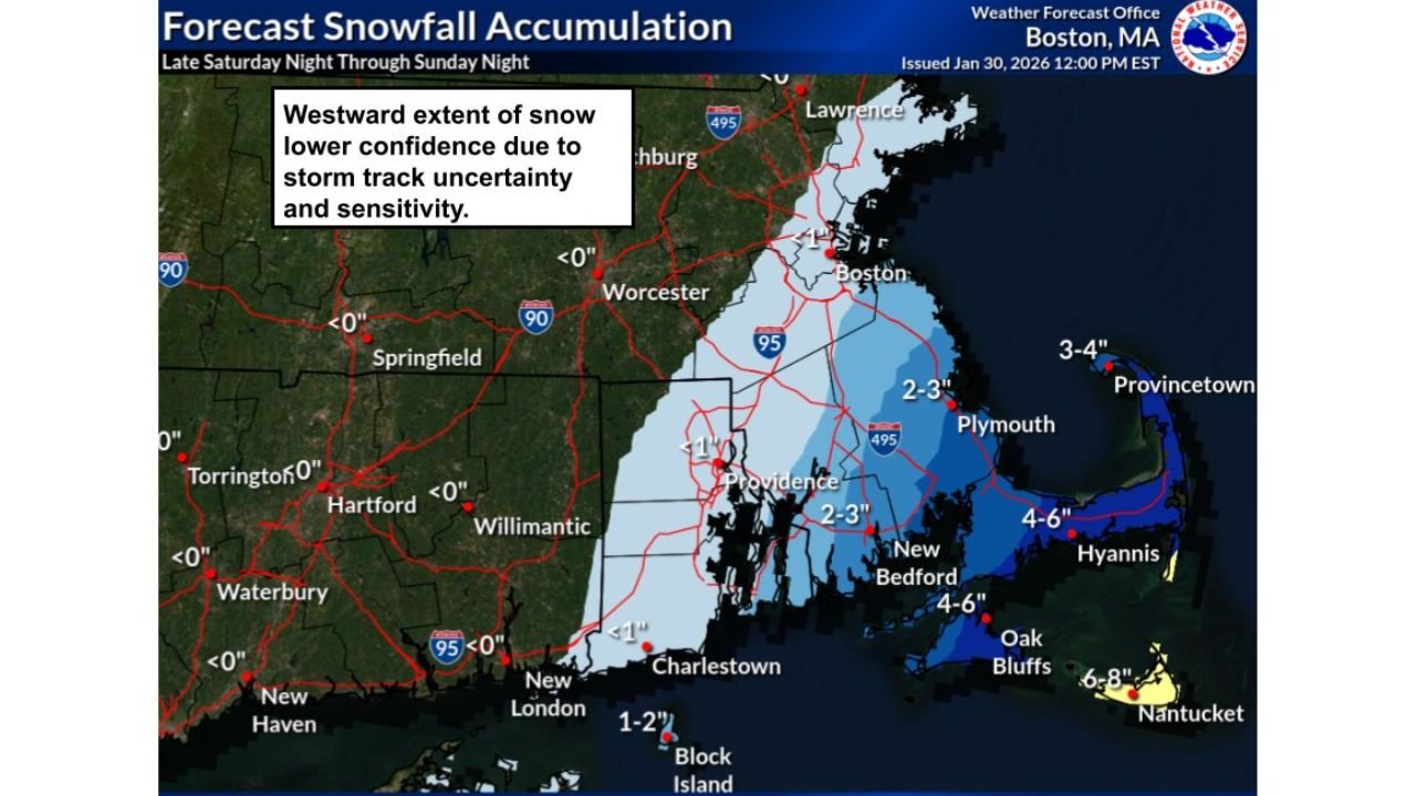
Storm Track Shifts Offshore, Reducing Inland Snowfall
Updated National Weather Service guidance shows the storm’s core energy staying east of the coastline, limiting how far west snowfall can spread. As a result, most inland areas across Massachusetts, Connecticut, and Rhode Island are expected to see little to no accumulation.
Forecasters note that the westward extent of snow remains uncertain, with confidence lower due to the storm’s sensitivity to small track changes. Even a slight shift back toward the coast could increase totals, but current trends favor a mostly offshore system.
Nantucket Most Likely to See Accumulating Snow
Among all locations, Nantucket has the highest probability of appreciable snowfall, with forecast totals in the 6 to 8 inch range possible by late Sunday. Snowfall rates may increase during the day Sunday as bands pivot across the island.
Cape Cod and Martha’s Vineyard are close behind, with projected accumulations generally in the 2 to 6 inch range, depending on exact placement of snow bands. Outer Cape communities stand the best chance for higher totals, while areas closer to Buzzards Bay may see lighter amounts.
Timing Confidence High, Amounts Less Certain
Forecast confidence is high regarding timing but medium for snowfall totals. Snow is expected to arrive very early Sunday morning, shortly after midnight, with the steadiest snowfall occurring during the daytime hours.
Snow should taper Sunday evening, lingering the longest across the Cape and Islands. Inland locations may only see brief flurries or light snow showers before the system pulls away.
Strong Winds Pose Additional Hazards
Even where snowfall remains limited, wind impacts will be significant. Forecasts call for gusts between 30 and 50 mph, especially along exposed coastal areas.
These strong winds could lead to:
- Reduced visibility during periods of snow
- Blowing and drifting snow on Nantucket and the Outer Cape
- Difficult travel conditions, particularly on bridges and causeways
Marine conditions are also expected to deteriorate rapidly, with hazardous seas and gale-force gusts possible offshore.
Travel Impacts Most Likely on the Cape and Islands
Travel confidence remains medium, with the greatest disruptions expected on Cape Cod, Martha’s Vineyard, and Nantucket. Snow-covered roads, strong crosswinds, and low visibility could make travel difficult at times on Sunday.
Farther inland, impacts should be minimal, though coastal commuters should remain alert for rapidly changing conditions if snow bands shift unexpectedly.
As southern New England monitors this evolving coastal system, forecasters emphasize that small track changes still matter, particularly for communities closest to the ocean. For continued updates on winter storms, regional forecasts, and coastal impacts across the Northeast, visit ChicagoMusicGuide.com.