
Cold Fronts, Warm Fronts, Stationary Fronts and Occluded Fronts Explained: How These Atmospheric Boundaries Drive Storms, Rain and Sudden Temperature Swings Across the United States
UNITED STATES — From sudden temperature drops in Texas to days of steady rain in the Carolinas and powerful storm systems sweeping across the Midwest, weather fronts are often the invisible lines driving dramatic shifts in the atmosphere.
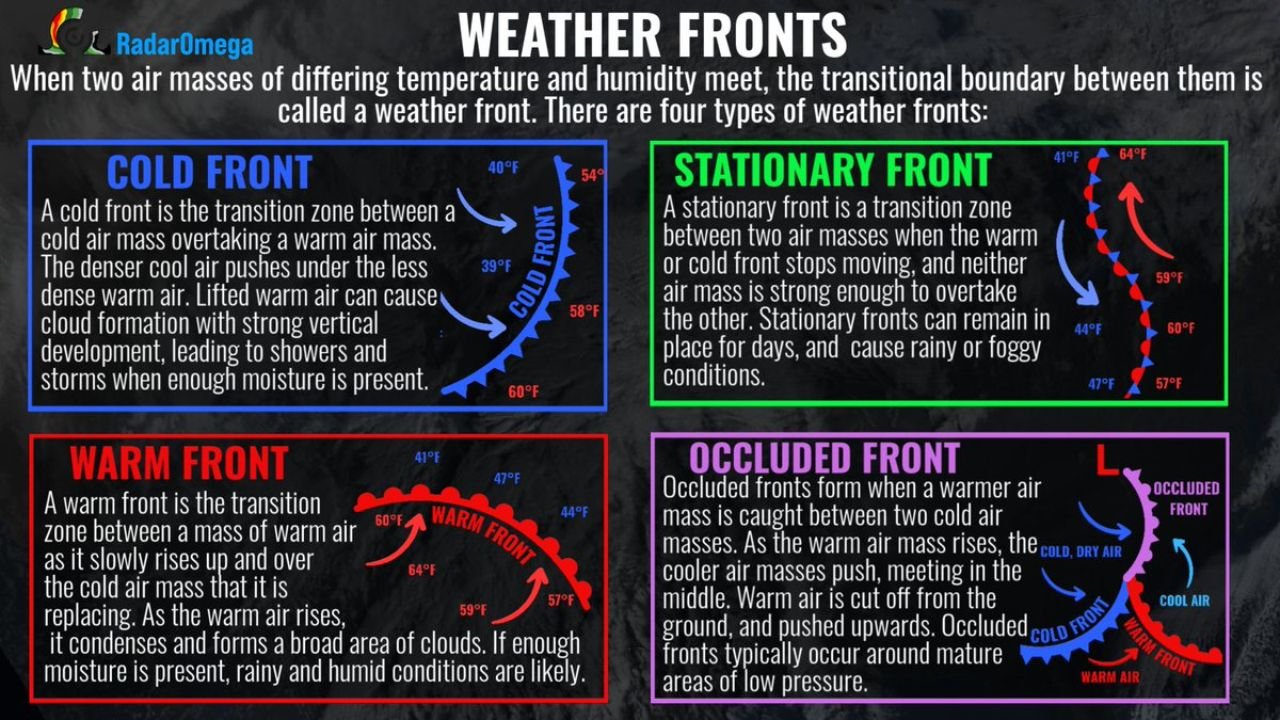
When two air masses of different temperature and humidity collide, the boundary between them is called a weather front. Understanding the four main types — cold fronts, warm fronts, stationary fronts and occluded fronts — can help explain why conditions can change so quickly from sunshine to storms.
Cold Front: The Storm Trigger
A cold front forms when a colder, denser air mass advances and undercuts a warmer air mass.
As the cold air wedges beneath the warm air, the warm air is forced upward rapidly. This rising motion can lead to:
- Towering clouds
- Heavy showers
- Thunderstorms
- Sudden wind shifts
- Sharp temperature drops
Cold fronts are often responsible for severe weather outbreaks across states like Oklahoma, Kansas, Missouri, Texas and Illinois, especially during spring.
After the front passes, skies typically clear and temperatures fall noticeably.
Warm Front: Steady Rain and Rising Humidity
A warm front occurs when a warm air mass gradually slides up and over a retreating cooler air mass.
Because the lifting process is more gradual, warm fronts usually bring:
- Widespread cloud cover
- Steady rain or drizzle
- Foggy conditions
- Increasing humidity
Cities in the Northeast, including New York, Boston and Philadelphia, often experience prolonged cloudy and damp periods ahead of warm fronts.
Once the front passes, temperatures climb and the air feels noticeably more humid.
Stationary Front: When Weather Stalls
A stationary front forms when neither the warm nor cold air mass is strong enough to displace the other.
These fronts can linger for days, producing:
- Extended rain events
- Persistent clouds
- Repeated rounds of showers
Stationary fronts are often linked to multi-day rainfall events in regions like the Southeast, Mississippi Valley and Ohio Valley.
Because the boundary barely moves, communities along it can see heavy rainfall totals over time.
Occluded Front: Complex and Often Stormy
An occluded front develops when a cold front overtakes a warm front, lifting the warm air completely off the ground.
This typically happens around mature low-pressure systems and can bring:
- Widespread precipitation
- Gusty winds
- Complex temperature patterns
Occluded fronts are frequently associated with strong storm systems tracking across the Great Lakes, Upper Midwest and Northeast.
Why Fronts Matter
Weather fronts are more than just lines on a map — they signal changing atmospheric conditions that affect daily life.
They determine:
- When temperatures spike or plunge
- Where thunderstorms develop
- How long rain may last
- When breezy or windy conditions arrive
From cold fronts sweeping across Texas and Colorado, to warm fronts lifting into Georgia and the Carolinas, to stationary fronts draped over the Ohio Valley, these boundaries shape much of the nation’s active weather.
Knowing the difference between them can make it easier to interpret forecasts and understand what kind of weather is likely next.
For more insights into the forces shaping weather patterns across the country, stay with ChicagoMusicGuide.com.