
Colorado Braces for Exceptional March Heatwave as Powerful Heat Dome Threatens Denver Highs and Rocky Mountain Snowpack
DENVER, COLORADO — An exceptional early-season heatwave is poised to grip Colorado and the broader Southwest next week, as a powerful upper-level ridge settles over the western United States. Forecast guidance shows a strengthening heat dome parking directly over the West, bringing temperatures far above normal and raising concerns about rapid snowpack melt in the Colorado Rockies.
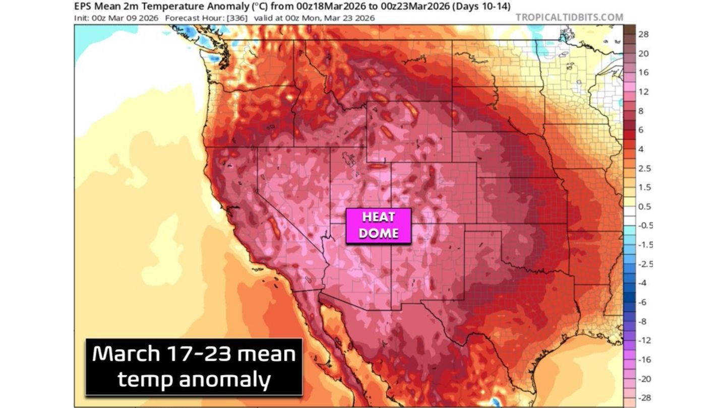
Long-range ensemble data for March 16–23 indicates widespread temperature anomalies across the West, with Colorado sitting squarely beneath the core of the ridge.
Heat Dome Locks Into Place Over the West
Upper-level pattern projections show a dominant high-pressure system building over Colorado, Utah, Arizona, and New Mexico, with 500mb height anomalies strongly favoring prolonged warmth. This ridge is stronger and positioned closer to Colorado than many recent early-spring warm spells.
Under this setup:
- Skies remain largely clear
- Subsidence promotes warming at the surface
- Storm systems are deflected north and east
The result is a multi-day stretch of well-above-average temperatures across the interior West.
Denver Near or Above 80°, Deserts Surge Into Triple Digits
Forecast mean temperature anomalies suggest widespread readings 10–20°F above normal across the Southwest. For Denver, that could translate into multiple days approaching or exceeding 80 degrees, unusually warm for mid-to-late March.
Farther south and west, desert regions in Arizona, southern Nevada, and parts of southeastern California could surge into the triple digits, challenging early-season records.
The heat dome’s core appears centered over the Four Corners region, maximizing the warming effect across Colorado and surrounding states.
Snowpack Concerns in the Colorado Rockies
The developing heatwave arrives at a particularly vulnerable time for Colorado’s mountain snowpack. With increasing March sun angle and largely clear skies expected, accelerated melting is likely across lower and mid-elevation terrain.
Early melt-off can:
- Reduce late-season snowpack recovery potential
- Increase evaporation rates
- Worsen drought conditions heading into summer
This pattern raises concerns that hopes for meaningful snowpack improvement this season may diminish if the ridge persists through the forecast window.
Prolonged Warm Pattern Through March 23
Ensemble mean guidance for March 16–23 keeps the ridge anchored over the West, indicating this is not a brief two-day spike but potentially a prolonged warm episode. With the jet stream displaced northward, cooler air remains confined to the northern Plains and Upper Midwest while the Southwest continues heating.
Colorado remains under the bullseye of the strongest anomaly zone, reinforcing confidence in above-normal temperatures throughout the period.
What This Means for Colorado Residents
Residents across Denver, Colorado Springs, Boulder, and mountain communities should prepare for early-season warmth more typical of late spring or early summer.
While warm days may feel welcome, the broader impacts — including snowpack loss and drought intensification — remain a growing concern. Officials and water managers will closely monitor melt rates as the heat dome strengthens.
For continued coverage on Colorado heat trends, Western weather patterns, and national climate impacts, visit ChicagoMusicGuide.com for ongoing updates and analysis.