
Colorado High Country Faces Rain–Snow Battle Sunday–Tuesday as 6,000-Foot Line Becomes the Deciding Factor
COLORADO — A new storm system is set to move into Colorado Sunday into Monday, but the real story may unfold Monday night into Tuesday as temperatures teeter near critical elevation thresholds.
Forecast guidance shows widespread precipitation across central and eastern Colorado, but whether communities see rain or accumulating snow will depend heavily on elevation — particularly around the 6,000-foot mark.
Sunday–Monday: Modest Start, Mixed Precipitation
The first phase of the system arrives Sunday into Monday and appears relatively modest in intensity.
Precipitation coverage expands across:
- The Front Range
- The Denver metro area
- Foothill communities
- Central Colorado mountain zones
- Eastern plains
However, temperature profiles suggest that elevations below approximately 6,000 feet could see primarily rain rather than snow.
This places cities like:
- Denver
- Aurora
- Fort Collins
- Colorado Springs
near a tricky rain–snow transition zone depending on exact surface temperatures and overnight cooling.
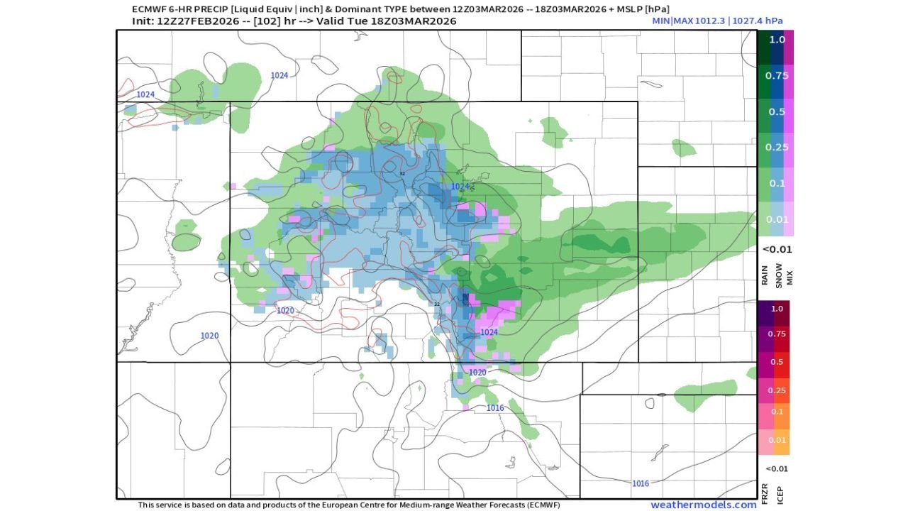
Monday Night into Tuesday: Stronger Dynamics
Model projections valid Tuesday afternoon show a more consolidated precipitation shield centered across central and eastern Colorado.
Heavier precipitation appears across:
- The Denver metro region
- Southward toward Colorado Springs
- West into foothill and mountain communities
- East onto portions of the High Plains
Higher elevations remain favored for snow accumulation, while lower elevations could stay mostly rain if temperatures hold just above freezing.
Small shifts of just a degree or two could dramatically change outcomes for the urban corridor.
Elevation Matters: 6,000 Feet Is Key
The 6,000-foot level becomes the dividing line:
- Above 6,000 feet: Greater confidence in accumulating snow
- Below 6,000 feet: Rain likely dominates unless nighttime cooling strengthens
Foothill communities west of Denver and higher terrain south toward the Palmer Divide are especially sensitive to this threshold.
Another Storm Lurks Thursday–Friday
After this early-week system exits, guidance indicates another storm arriving Thursday into Friday.
While details remain less certain, the pattern suggests:
- Continued active Pacific energy
- Additional precipitation chances
- Ongoing temperature uncertainty
If colder air filters in behind the first system, later storms could lean snowier at lower elevations.
Bigger Picture: Pattern Becoming More Active
The broader pattern favors multiple disturbances tracking across the Rockies in quick succession.
While the Sunday–Monday system may not be particularly intense, the sequence of storms through the week suggests an increasingly dynamic setup.
Residents across Colorado should prepare for:
- Periods of rain in lower elevations
- Mountain snow
- Slushy or slick travel in foothills
- Changing forecasts as temperature details sharpen
Bottom Line
Colorado’s upcoming storm is less about raw intensity and more about temperature precision.
Rain below 6,000 feet remains the leading scenario Sunday into early Monday, but Monday night into Tuesday carries greater potential for impactful precipitation — especially in higher terrain.
And with another storm already lining up for late week, the pattern is far from finished.
Stay with ChicagoMusicGuide.com for continued updates as this evolving Colorado storm sequence unfolds.