
Colorado Snowpack Hits Worst Levels on Record as Statewide Totals Sit Near 55% of Normal in Early February
UNITED STATES — As of February 4, 2026, Colorado’s snowpack situation has officially reached a historic low, with statewide snow-water equivalent measuring just 55% of the long-term median, making this the worst snowpack-to-date ever recorded for this point in the season.
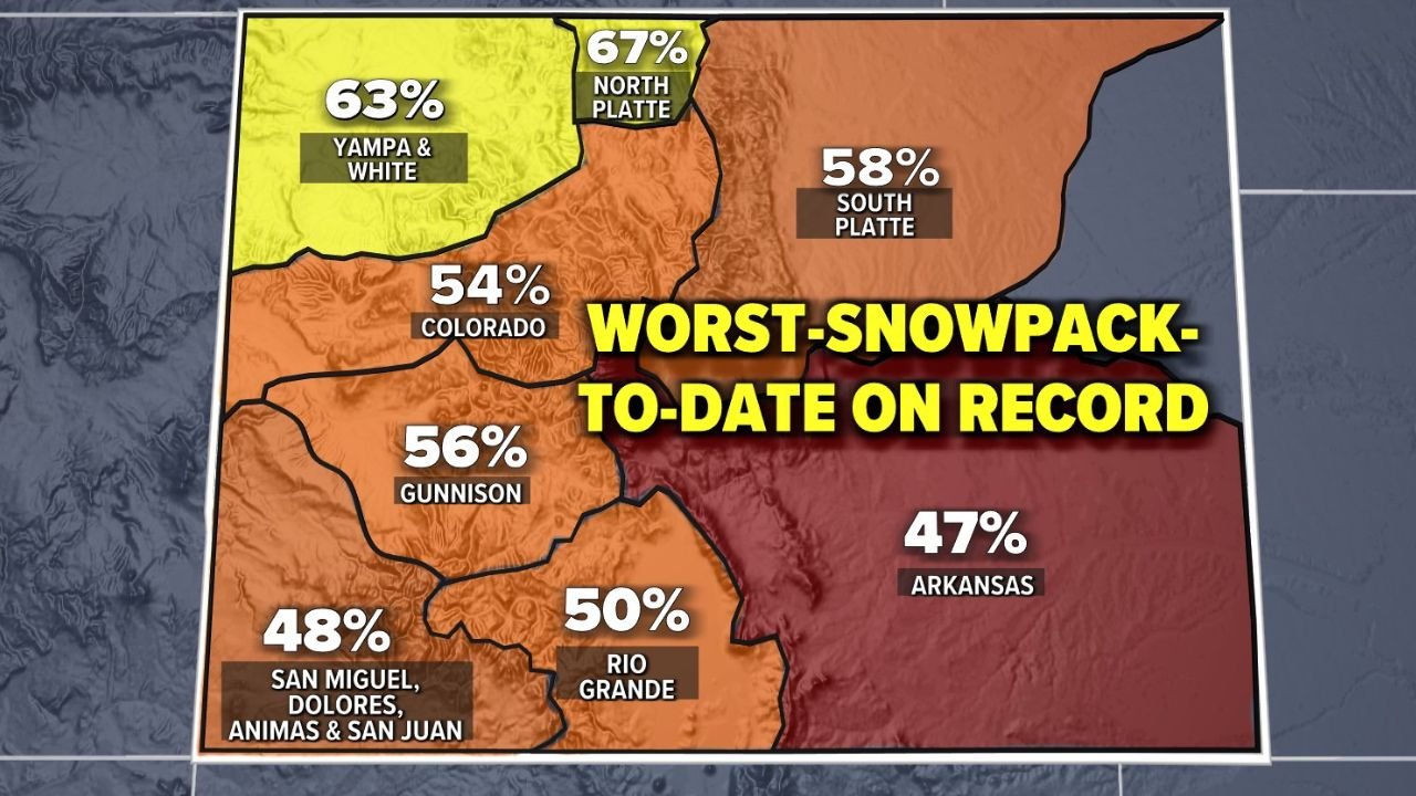
Updated snowpack graphics and basin data show Colorado is not even close to normal levels, with several major river basins sitting below half of where they should be as the heart of winter continues.
Statewide Snowpack Breakdown Shows Widespread Deficits
According to the latest basin-by-basin analysis issued on February 3, every major region of Colorado is running far behind normal:
- Statewide Average: 55% of median
- Yampa & White Basin: 63%
- North Platte Basin: 67%
- South Platte Basin: 58%
- Gunnison Basin: 56%
- Colorado River Basin: 54%
- Rio Grande Basin: 50%
- San Miguel, Dolores, Animas & San Juan Basins: 48%
The Arkansas River Basin is in the most severe condition, sitting at just 47% of median, placing southern and southeastern Colorado in particularly dangerous territory heading deeper into winter.
Season-to-Date Trends Confirm a Record-Breaking Shortfall
Long-term snow-water equivalent tracking shows Colorado’s snowpack curve running well below the historical minimum range since early winter.
As of February 2–3, the state has already passed the point where recovery becomes increasingly difficult without sustained, frequent storm systems.
Key indicators from the seasonal graph show:
- Only 55% of median snowpack achieved
- Just 32% of median peak reached
- Roughly 65 days remaining until normal seasonal peak
- Percentile ranking effectively at zero
Meteorologists warn that the longer this deficit persists, the harder it becomes to recover even with above-average snowfall later in the season.
What It Would Take to Recover From This Deficit
Forecasters stress that isolated storms will not be enough to reverse current conditions. Colorado would need a near-continuous storm track from late February through April — sometimes described as a “railroad track” pattern — to make meaningful gains.
Without that kind of sustained activity:
- Spring runoff volumes could be sharply reduced
- Drought conditions may worsen heading into summer
- Water supply planning across the state could face major strain
Why This Matters Beyond the Mountains
Low snowpack doesn’t just impact ski resorts. Snow-water equivalent is critical for:
- Reservoir refill
- Agricultural irrigation
- Municipal water supply
- Wildfire risk later in the year
With snowpack barely halfway to normal at this point in winter, concerns are already growing about summer water shortages and elevated fire danger if conditions fail to improve soon.
Outlook Heading Into Mid-February
As of now, there is no clear signal for a long-lasting storm pattern capable of rapidly rebuilding snowpack statewide. Short-term systems may help locally, but forecasters say time is becoming the biggest enemy.
Colorado still has opportunities to recover — but the window is narrowing fast.
Stay with Chicagomusicguide.com for continued winter weather updates, long-range outlooks, and impact-focused reporting as the 2026 snow season unfolds.