
Colorado Winter Storm Brings Snow Back to Mountains and I-25 Corridor With Uncertain Totals Through Sunday Morning
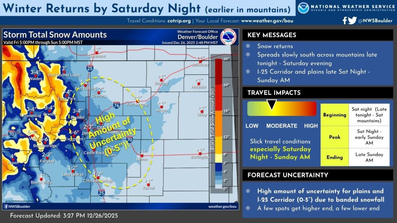
COLORADO — Snow is making a return across the state late Saturday, with a winter weather system first impacting the northern and central mountains before gradually spreading south and east into the I-70 mountain corridor and the I-25 corridor overnight into early Sunday, according to updated National Weather Service forecasts.
Forecasters say the system will bring banded snowfall, meaning snow totals could vary sharply over short distances, increasing uncertainty for communities along the Front Range and eastern plains.
Snow Begins in the Mountains Before Spreading South and East
Snow is expected to develop late Saturday in Colorado’s northern and central mountain ranges, including areas near Walden, Grandby, Kremmling, and Red Feather Lakes. These higher elevations are likely to see the earliest and most consistent snowfall, with totals generally ranging from 3 to 8 inches, and locally higher amounts in favored terrain.
As the system progresses, snow will expand southward into the I-70 mountain corridor, impacting travel near Eisenhower Tunnel, Vail Pass, and Berthoud Pass by Saturday evening.
I-25 Corridor Faces Overnight Snow With High Uncertainty
By late Saturday night into early Sunday morning, snow is expected to reach the I-25 corridor, including areas near Denver, Boulder, Fort Collins, Castle Rock, and Colorado Springs.
Forecast guidance shows high uncertainty in snowfall amounts for the plains and urban corridor, with potential totals ranging from 0 to 5 inches depending on how narrow snow bands set up. Some locations may receive minimal accumulation, while nearby areas could see several inches in a short period.
Meteorologists emphasize that banded snowfall could lead to rapidly changing road conditions even where totals remain modest.
Travel Impacts Most Likely Saturday Night Into Sunday Morning
Slick and snow-covered roads are most likely during the late Saturday night through early Sunday morning window, especially along:
- The I-70 mountain corridor
- The I-25 corridor
- Foothill and Palmer Divide communities
The highest travel impacts are expected during this overnight period, with improving conditions anticipated later Sunday morning as snowfall tapers off.
Snow Tapers Off Sunday With Lingering Uncertainty
Snow is forecast to gradually end from west to east late Sunday morning, with most areas seeing improving conditions by midday. However, forecasters caution that snowfall totals may still shift slightly as the system evolves, especially across the plains.
The National Weather Service notes that while some locations could exceed forecast amounts, others may see lower totals due to the uneven nature of banded snow.
What Colorado Residents Should Know
- Snow begins late Saturday in the mountains
- Snow reaches the I-25 corridor overnight
- High variability in snowfall amounts is expected
- Slick travel conditions likely late Saturday night into early Sunday
- Conditions improve late Sunday morning
Snow may not be extreme, but its timing and uneven distribution could still create headaches for travelers across Colorado.
For more regional weather updates, forecasts, and travel-related coverage, follow ChicagoMusicGuide.com and stay prepared as winter conditions return to the Rockies.