
Colorado’s Front Range Braces for 85 MPH Mountain Winds, Extreme Fire Danger, 16” Snow Near Steamboat and Near-Record Warmth in One Volatile Day
BOULDER, COLORADO — An unusually volatile February setup is lining up for the Front Range on Tuesday, combining high mountain winds, near-critical to extreme fire danger, accumulating mountain snow, and near-record warmth — all within a 24-hour window.
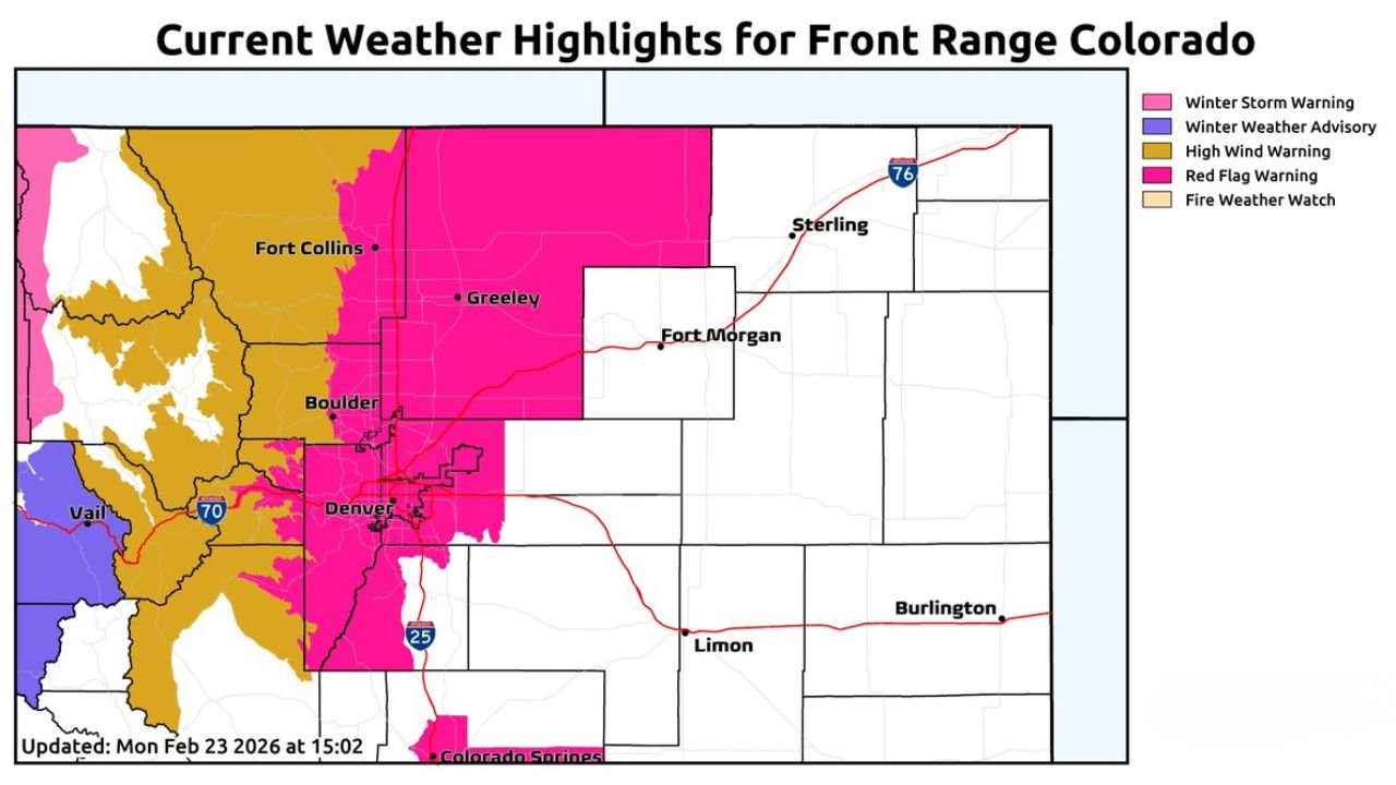
Updated weather highlights show multiple warnings stretching from Fort Collins and Boulder through Denver and into the foothills, with impacts varying sharply by elevation.
Here’s a breakdown of the four major elements shaping this active day.
High Winds in the Mountains and Foothills
The most intense conditions will target elevations above 7,000 feet, including mountain communities and exposed foothill ridges.
- Peak gusts up to 85 MPH possible
- Strongest winds expected mid-morning through evening
- High Wind Warnings in effect for portions of the foothills and mountain zones
There remains some uncertainty about how far downslope the strongest winds will mix. Current projections suggest Boulder may avoid the most extreme gusts, but forecasters caution that small shifts could push stronger winds farther downhill.
Travel in high-elevation corridors, including stretches near Vail and along I-70, may become hazardous during peak wind periods.
Near-Critical to Extreme Fire Danger
While mountain zones deal with damaging wind potential, the lower elevations — including Boulder and the Denver Metro area — face a different but equally serious threat.
Forecast details indicate:
- Wind gusts 20–35 MPH across lower elevations
- Relative humidity dropping to 10–15%
- Foothill elevations between 6,500 and 8,000 feet potentially seeing extreme fire danger
Red Flag Warnings are posted across parts of the Front Range, including areas west of Fort Collins, Boulder, and Denver.
The dangerous overlap of very low humidity and gusty winds creates conditions where any spark could spread rapidly. Even though wind speeds in Denver proper may be lower than in the mountains, the extremely dry air significantly raises wildfire risk.
Mountain Snow Returns Tuesday Evening
As the system evolves, conditions will flip dramatically in the higher terrain.
Snow is expected to begin Tuesday evening and continue into Wednesday evening, particularly along:
- The Continental Divide
- Mountain passes west of Denver
- Areas near Steamboat Springs
Projected snowfall totals include:
- 5 to 11 inches along the Divide and key passes
- Up to 16 inches near Steamboat
The combination of strong winds and accumulating snow could produce blowing snow and reduced visibility, making travel difficult overnight and into Wednesday.
Winter Weather Advisories and Winter Storm Warnings are posted in portions of the high country, especially west of the Front Range urban corridor.
Near-Record Warmth Along the Front Range
Adding another layer of complexity, much of the Front Range will experience unseasonably warm temperatures ahead of the system’s colder push.
Forecast highs across the urban corridor, including:
- Boulder
- Denver
- Fort Collins
are expected to land between 66°F and 72°F.
For context, Boulder’s February 24 record stands at 72°F. Extensive cloud cover may prevent records from being broken, but temperatures will still approach late-spring levels.
This warmth contributes directly to the elevated fire danger and highlights the dramatic air mass contrasts involved in this system.
A Classic Colorado Contrast Day
Few states showcase elevation-driven weather contrasts quite like Colorado — and Tuesday will be a textbook example.
Within a short drive:
- Near-record warmth in Denver
- Extreme fire conditions in the foothills
- 85 MPH winds in higher elevations
- Heavy accumulating snow west of the Divide
Residents across the Front Range — from Fort Collins and Boulder to Denver and Vail — should monitor updated forecasts throughout the day as conditions evolve rapidly.
For continuing analysis of major weather setups across the U.S., stay with ChicagoMusicGuide.com.