
Colorado’s Upper Basin Snowpack Has Collapsed to the 0th Percentile With Nine Days Until Peak and Lakes Powell and Mead Now Facing the Very Real Threat of Near-Record Low Inflows This Year
DENVER, CO — The numbers coming out of the Upper Colorado River Basin right now are not just alarming — they are historically unprecedented. As of March 28, 2026, the snowpack across 130 monitoring sites in the Upper Colorado Basin has fallen to the 0th percentile of all years on record. Not the bottom 10 percent. Not the bottom 5 percent. The absolute floor of recorded history. And with only nine days remaining until the typical peak snowpack date, there is no realistic path to recovery before melt season begins.
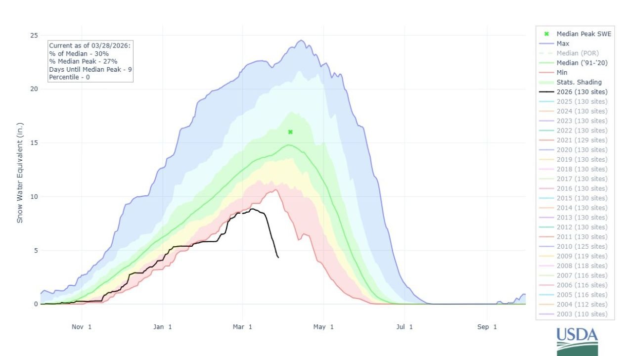
What the USDA Data Is Showing Right Now
The USDA Snow Water Equivalent chart, current as of March 28, 2026, tracks snowpack across 130 monitoring sites in the Upper Colorado River Basin and compares the current season against every year on record. The black line representing 2026 tells a story that is painful to look at for anyone who depends on Colorado River water.
The key data points as of March 28, 2026:
- Current SWE as a percentage of median: Only 30% of what is considered a normal snowpack for this time of year
- Percentage of median peak: Only 27% of the typical peak Snow Water Equivalent the basin should be building toward
- Days until median peak: Just 9 days — the snowpack should be near its maximum by approximately April 6th
- Current percentile ranking: 0 — meaning 2026 is tracking at or below every single year in the entire period of record across these 130 sites
That last number is the one that stops the conversation cold. A 0th percentile reading means this is the worst snowpack on record for the Upper Colorado Basin at this point in the season. The black line on the USDA chart is not just below the minimum historical envelope — it has broken through the floor of what has ever been observed.
Nine Days to Peak — And No Way to Catch Up
The median peak for Upper Colorado Basin snowpack typically occurs in early April — roughly nine days from the current data date. That means the snowpack should currently be in its final and most critical building phase, accumulating the last inches of Snow Water Equivalent before temperatures warm and melt season begins.
Instead, the 2026 snowpack has already begun declining. The black line on the chart shows a clear downward turn starting in mid-to-late March — meaning melt is already outpacing accumulation across much of the basin. The record heat wave that shattered more than 1,100 daily temperature records across the western United States between March 1 and March 26 was not a neutral event for Colorado’s snowpack. It accelerated melt at exactly the wrong time in the seasonal cycle.
With only nine days to median peak and snowpack already trending downward, the 2026 Upper Colorado Basin SWE total is effectively locked in at historically catastrophic levels.
What This Means for Lakes Powell and Mead
The Upper Colorado River Basin is not just a weather story. It is a national water supply crisis story. The snowpack that accumulates across the Colorado Rockies each winter is the primary source of unregulated inflow into Lake Powell — and from Powell, water flows downstream to Lake Mead, the largest reservoir in the United States by volume.
These two reservoirs together supply water to over 40 million people across seven states — Arizona, California, Colorado, Nevada, New Mexico, Utah and Wyoming — as well as critical agricultural water for millions of acres of farmland across the Southwest.
When snowpack collapses to the 0th percentile, the downstream consequences are direct and severe. Unregulated inflow into Lake Powell could approach near-record lows in 2026 — a scenario that was already being discussed in water management circles before this season’s snowpack data confirmed the worst-case trajectory.
Lake Powell and Lake Mead have spent the last several years in a precarious recovery from the extended drought conditions that drove both reservoirs to historically low levels. A near-record low inflow year in 2026 threatens to reverse much of that recovery and push water levels back toward the critical thresholds that trigger mandatory water use reductions across the Colorado River Compact states.
Snowpack Crisis Data Summary
| Metric | 2026 Value | Normal Value | Status |
|---|---|---|---|
| Current SWE % of Median | 30% | 100% | 🔴 Catastrophic |
| % of Median Peak SWE | 27% | 100% | 🔴 Catastrophic |
| Current Percentile | 0th | 50th | 🔴 All-Time Record Low |
| Days Until Median Peak | 9 days | — | 🔴 No Recovery Possible |
| Monitoring Sites | 130 sites | 130 sites | ✅ Full Coverage |
| Inflow Forecast for Powell | Near-Record Low | Average | 🔴 Critical |
State-by-State Water Supply Impact
🔴 Colorado — The source state. Upper Colorado Basin snowpack at the 0th percentile means Colorado’s rivers will see dramatically reduced spring runoff. Agricultural water users along the Front Range and Western Slope face a critically dry irrigation season.
🔴 Arizona — Lake Mead is Arizona’s primary Colorado River water source. Near-record low Powell inflows mean reduced Lake Mead levels, directly threatening the Central Arizona Project deliveries that supply Phoenix, Tucson and the surrounding agricultural regions.
🔴 Nevada — Las Vegas receives approximately 90% of its water from Lake Mead. A low inflow year that reverses recent reservoir recovery puts Nevada’s water security back in focus after years of aggressive conservation measures.
🔴 California — The Lower Colorado River supports agricultural operations across the Imperial Valley and municipal supplies for parts of Southern California. Reduced reservoir levels tighten water allocation across all Lower Basin users.
🟠 Utah and Wyoming — Upper Basin states with direct exposure to reduced river flows from the Colorado system. Water compacts and agricultural allocations in both states are directly tied to annual snowpack performance in the Upper Basin.
🟠 New Mexico — Receives Colorado River water through compact allocations. Reduced inflow years impact water availability across the San Juan River system and downstream New Mexico water users.
The Comparison That Puts This in Perspective
The data description makes a comparison that is worth sitting with. The Upper Colorado Basin snowpack right now is no better than Arizona — a desert state that receives minimal winter snowpack in normal years. For the mountain basin that feeds the most managed river system in the American West to be tracking at Arizona-comparable snowpack levels in late March is a statement about the severity of what the 2026 snow season has delivered.
This is not a local weather story. It is a regional water crisis with national implications that will play out across reservoir levels, water allocations, crop production and municipal water management across seven western states for the remainder of 2026 and potentially beyond.
The Colorado River Water Crisis Is Not a Future Problem — It Is Happening Right Now
Snowpack deficits, reservoir levels and water supply updates across the West will continue developing through spring and summer 2026. Stay informed at ChicagoMusicGuide.com — your source for breaking water supply analysis, snowpack data and drought coverage across Colorado, Arizona, Nevada and the entire western United States.