
Connecticut Snow Forecast Signals Light Tuesday Morning Accumulations With Slick Travel and Rapid Improvement
CONNECTICUT — A Tuesday morning snow event is expected to move across Connecticut as a warm front approaches the region, bringing light accumulations, slick early travel, and improving conditions by midday, according to the latest forecast analysis and snowfall mapping.
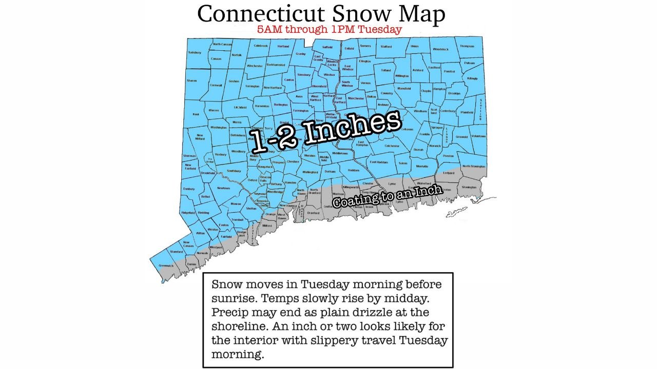
Forecasters expect most of the state to see 1–2 inches of snow, particularly across interior Connecticut, while shoreline areas may see a coating up to one inch before precipitation potentially transitions to drizzle or light rain. While some model guidance has hinted at higher totals, confidence remains highest in a lighter, shorter-duration event.
Snow Timing and Accumulation Outlook Across Connecticut
Snow is expected to begin early Tuesday morning, before sunrise, spreading across the state during the 5 a.m. to 1 p.m. window. The Connecticut snow map highlights a broad swath of 1–2 inches inland, with lower totals closer to the coast due to warmer air moving in off Long Island Sound.
Temperatures are forecast to slowly rise through the morning, reaching the mid-30s by afternoon, which should limit additional accumulation and help snow taper off quickly. While a few locations may briefly see steadier snowfall early on, the system lacks deep moisture, keeping overall impacts modest but noticeable.
Travel Impacts and School Disruptions Likely Tuesday Morning
Despite the light totals, slick road conditions are likely during the Tuesday morning commute, especially on untreated roads, bridges, and overpasses. The early timing increases the risk for localized travel slowdowns, though conditions should improve rapidly by late morning as snow ends and temperatures rise.
Given the timing, school closures and delays are likely, particularly since many districts are already operating on early dismissal schedules. Confidence is slightly lower along the immediate shoreline, but even there, brief slippery conditions are possible before precipitation changes over.
Why This System Stays on the Lighter Side
This event is driven by a warm front lifting northward, which limits snow duration and promotes a quick transition toward milder air. Forecasters note that while a few models have suggested 3–4 inches, those solutions appear overdone, given the lack of sustained cold air and marginal surface temperatures.
Most locations should see snow taper off by early afternoon, with little to no refreeze expected later in the day. Any lingering precipitation near the coast is more likely to fall as light drizzle rather than snow.
What Residents Should Expect After the Snow Ends
By Tuesday afternoon, travel conditions should steadily improve, and lingering impacts will be minimal. Roads should become mainly wet as temperatures continue to climb, reducing the risk of prolonged hazards. No significant additional winter weather is expected immediately after this system.
For residents, the key takeaway is caution early, confidence later — allow extra time in the morning, but expect a quick return to normal conditions as the day progresses.
For continued weather updates, snow forecasts, and regional impact coverage, visit ChicagoMusicGuide.com, where we track major weather patterns affecting communities across the country.