
Dallas, Oklahoma City and Kansas City Watch Mid-April Severe Weather Surge as Storm Energy Builds After Quiet Stretch
DALLAS, TEXAS — A temporary lull in severe weather activity across the United States is expected over the next five days, but new forecast data shows a concerning uptick in storm potential developing by mid-April, especially for cities like Dallas, Oklahoma City, and Kansas City.
Meteorological models indicate that while storm chances remain low in the short term, a strong return of severe weather energy is likely to impact the Great Plains and Midwest regions around April 12–15, signaling the next active phase of the spring season.
Quiet Pattern Dominates Early Week Before Rapid Shift
For much of the upcoming week, conditions across the central U.S. are expected to remain relatively stable, with:
- Limited severe storm development
- Lower atmospheric instability
- Reduced tornado potential
This temporary break is reflected in forecast ensemble data showing suppressed storm activity through roughly April 9–10, giving regions across Texas, Oklahoma, and Missouri a brief window of calmer weather.
However, this quiet period is not expected to last long.
By late in the week, subtle increases in atmospheric energy begin to emerge, signaling that conditions are starting to shift toward a more favorable setup for severe storms.
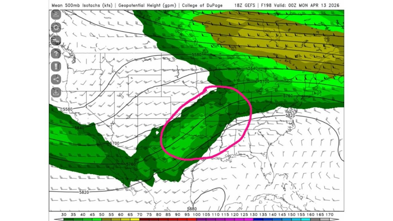
Jet Stream Setup Signals Growing Severe Risk
Forecast maps highlight a developing jet stream pattern stretching from northern Mexico into Texas, Oklahoma, and the central Plains, a key ingredient for severe weather outbreaks.
This setup is expected to:
- Increase wind shear across the region
- Enhance storm organization potential
- Support the development of strong to severe thunderstorms
The highlighted corridor includes major population centers such as:
- Dallas–Fort Worth Metroplex
- Oklahoma City
- Kansas City
This region is often a focal point for spring severe weather outbreaks, and the evolving pattern suggests that storm chances will increase significantly as we approach mid-April.
Storm Energy Trends Point to Mid-April Spike
Ensemble guidance tracking storm potential (SCP values) shows a noticeable trend:
- Low and stable values early in the period
- Gradual increase around April 11–12
- A more pronounced spike in atmospheric energy by April 13–15
This rising trend indicates that the atmosphere is becoming increasingly supportive of:
- Severe thunderstorms
- Damaging wind events
- Large hail potential
- Possibly tornado development if conditions align
While exact timing and locations will become clearer in the coming days, the pattern consistency across multiple models increases confidence in a more active period ahead.
Great Plains and Midwest Enter Next Active Phase
As the pattern evolves, the focus for severe weather is expected to expand beyond Texas and Oklahoma into parts of the Midwest, including areas near:
- Kansas City
- Springfield, Missouri
- Potentially extending toward Illinois and surrounding regions
This progression is typical during spring, where storm systems track northeast, bringing multi-state severe weather risks.
The combination of:
- Returning Gulf moisture
- Strengthening jet stream dynamics
- Rising instability
creates a setup that could support organized storm systems rather than isolated activity.
What This Means for the Days Ahead
Residents across Dallas, Oklahoma City, and Kansas City should use the current quiet period to stay prepared, as the weather pattern is expected to turn more volatile quickly.
Key expectations include:
- Calmer conditions through early next week
- A gradual increase in storm chances by midweek
- Potential for more widespread severe weather around April 13–15
While it is too early to define exact impacts, the signals for a more active severe weather phase are becoming clearer with each model run.
Staying aware of forecast updates will be important as this system develops and approaches.
For more updates on severe weather trends, storm outlooks, and regional forecasts, visit ChicagoMusicGuide.com and stay informed as conditions evolve across the Plains and Midwest.