
Dangerous Arctic Cold Surge Set to Slam the Northeast With Temperatures 20–40 Degrees Below Normal
NEW YORK, NEW YORK — A powerful and unusually early-season Arctic outbreak is set to plunge the Northeast into extreme cold by Sunday night into Monday, delivering some of the most significant temperature drops of December so far. Forecast models show temperatures falling 20 to 40 degrees below normal, with widespread single-digit lows, subzero wind chills, and highs that will struggle to climb above freezing in many areas.
Winter has not even officially begun — yet the atmosphere is preparing to deliver January-level cold.
Arctic Air Dives South Into the Northeast This Weekend
A deep reservoir of brutally cold air, currently sitting over Alaska and northwest Canada (where readings have fallen to -40°F to -50°F), is forecast to surge down the jet stream and settle directly over the Northeast late Sunday.
The core of the cold will impact:
- New York
- New Jersey
- Pennsylvania
- Massachusetts
- Connecticut
- Rhode Island
- Vermont
- New Hampshire
- Maine
Expect temperatures to crash into the teens and single digits by early Monday, with interior areas of New York and New England plunging below zero.
Wind chills will be far worse.
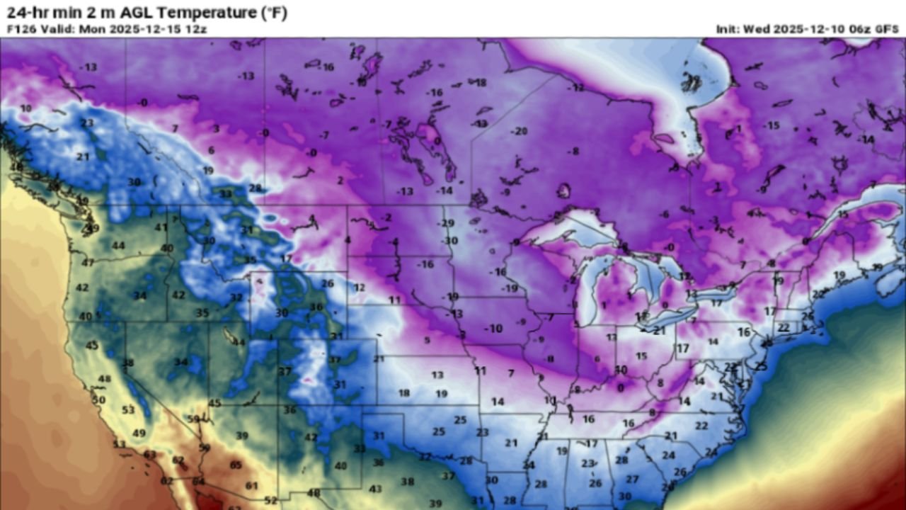
Forecast Maps Reveal One of the Strongest December Cold Shots in Years
The temperature maps show a sharp, widespread Arctic plunge:
- Purple and deep blue shades dominate the Northeast, indicating lows from -5°F to -20°F in interior New England and upstate New York.
- Major coastal cities — New York City, Boston, Providence, Philadelphia — are projected to drop into the teens, with wind chills near or below 0°F.
- The cold extends deep into the Mid-Atlantic, with Washington, D.C., and Baltimore falling into the teens as well.
- This level of temperature departure — up to 40°F below seasonal norms — is unusually severe for mid-December.
Forecasters warn that the cold will arrive quickly and intensify overnight, leading to widespread hazards early Monday.
Why This Arctic Surge Stands Out
Meteorologists note several factors that make this event unusually intense:
- A direct north-to-south Arctic pipeline, allowing polar air to spill south with little moderation.
- A steep temperature gradient, causing faster and more aggressive cold intrusion.
- Broad geographical coverage, with nearly the entire Northeast experiencing significant departures from average.
- Strength reminiscent of mid-winter cold waves, but arriving nearly two weeks before the start of astronomical winter.
This combination increases the likelihood of travel impacts, energy demand spikes, and dangerous exposure risks.
Local Impacts Across the Northeast
Residents across the region should prepare for:
- Single-digit morning lows, with many inland areas dipping below zero
- Wind chills between -10°F and -25°F, especially across upstate New York and northern New England
- Hard freezes reaching unusually far south into the Mid-Atlantic
- Hazardous road conditions during the Monday morning commute due to ice formation
- Pets and livestock at risk without proper shelter
- Significant heating demand, especially for older homes and apartment buildings in major cities
Even areas near the coast will experience a rare burst of deep cold.
How Long Will the Freeze Last?
The most intense cold is expected from Sunday night through Monday afternoon, though some areas may remain well below normal into Tuesday morning.
A brief midweek warm-up is possible — but long-range patterns show the potential for additional cold intrusions later in December.
Early signs of winter are showing up loud and clear.
How Are You Preparing for the Freeze?
The Northeast is about to face the strongest December cold surge in years. How are you getting ready? Share your local temperatures, safety tips, and winter experiences — and follow ChicagoMusicGuide.com for continuing coverage as this Arctic blast moves in.