
Dangerous Ice Storm Expected to Cripple North Carolina and South Carolina With Widespread Freezing Rain, Sleet, and Snow Through Monday
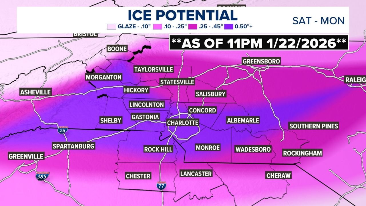
CHARLOTTE, NORTH CAROLINA — A high-impact winter storm is setting up across central and western North Carolina and parts of northern South Carolina, with widespread freezing rain, heavy sleet, and accumulating snow expected from Saturday night through Sunday night and into early Monday. Updated regional ice and sleet maps show dangerous ice accumulations exceeding one-half inch in several counties, a level capable of downing trees, snapping power lines, and making travel nearly impossible.
Ice Accumulation Is the Primary and Most Dangerous Threat
Forecast guidance highlights freezing rain and ice accretion as the dominant hazard, particularly across the Charlotte metro area, Piedmont, and foothills. Many locations are expected to receive 0.50 inches or more of ice, with pockets of .25 to .45 inches extending across surrounding counties.
In Mecklenburg County, including Charlotte, Huntersville, Cornelius, and Davidson, ice totals are projected to exceed one-half inch, even where sleet or snow accumulates on top. Similar ice totals are expected in Gaston, Cabarrus, Lincoln, and York counties, placing a large population under significant infrastructure stress.
Ice at this magnitude is especially dangerous because it adds extreme weight to trees and power lines, dramatically increasing the risk of widespread and prolonged power outages.
Sleet and Snow Add to the Impact Across the Region
While ice leads the threat, sleet and snow will pile on top of the ice, worsening road conditions and complicating cleanup efforts. Much of the Charlotte region is expected to see 1–3 inches of sleet and snow, with lesser amounts farther south and higher totals north and west.
Across Catawba, Burke, and Watauga counties, sleet and snow totals increase to 3–5 inches, with Beech Mountain potentially seeing 4–7 inches. These northern and higher-elevation areas may see slightly less ice overall, but heavier frozen precipitation totals will still create hazardous conditions.
Meteorologists caution that sleet behaves more like ice than snow, offering little traction and making roads just as dangerous as freezing rain.
County-by-County Highlights Show Widespread Risk
Updated projections show nearly every major county in the region impacted, including:
- Mecklenburg County: 1–3 inches sleet/snow with 0.50+ inches of ice
- Gaston and Cabarrus counties: 1–3 inches sleet/snow with significant icing
- Union and Rowan counties: Trace to 1 inch sleet/snow with moderate ice
- Catawba and Burke counties: 3–5 inches sleet/snow with .25–.50 inches of ice
- York County, South Carolina: 1–3 inches sleet/snow with 0.50+ inches of ice
- Lancaster and Chester counties: Light sleet/snow with .25–.45 inches of ice
The geographic spread of damaging ice totals across multiple counties makes this storm particularly concerning for regional power grids and emergency services.
Timeline: When Conditions Will Be at Their Worst
The storm is expected to evolve in stages, with impacts worsening over time:
- Saturday evening: Temperatures fall below freezing as precipitation begins
- Overnight Saturday: Freezing rain and sleet intensify across western and central counties
- Sunday morning through evening: Prolonged icing continues, with sleet and snow mixing in
- Sunday night into early Monday: Additional ice accumulation possible before precipitation tapers
Even after precipitation ends, icy roads and downed infrastructure may persist well into Monday, especially in shaded and untreated areas.
Travel and Power Outage Concerns Grow
Officials warn that travel may become extremely dangerous or impossible, particularly on bridges, overpasses, and secondary roads. The combination of ice underneath sleet and snow creates near-zero traction conditions.
Power companies are preparing for potentially widespread outages, as ice loads of half an inch or more are historically associated with long-duration restoration efforts, especially when combined with cold temperatures.
Residents are urged to avoid unnecessary travel, secure emergency supplies, and prepare for extended power disruptions, including safe heating alternatives and backup lighting.
Why This Storm Stands Out
What makes this winter storm especially dangerous is the sheer coverage of damaging ice, not just isolated pockets. Large urban and suburban areas, including Charlotte and its surrounding communities, fall directly within the highest ice accumulation zone, increasing the potential for significant regional disruption rather than localized issues.
As this storm unfolds, conditions may change rapidly, and small temperature shifts could alter precipitation types. Staying alert to updates will be critical as the event progresses.
As North Carolina and South Carolina brace for one of the most impactful winter weather events of the season, preparation and caution will be essential to reduce risk and disruption. For continued winter storm coverage, regional impact updates, and weather alerts across the Midwest and Southeast, visit ChicagoMusicGuide.com.