
Deep Freeze Targets Great Lakes, Pennsylvania, Maryland, and Northeast as Arctic Air Pushes Temperatures 25–30°F Below Normal
OHIO — A significant cold air invasion is setting up across the eastern United States next week, with the Great Lakes, Mid-Atlantic, and Northeast facing some of the coldest temperatures of the winter season so far. Forecast guidance from NOAA and European weather models shows widespread temperatures plunging well below seasonal averages, with multiple states experiencing prolonged sub-freezing conditions.
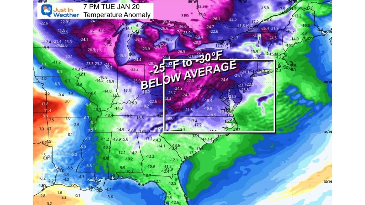
What the Forecast Data Clearly Shows
Latest 6–10 day temperature outlooks indicate a strong winter pattern locking into place from the Great Lakes through the Mid-Atlantic and into the Northeast. Large portions of Pennsylvania, Ohio, Maryland, New York, and surrounding states are expected to run 25 to 30 degrees below average, especially during the middle of next week.
Temperature anomaly maps highlight a deep trough anchored over the eastern U.S., allowing Arctic air to spill southward with little resistance. This setup is climatologically aligned with the coldest part of January, making the impacts more noticeable and longer-lasting.
Deep Freeze Events Expected Next Week
Forecast temperature plots suggest two separate deep-freeze periods, beginning early next week and extending into the following days. Urban areas, including parts of Baltimore, Pittsburgh, Cleveland, and central Pennsylvania, could see daytime highs struggle to reach the upper 20s, with overnight lows dropping well below freezing.
Some locations may remain below freezing for multiple consecutive days, increasing the risk of icy conditions, frozen pipes, and stress on infrastructure.
Will This Cold Pattern Produce Snow? Confidence Remains Lower
While the cold air is well supported by model data, snowfall confidence remains lower at this time. Meteorologists caution against trusting snowfall maps that extend five or more days into the future, especially when storm placement and strength are still uncertain.
That said, the setup does support:
- Light snow accumulations across parts of western and northern Pennsylvania
- Lake-effect snow developing downwind of the Great Lakes
- Snow squalls, particularly Thursday into Friday, which can cause sudden travel hazards
Heavier snowfall remains possible but not guaranteed, depending on how embedded disturbances evolve within the broader cold pattern.
Why Early Snow Maps Missed the Mark
Earlier model runs, particularly from the GFS, hinted at a much stronger storm scenario. However, updated data now shows a positively tilted trough, which favors a weaker, more stretched-out system rather than a compact, high-impact snowstorm.
This evolution limits widespread heavy snow but still allows for bursts of winter weather, especially in snowbelt regions.
What to Expect Moving Forward
- Coldest temperatures of the season likely for many areas
- Travel disruptions possible from snow squalls and icy roads
- Snow chances remain fluid, with higher confidence closer to midweek
- Residents should prepare for extended cold, even where snow remains limited
Meteorologists emphasize focusing on temperature impacts first, as the cold itself will be the dominant story regardless of snowfall totals.
Final Outlook
This upcoming pattern reinforces why long-range snowfall hype should be treated cautiously. The cold air signal is strong and reliable — snow specifics are not yet locked in.
As confidence increases later this week, clearer answers on snowfall placement and intensity will follow.
Stay tuned to ChicagoMusicGuide.com for continued weather updates, regional impact breakdowns, and clear explanations as conditions evolve.