
Denver, Colorado Snow Chances Rise March 5–11 as ECMWF Ensembles Show Persistent Cold Signal and Multiple Snow Windows
DENVER, COLORADO — If you’re waiting for another round of snow in the Mile High City, new long-range guidance is offering cautious optimism. The latest ensemble data covering March 5 through March 11, 2026, shows a consistent cold signal across Colorado along with multiple windows where snow could develop.
While this remains within the extended 7–14 day range, the overall pattern is becoming more supportive of wintry weather returning to the Front Range.
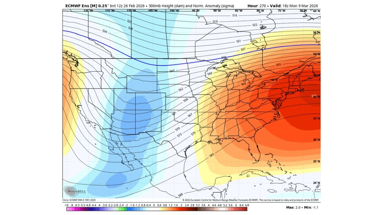
Strong Cold Trough Setting Up Over the Rockies
The 500mb ensemble height anomaly map highlights a broad trough settling over:
- Colorado
- Wyoming
- New Mexico
- Portions of Utah and Arizona
Blue shading across the central Rockies indicates below-normal height anomalies — a classic signal for colder-than-average air aloft.
Meanwhile, a strong ridge builds over:
- The Southeast U.S.
- The Mid-Atlantic
- Portions of the Ohio Valley
That east-west contrast helps lock in a northwest-to-westerly flow into Colorado, keeping colder air in place across the Denver metro.
Denver Ensemble Snow Signals Appear Multiple Times
The ECMWF ensemble snowfall panel for Denver International Airport (DEN) shows several clusters of members producing measurable snowfall between March 5 and March 11.
Key takeaways from the ensemble output:
- Multiple spikes in snowfall potential
- Mean snowfall signal increasing around March 6–7
- Additional weaker signals toward March 9–11
- Wide spread among members — meaning uncertainty remains
While no single major storm is locked in yet, the presence of repeated signals suggests at least a few snow opportunities rather than a one-and-done system.
Timing Windows to Watch in Colorado
Based on the ensemble clustering:
Primary window:
- Around March 6–7
Secondary window:
- Around March 9–11
Given Denver’s elevation (over 5,000 feet), even modest disturbances within a cold pattern can produce accumulating snowfall.
The ensemble mean remains modest, but several individual members show higher-end outcomes if shortwaves align favorably.
Why This Pattern Matters for Denver
When a broad trough anchors over the central Rockies:
- Temperatures stay below seasonal averages
- Storm systems track through the Four Corners region
- Upslope flow potential increases along the Front Range
That combination is often favorable for Denver snowfall events — especially in early March, when cold air is still available but sun angle begins increasing.
Uncertainty Still Remains
This remains a 7–14 day outlook, meaning:
- Exact storm tracks are not defined
- Snowfall amounts cannot yet be locked in
- Individual waves may trend stronger or weaker
However, what stands out is the consistency of the cold signal across multiple ensemble runs — not just a one-cycle anomaly.
Consistency in long-range guidance often increases confidence that at least part of the pattern will verify.
Bottom Line for Denver, Colorado
Between March 5 and March 11, ensemble guidance supports:
- A sustained colder-than-normal pattern
- At least a couple snow opportunities
- Increasing potential for measurable accumulation
While it’s too early to forecast specific totals, the ingredients are coming together for Denver’s next round of March snow chances.
Stay with ChicagoMusicGuide.com for continued national weather coverage as we monitor how this developing Rockies pattern evolves.