
District of Columbia, Maryland, and Virginia Finally Thaw as Washington, D.C. Breaks Historic Freezing Streak
WASHINGTON, D.C. — After more than nine straight days locked at or below freezing, Washington, D.C. finally climbed above the critical 32-degree mark on Monday afternoon, reaching 33°F at 2 p.m. The milestone ended a 233-hour streak of freezing or subfreezing temperatures, marking one of the longest cold runs in the city’s recorded history and offering a small but meaningful sign of relief across the District, Maryland, and Northern Virginia.
The reading marked the first time the nation’s capital rose above freezing since January 23, finally closing the door on an unusually persistent Arctic grip.
A Rare and Historic Cold Streak Comes to an End
The prolonged freeze now stands as a nine-day streak when measured by full calendar days, tying for the fifth-longest stretch at or below freezing in Washington, D.C. records dating back to 1872.
While temperatures technically flirted with a tenth consecutive day, official climatological accounting places the event just shy of that mark. Even so, the duration alone places this cold spell among the most significant the city has experienced in over a century.
Meteorologists noted that the persistence of the cold — rather than just the intensity — is what made this event so exceptional.
National Airport Records Highlight How Unusual This Event Was
At Ronald Reagan Washington National Airport, the city’s primary climate observation site since 1945, this marks only the second time on record such a prolonged freezing streak has occurred.
The only comparable modern event came in December 1989, when the airport recorded a 10-day freezing streak. Every other cold stretch of similar length occurred before 1936, underscoring just how rare this episode was in the modern climate era.
For historical context, the longest freezing streak ever recorded in Washington, D.C. remains 12 days, occurring in January–February 1936 and again in February 1895.
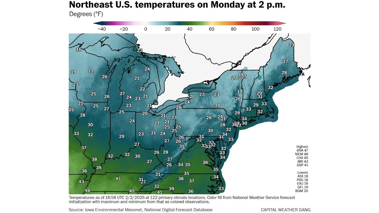
Temperatures Across the Northeast Show a Slow, Uneven Recovery
While Washington, D.C. edged above freezing, much of the Northeast and Great Lakes remained locked in cold conditions Monday afternoon. Temperature maps at 2 p.m. showed widespread readings in the 20s across Pennsylvania, New York, New England, and the Upper Midwest.
Cities across Ohio, Michigan, and upstate New York remained firmly below freezing, while coastal sections of the Mid-Atlantic hovered near the freezing line. Farther south, parts of Virginia, North Carolina, and Tennessee saw temperatures climb into the mid- to upper-30s, signaling the first broader signs of moderation.
This gradual warming highlights how the Arctic air mass is retreating unevenly, with the coldest air lingering longest across northern latitudes.
Why This Freeze Lasted So Long
The extended cold streak was driven by a persistent Arctic pattern, reinforced by repeated injections of cold air from Canada and limited opportunities for warmer air to penetrate the Mid-Atlantic.
Strong high-pressure systems repeatedly settled over the eastern United States, suppressing daytime warming and keeping overnight lows entrenched well below freezing. Snow cover across parts of the region further reinforced the cold by reflecting sunlight and limiting surface heating.
Forecasters note that while individual cold days are common, multi-day freezing stretches of this length are increasingly rare, making this event stand out even more.
A Small Step Toward Seasonal Relief
Though 33°F may seem insignificant, crossing above freezing carries meaningful impacts — from easing strain on infrastructure to allowing snow and ice to begin melting. It also signals that the atmosphere is slowly transitioning away from its most extreme winter pattern.
While additional cold snaps remain possible later in February, meteorologists expect gradual moderation across the Mid-Atlantic in the days ahead, with daytime highs more consistently climbing into the upper 30s and 40s.
For residents across the District of Columbia, Maryland, and Virginia, Monday’s modest thaw marked an important psychological and climatological turning point.
As winter patterns continue to evolve, moments like this offer perspective on just how exceptional recent conditions have been. For continued coverage of historic weather events, temperature trends, and regional climate milestones, visit ChicagoMusicGuide.com for the latest updates.