
Dual Low-Pressure System Targets Mid-Atlantic and Southern New England as Heavier Rain Shifts East and Wintry Mix Stays North
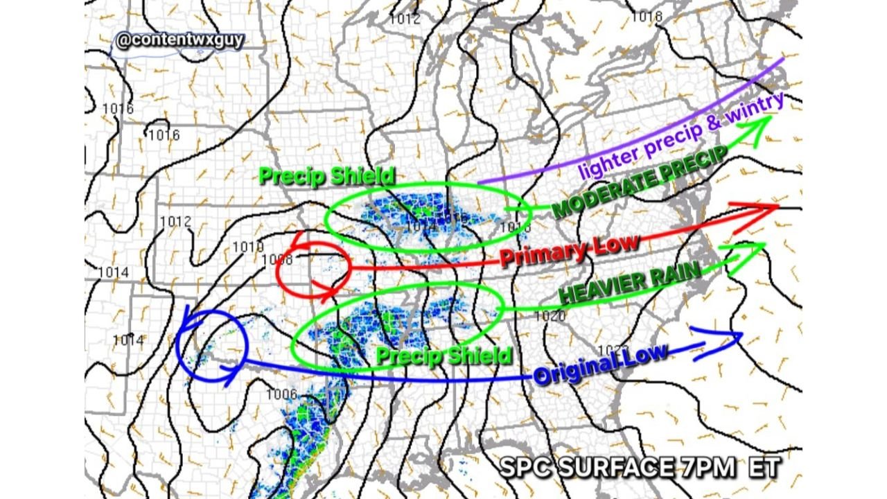
UNITED STATES — A complex weather setup is unfolding across the eastern half of the country tonight as two separate low-pressure systems influence precipitation from the Ohio Valley to the Mid-Atlantic and into southern New England. New model guidance shows a “primary” low transporting moisture into the upper Mid-Atlantic, while an “original” low pulls a separate precipitation shield eastward — bringing heavier rainfall to parts of the lower Mid-Atlantic and lighter, wintry precipitation farther north.
The evolving structure suggests a split but coordinated system, with rain intensity and precipitation type changing sharply depending on location.
Primary Low Drives Moisture Into Upper Mid-Atlantic
The latest surface analysis (7 PM ET) highlights a primary low tracking east-northeast. This feature is responsible for lifting moisture into portions of:
- Central and eastern Pennsylvania
- Northern Maryland
- Northern Virginia
- Southern New Jersey
- Southern New England
This northern precipitation shield appears more fragmented and lighter overall, with areas north of the main rain axis experiencing light rain or mixed wintry precipitation, especially across interior Pennsylvania and into southern New England.
Colder air entrenched to the north means that communities farther inland — particularly higher elevations — may see snow or a rain/snow mix rather than plain rain.
Original Low Pulls Heavier Rain Into Lower Mid-Atlantic
Meanwhile, the original low — positioned farther southwest earlier in the system’s evolution — is dragging its own, more consolidated precipitation shield eastward.
That band is delivering moderate to heavier rainfall across:
- Southern and central Virginia
- Parts of West Virginia
- Southern Maryland
- The lower Delmarva region
This southern shield is more moisture-rich and better organized, with stronger lift and deeper saturation, supporting steadier rainfall rates compared to the northern band.
As this system continues east, the heavier rain axis is expected to shift toward the coastal Mid-Atlantic overnight.
Sharp Gradient Between Rain and Wintry Precipitation
One of the more notable features in this setup is the tight gradient between precipitation types.
North of the primary low’s track:
- Cooler surface temperatures support light rain transitioning to snow or a wintry mix
- Accumulations appear limited due to marginal temperatures and lighter intensity
South of the boundary:
- Warmer air dominates
- Rainfall becomes steadier and locally heavier
This kind of split-precipitation structure is typical when multiple lows interact and when cold air remains locked in across the Northeast while milder air surges in from the south.
How This Impacts the Broader Eastern U.S.
The combined effect of these lows is producing a corridor of precipitation stretching from the Ohio Valley through the Mid-Atlantic and into southern New England.
Key impacts include:
- Heavier rain across parts of Virginia and southern Maryland
- Moderate rain in the central Mid-Atlantic
- Light rain and wintry mix farther north
- Reduced travel visibility during periods of heavier rain
- Slick spots possible in colder northern areas
While this is not a major winter storm for most areas, the interaction between the two lows adds complexity to timing and precipitation type — particularly in interior zones where surface temperatures hover near freezing.
Why This Setup Matters
Dual-low structures can often prolong precipitation and create uneven impacts across relatively short distances. The presence of:
- A primary moisture-transporting low
- An original trailing low with its own precipitation shield
- A north-south temperature contrast
…means that communities separated by just 50 to 100 miles could see very different conditions.
In meteorological terms, this kind of arrangement enhances localized lift and creates overlapping precipitation zones — which is exactly what we’re seeing tonight across portions of the Mid-Atlantic and southern New England.
What Comes Next
As the original low continues east and the primary low lifts northeastward, precipitation coverage will gradually shift offshore. Northern zones may see lingering light precipitation before tapering off, while heavier rainfall exits the lower Mid-Atlantic by late evening or overnight.
Temperatures will determine whether any brief accumulations occur in interior northern locations, but widespread significant snow appears unlikely based on the current setup.
For travelers and residents across Pennsylvania, Maryland, Virginia, and southern New England, expect varying conditions over short distances — from steady rain to light wintry mix — as this dynamic system moves through.
Stay with ChicagoMusicGuide.com for continued national weather updates and detailed breakdowns of evolving storm systems across the country.