
Early April Could Bring Active Storm Pattern Across the Mississippi Valley and Midwest as Long-Range Models Signal Rising Rain and Severe Weather Potential
ST. LOUIS, MISSOURI — Long-range weather guidance is beginning to hint that early April could bring a more active storm pattern across the Mississippi Valley and parts of the Midwest, according to recent extended-range model projections.
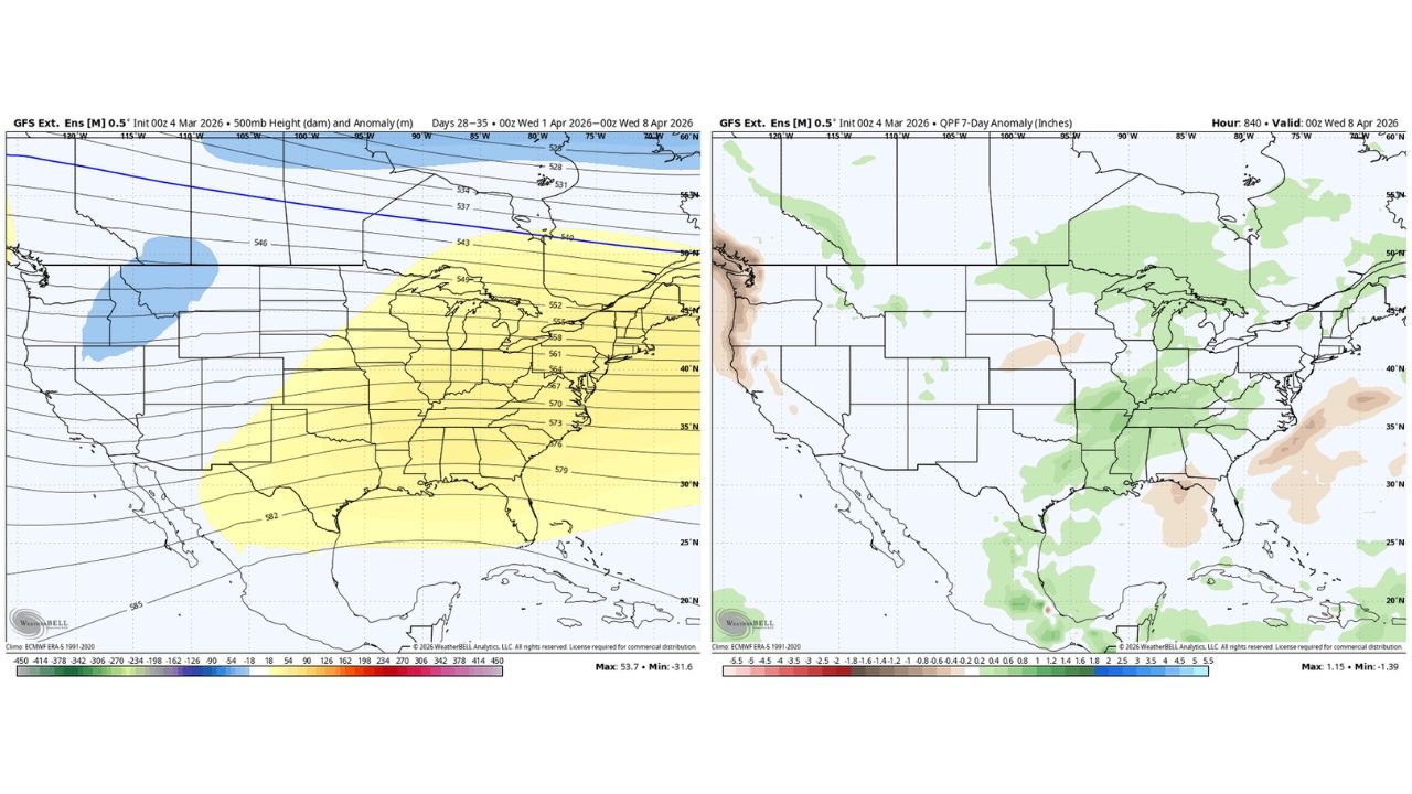
Meteorologists reviewing the latest GFS extended ensemble forecasts say there are early signs that the atmospheric pattern may shift toward western U.S. troughing combined with increased precipitation across the central United States, a setup that often favors storm systems and active weather across the Mississippi Valley.
While experts emphasize that specific storms cannot yet be predicted this far out, the emerging signals suggest the region could experience increased rainfall and potentially stronger weather systems as the calendar turns into April.
Long-Range Models Suggest Western U.S. Trough Pattern
One of the key signals appearing in the forecast models is the possibility of a trough forming across the western United States, a large-scale dip in the jet stream that can help steer storm systems across the central part of the country.
Model projections for the period between April 1 and April 8 show a pattern where atmospheric energy shifts across the southern Plains and Mississippi Valley, including states such as:
- Texas
- Arkansas
- Missouri
- Illinois
- Kentucky
- Tennessee
This type of pattern often promotes storm development along the boundary where warm Gulf moisture interacts with cooler air moving east from the Rockies.
Meteorologists say that when this configuration develops during early spring, it can sometimes lead to frequent storm systems moving across the central United States.
Precipitation Signals Increasing Across the Mississippi Valley
Another indicator supporting the possibility of an active pattern is the precipitation anomaly forecast, which highlights areas that could receive above-average rainfall during the early April period.
The model guidance shows higher precipitation potential across the Mississippi Valley, extending from:
- Arkansas
- Mississippi
- Tennessee
- Kentucky
- Missouri
- Southern Illinois
Cities such as Memphis, Nashville, St. Louis, Little Rock, and Paducah fall within areas where rainfall totals could trend above average during the early part of April.
Forecasters say this signal may indicate multiple storm systems tracking through the region over several days.
Midwest May Also Experience Increased Storm Activity
Although the strongest signals appear farther south, the broader pattern may also affect parts of the Midwest, including Illinois, Indiana, and surrounding states.
Meteorologists note that when storm systems track through the Mississippi Valley, they frequently move northeast toward the Great Lakes and Midwest, bringing periods of rain and thunderstorms.
Cities such as Chicago, Indianapolis, Louisville, and Cincinnati could see periodic rainfall and thunderstorm chances depending on how individual systems develop.
However, experts stress that long-range forecasts cannot determine exact storm timing or severity at this stage.
Too Early to Predict Specific Severe Weather Events
Despite the active signals appearing in model guidance, meteorologists caution that predicting individual severe weather events weeks in advance is not possible.
Long-range forecasts primarily identify large-scale atmospheric trends, rather than specific storms.
That means the current outlook should be viewed as an early indicator of a potentially active weather pattern, not a guaranteed severe weather outbreak.
Over the coming weeks, forecasters will continue monitoring temperature trends, Gulf moisture levels, and jet stream patterns to see whether the signals strengthen or fade.
Early Spring Often Brings Increasing Storm Activity
The transition into April typically marks a ramp-up in storm activity across the central United States, as warmer temperatures and increasing moisture from the Gulf of Mexico combine with strong upper-level weather systems.
This seasonal shift often leads to frequent rain events and occasional severe thunderstorms across the Mississippi Valley and Midwest.
While the exact details remain uncertain, the latest model guidance suggests the beginning of April could feature a busier weather pattern across the region.
For the latest updates on Midwest weather patterns, severe storm forecasts, and regional weather developments affecting Chicago and surrounding areas, visit ChicagoMusicGuide.com.