
Early April Pattern Sets Stage for Severe Weather From Texas and Oklahoma Through Illinois, Indiana and Ohio as Ridge Builds Over Eastern U.S.
UNITED STATES — Long-range forecast guidance is signaling an increasingly active severe weather pattern as April begins, with a developing upper-level ridge over the eastern United States and periodic western troughs combining to create a potentially volatile setup across the central part of the country.
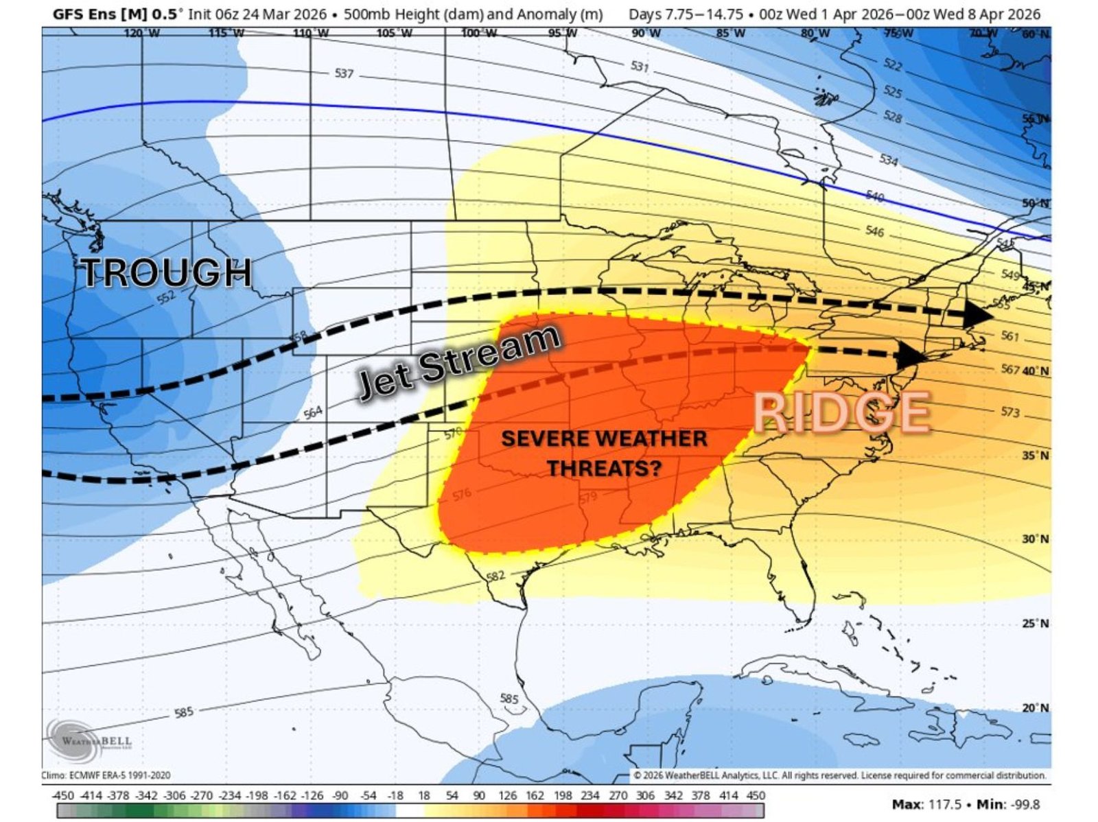
Ensemble data for the April 1–8 timeframe shows a pronounced trough digging into the western U.S. while a strengthening ridge builds across the eastern states. In between these features, the jet stream is forecast to arc from the Southwest through the Plains and into the Midwest — a corridor often associated with severe thunderstorm development.
Trough West, Ridge East: A Classic Severe Setup
The projected atmospheric pattern includes:
- A trough over the western U.S.
- A ridge centered over the eastern U.S.
- A strong jet stream extending across the central states
This configuration typically allows warm, moist air from the Gulf of Mexico to surge northward into the Plains and Midwest, while cooler, drier air pushes eastward from the Rockies. The collision of these air masses can provide the ingredients needed for severe thunderstorms.
Central U.S. in the Crosshairs
Model anomaly guidance highlights an elevated severe weather signal stretching from:
- Texas
- Oklahoma
- Kansas
- Missouri
- Arkansas
- Illinois
- Indiana
- Ohio
The highest concentration of potential appears centered across parts of Texas and Oklahoma, extending northeastward into the Mid-Mississippi Valley and lower Great Lakes region.
While it is too early to define specific outbreak days, the broad signal suggests that the first week of April could bring multiple opportunities for strong to severe storms somewhere within this corridor.
Why April Is a Transition Month
Early April often marks a seasonal shift toward more frequent severe weather events across the central United States. Increasing instability, longer daylight hours, and strengthening upper-level winds can combine to create favorable supercell environments.
The current ensemble support suggests that this year’s pattern may align with that typical transition window.
Uncertainty Remains
It is important to stress that this remains a Week 2 outlook. Details such as exact timing, storm intensity, and tornado potential will depend on short-term atmospheric trends that will become clearer as April approaches.
However, the developing trough–ridge structure is one to watch, especially across the Southern Plains and into the Midwest.
ChicagoMusicGuide.com will continue monitoring long-range severe weather signals as we move closer to the early April timeframe.