
East Coast Snowstorm Setup Raises Big Questions as Coastal Low Eyes Sunday–Monday Impact Zone
NEW YORK, NEW YORK — Forecasters are closely monitoring a developing coastal storm system that could bring snow, rain, or minimal impacts to parts of the Mid-Atlantic and Northeast late Sunday into Monday. While confidence in exact snowfall totals remains low, cold air is expected to settle into the region ahead of the system, creating a setup that could support a winter weather event.
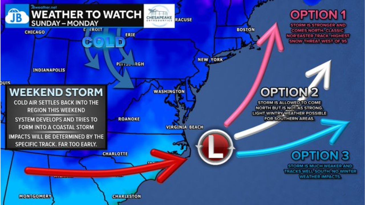
Meteorologists emphasize that it is still too early to determine precise impacts. However, the overall atmospheric pattern shows a disturbance moving across the southern United States that may organize along the coast and attempt to form a coastal low-pressure system.
Cold Air Returns Ahead of Developing Coastal System
The latest forecast guidance indicates that cold air will settle back into the Northeast and Mid-Atlantic before the storm arrives. Areas including Pittsburgh, Erie, Washington, D.C., Virginia Beach, New York City, and Boston are expected to be firmly within a colder air mass by Sunday.
This cold setup is a critical ingredient. Without it, precipitation would likely fall as rain. With it in place, the system could produce accumulating snow depending on its eventual track and strength. The projected cold air push extends southward into portions of Virginia and North Carolina, though temperatures there will be more marginal.
The presence of this colder air mass increases the potential for snow in interior locations, especially west of the Interstate 95 corridor, but exact impacts hinge entirely on how the coastal low develops.
Three Possible Storm Tracks Could Change Everything
Current model data shows significant disagreement on the system’s path. Meteorologists are outlining three primary track scenarios, each with different implications for snowfall and travel impacts.
Option 1: A stronger storm tracking north or northeast just offshore.
If the low intensifies and tracks closer to the coast, it could bring higher snow totals west of I-95, particularly into Pennsylvania, upstate New York, and parts of interior New England. This scenario presents the highest snow threat for inland communities.
Option 2: A moderate track slightly farther offshore.
In this setup, the storm still develops but is not as strong. Light winter weather impacts would be possible across portions of the Mid-Atlantic and Northeast, though snowfall amounts would be lower and more scattered.
Option 3: A weaker system tracking well south and east.
If the disturbance remains disorganized or tracks too far offshore, impacts would be minimal. In this case, much of the region would see little to no winter weather concerns.
Each scenario highlights just how sensitive this setup is to small atmospheric shifts. A slight deviation in storm track of 50 to 100 miles could dramatically change who sees snow and who sees rain.
Models Remain Divided, Confidence Still Low
Forecast models currently do not agree on the exact track or intensity of the coastal system. Some individual runs show measurable snowfall stretching from Virginia through New Jersey and into New York and Massachusetts, while others show the bulk of precipitation staying offshore.
Forecasters stress that these projections are based on individual model runs, not a consensus forecast. This winter season has already featured several cases where guidance struggled with coastal storm evolution, adding to the uncertainty.
Because of this lack of agreement, meteorologists describe the situation as an early heads-up rather than a confirmed snowstorm. Confidence is expected to improve over the next several days as more data becomes available and model trends stabilize.
Travelers along the I-95 corridor, as well as those in inland cities like Pittsburgh and upstate New York, should monitor updates closely. Even minor track adjustments could shift the snow axis significantly.
What to Watch Through the Weekend
Key factors to monitor include:
- Strength of the southern disturbance as it moves east
- Depth and positioning of the cold air mass
- How quickly the coastal low intensifies
- Whether the system tracks closer to the shoreline or remains offshore
Sunday into Monday remains the primary window for potential impacts. Any accumulating snow would likely develop late Sunday and continue into early Monday depending on location.
At this stage, forecasters caution against focusing on specific snowfall totals. Instead, attention should remain on overall storm evolution and track trends.
As the East Coast watches this developing system, preparation and awareness remain the best course of action. For continued updates on winter weather patterns, regional storm threats, and in-depth forecast coverage, visit ChicagoMusicGuide.com.