
Elevated Supercells Over Northern Oklahoma Bring Hail Threat Near Oklahoma City, But Tornado Risk Stays Low Tonight
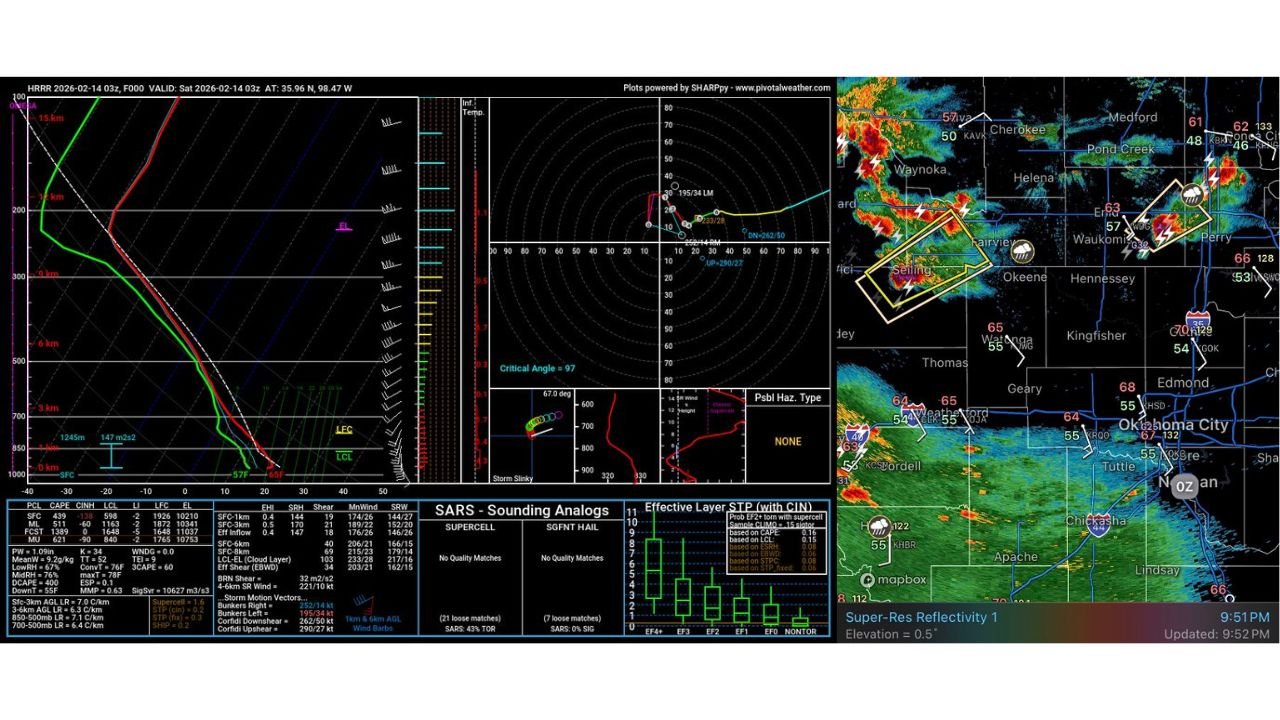
UNITED STATES — A cluster of isolated supercells across Northern Oklahoma, including areas near Seiling, Fairview, Perry, and just north of Oklahoma City, is drawing attention tonight. While radar imagery shows organized storms with lightning and pockets of rotation, the overall setup suggests hail is the primary concern, not tornadoes.
Surface Inversion Keeping Storms Elevated
Latest data indicates these supercells are elevated above a cooler surface layer, meaning they are feeding on warmer air just above ground level rather than pulling energy directly from the surface. This setup is known as a surface inversion, and it’s playing a major role in limiting the tornado threat.
Temperatures near the surface across northern and central Oklahoma remain relatively cool, while warmer air sits just above. That contrast creates a stable layer near the ground, preventing storms from fully tapping into surface-based instability.
Forecasters note the inversion is “quite tall,” but not unusual in these relatively dry environments.
Radar Highlights: Seiling to Perry Corridor
High-resolution radar imagery shows:
- A strong storm west of Seiling, producing frequent lightning.
- Another organized cell near Perry, northeast of Oklahoma City.
- Reflectivity signatures indicating heavy rain cores and potential hail.
- Local wind observations near storms showing gusts into the 40–60 mph range in spots.
Storm motion vectors and mid-level rotation are present, but they remain elevated — meaning any spin is occurring well above the surface.
Sounding Data: Why Tornadoes Are Unlikely
Atmospheric soundings from the HRRR model reveal:
- Limited surface-based CAPE (Convective Available Potential Energy).
- A stable boundary layer suppressing low-level updraft stretching.
- Weak effective-layer tornado parameters.
- Hail parameters more favorable than tornadic signatures.
The combination of elevated instability and weak low-level shear reduces the chance of a surface-based tornado forming tonight.
In simple terms: the storms have enough energy to produce hail and lightning, but not enough surface interaction for a significant tornado threat.
Hail Is the Main Concern
Because these storms are elevated, strong updrafts can suspend hailstones longer in the storm core. That increases the risk for:
- Quarter-sized hail or larger in isolated spots.
- Brief heavy downpours.
- Gusty winds beneath collapsing storm cores.
Communities including Oklahoma City, Edmond, Kingfisher, and surrounding areas may see passing showers and storms overnight, but the severe threat remains limited.
What Happens Next?
Storms are expected to gradually weaken or shift eastward as instability decreases overnight. Unless the surface layer destabilizes significantly — which models do not currently suggest — the tornado risk should remain minimal.
Still, as with any thunderstorm, residents should:
- Stay weather aware.
- Seek shelter if warnings are issued.
- Move vehicles indoors if hail approaches.
Severe weather setups like this can look intense on radar, but the details in the atmospheric profile matter. Tonight across Northern Oklahoma, those details favor hail over tornadoes.
For continued updates on national weather patterns and major storm developments affecting travel and touring artists across the country, stay with ChicagoMusicGuide.com.