
Explosive Sunday Wind Event Taking Aim at St. Louis, Memphis and Little Rock as 75 MPH Gusts and EF2+ Tornadoes Possible Into Illinois, Tennessee and Mississippi
ST. LOUIS, MISSOURI — An intense and rapidly strengthening storm system is expected to mature quickly through the day Sunday, setting the stage for a widespread and potentially high-impact severe weather event from Arkansas and Mississippi northward into Missouri and Illinois.
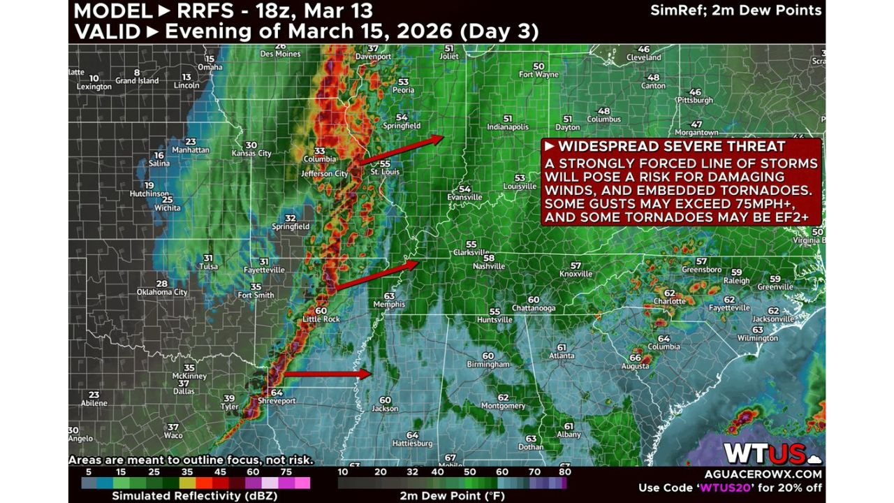
Evening forecast guidance highlights a strongly forced line of storms developing by mid to late afternoon, intensifying as it surges east. The projected corridor of greatest concern runs from Little Rock and Shreveport north through Memphis and into St. Louis and central Illinois, with impacts spreading toward western Tennessee and parts of Kentucky overnight.
Widespread Damaging Wind Threat Emerging
Forecasters indicate the primary hazard will be a broad swath of damaging straight-line winds as the frontal QLCS (quasi-linear convective system) organizes.
Some wind gusts may exceed 75 mph, particularly within bowing segments of the line. These types of events can produce extensive tree damage, structural impacts, and widespread power outages.
Cities in the more concentrated threat zone include:
- Little Rock, Arkansas
- Memphis, Tennessee
- St. Louis, Missouri
- Springfield, Missouri
- Central and southern Illinois
The line is expected to move quickly, limiting warning lead times in some communities.
Embedded Tornadoes, Some Potentially Strong
Embedded tornadoes remain a serious concern along the line. With strong wind shear and forcing in place, rotation can spin up quickly within embedded circulations.
Forecasters caution that some tornadoes could reach EF2 intensity or stronger, particularly if localized pockets of better moisture develop ahead of the line.
There are also questions about whether a higher-end tornado threat could materialize if storms are able to form more robustly in advance of the main band.
Moisture Questions Could Influence Storm Mode
One key uncertainty revolves around how much low-level moisture returns into Arkansas, Mississippi, and western Tennessee by Sunday evening.
If richer moisture surges northward:
- Discrete supercells could develop ahead of the line
- Large hail potential would increase
- Tornado intensity risk could climb
If moisture and instability remain somewhat limited, the event would still likely feature a high-impact wind threat, but hail may be more isolated and tornadoes more embedded within the line itself.
Overnight Impacts Into the Midwest and Deep South
The severe threat is expected to persist into the overnight and early Monday morning hours across parts of:
- Southern Illinois
- Western Kentucky
- Western Tennessee
- Northern Mississippi
Even as instability wanes, strong dynamic support and wind shear will likely allow the line to maintain strength.
Communities across the Midwest and Deep South should prepare for nighttime severe weather, which historically carries elevated risk due to reduced visibility and sleeping populations.
A High-Impact Setup
This system features strong upper-level dynamics, significant wind shear, and a sharply defined frontal boundary — a combination that often produces fast-moving, damaging squall lines with embedded tornado potential.
Residents across Arkansas, Mississippi, Tennessee, Missouri, and Illinois should review safety plans now and ensure multiple ways to receive warnings.
Sunday is shaping up to be a significant severe weather day across the central United States.
Stay with ChicagoMusicGuide.com for continued updates as this dangerous setup evolves.