
Farmers Across the Midwest Get a Brief Dry Window April 5 Through 10 Before Another Round of Widespread Moisture Returns to Illinois, Indiana and the Great Lakes Region Through Mid-April
DES MOINES, IA — After one of the most active and wet early April stretches in recent memory across the central United States, the latest long-range precipitation data is now showing something that farmers, field workers and outdoor planners across the Midwest have been waiting for — a brief but meaningful dry window opening around April 5th and lasting through approximately April 10th. But the relief is temporary. A second widespread period of moisture is already building back into the forecast for mid-April, targeting Illinois, Indiana, the Great Lakes and the upper Midwest with above-normal precipitation through April 15th. The April pattern is setting up as a classic wet-dry-wet cycle — and knowing when each window opens and closes is critical for anyone with time-sensitive field or outdoor work planned across the region.
Period One: April 5 Through April 10 — The Dry Window Opens
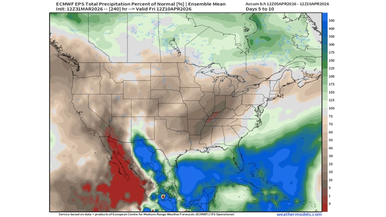
The ECMWF EPS Ensemble Mean precipitation percent of normal map, valid April 5 through April 10, shows a dramatically drier-than-normal signal across most of the continental United States compared to what the country has been dealing with through late March and early April.
The brown and tan shading — representing below-normal precipitation — covers an enormous geographic footprint across the map. The central United States from the Pacific Coast states eastward through the Plains, Midwest and much of the South is showing precipitation at 25% to 75% of normal during this period. In plain terms, the models are forecasting a significantly quieter weather pattern across the core of the country between approximately April 5th and April 10th.
For Iowa, Illinois, Indiana, Missouri and Ohio — the states that have absorbed repeated rounds of heavy rainfall through the multi-day severe weather outbreak of early April — this dry window represents the first real opportunity for saturated soils to begin draining, field conditions to firm up and early spring fieldwork to begin. The window is not completely dry across all areas, but the below-normal precipitation signal is consistent and meaningful enough to represent a genuine break from the active pattern.
The Southeast and Gulf Coast show a different story — with deep blue above-normal precipitation across Florida, the Gulf Coast and into parts of the Caribbean during this period. This wet signal in the south reflects the ongoing moisture pipeline from the Atlantic and Gulf that has been active throughout the spring pattern, even as the central U.S. gets its brief respite.
The western mountain states also show mostly below-normal precipitation during April 5-10 — consistent with the drier pattern that has been contributing to the historic snowpack deficits across Colorado, Utah and the surrounding mountain ranges.
Period Two: April 10 Through April 15 — Moisture Returns to the Midwest
The second ECMWF EPS map, valid April 10 through April 15, tells the story of what happens after the brief dry window closes — and the message for the Midwest and Great Lakes is clear. Above-normal precipitation returns to a broad corridor covering Iowa, Illinois, Indiana, Michigan, Ohio and Wisconsin during the April 10 through 15 window.
The green shading — representing above-normal precipitation — covers the Great Lakes corridor and extends southward into the Ohio Valley during this second period. The signal is not as dramatic as the April 1-5 heavy rainfall event, but it is consistent and broad enough to indicate that the dry window between April 5 and 10 is the primary fieldwork opportunity of the month for Midwest farmers — and it may be the only clean window before mid-April moisture arrives.
The northern Great Lakes and upper Midwest — Minnesota, Wisconsin, Michigan’s Upper Peninsula — show some of the strongest above-normal precipitation signals during the April 10-15 period, consistent with the continued active pattern across the northern tier that has been keeping snow chances alive through mid-April across the Dakotas and Minnesota.
The Plains states — Kansas, Nebraska and Oklahoma — show mixed signals during the second period, with some areas trending toward above normal and others near normal. The severe weather pattern that has been active across the Plains through early April may continue in a modified form during the mid-April window.
Two-Period Precipitation Outlook Table
| Period | Central Midwest | Great Lakes | Plains | Southeast |
|---|---|---|---|---|
| April 5–10 | 🟤 Below Normal — Dry Window | 🟤 Below Normal | 🟤 Below Normal | 🔵 Above Normal |
| April 10–15 | 🟢 Above Normal Returns | 🟢 Above Normal | ⬜ Mixed | 🔵 Continued Wet |
| Fieldwork Window | 🟢 Yes — April 5-10 | 🟢 Limited | 🟢 Better window | N/A |
| Overall Confidence | Moderate | Moderate | Low-Moderate | Moderate-High |
State-by-State April Precipitation Outlook
🟢 Iowa — The dry window from April 5 through 10 provides the first realistic opportunity for field entry since early March across much of the state. Soil moisture will remain elevated from the early April rainfall but surface conditions should improve enough for field operations by mid-week of the dry window. Above-normal moisture returns April 10-15.
🟢 Illinois — Central and northern Illinois face the same dry window opportunity April 5-10 followed by returning moisture April 10-15. The green above-normal signal during the second period is concentrated across the northern half of the state — Chicago and the surrounding agricultural areas face a wet return by mid-April.
🟢 Indiana — The dry window gives Indiana farmers their first clean field entry opportunity of April. The return moisture signal for April 10-15 is moderate across Indiana — not as strong as the first-period wet signal, but enough to limit extended fieldwork beyond the dry window.
🟢 Ohio — Inside both the dry window and the returning moisture zone. Ohio’s wet spring pattern will reassert itself around April 10th after a brief improvement period.
🟢 Michigan — The Great Lakes moisture return during April 10-15 is strongest in Michigan. The dry window April 5-10 gives Michigan a brief improvement but the return signal is pronounced for the Lower Peninsula.
🟤 Kansas, Nebraska, Missouri — Primarily in the dry and below-normal zone during both periods, with some above-normal signals developing during the second period across eastern portions of these states. The Plains states get the most extended dry window of any part of the central U.S. during April — beneficial for winter wheat development and early spring fieldwork.
🔵 Florida and Gulf Coast — Above-normal precipitation both periods. The Gulf moisture pipeline remains active through mid-April for the Southeast and Florida corridor.
What This Means for Midwest Farmers Right Now
The message from this two-period outlook is direct and actionable for agricultural operations across Iowa, Illinois, Indiana and Ohio: April 5 through 10 is your window — plan your most critical fieldwork around it.
After the extraordinary early April rainfall that followed an already-wet March, soils across the Corn Belt are saturated to depths that will take several days of dry and windy conditions to drain adequately for field entry. The April 5-10 dry window may not provide fully ideal field conditions on Day 1 — but by April 7th or 8th, conditions across many areas should be improving enough to support carefully timed field operations.
The return moisture signal starting around April 10th means this window is approximately 5 to 7 days long — enough for critical early planting preparation work across much of the region but not unlimited time. Prioritize the most time-sensitive operations for the early part of the window when confidence in the dry pattern is highest.
For operations that cannot be completed during the April 5-10 window, the mid-April wet pattern will need to run its course before the next significant dry window opens — likely in the April 18-22 timeframe based on current extended range signals, though that far-out forecast carries substantial uncertainty.
April’s Wet and Dry Windows Are Now Taking Shape and the Clock on the First Field Opportunity Is Already Ticking
More precipitation pattern updates are ahead as the mid-April moisture signal comes into sharper focus. Stay informed at ChicagoMusicGuide.com — your source for agricultural weather outlooks, precipitation pattern analysis and fieldwork timing updates across Iowa, Illinois, Indiana, Ohio and the entire United States.