
February 19–20 Severe Weather Threat Emerges Across Plains and Ohio Valley as GFS and EURO Highlight Strong Wind Shear Setup
UNITED STATES — New model guidance from both the GFS (Global Forecast System) and the EURO (ECMWF) is signaling a potentially active severe weather setup for February 19–20, stretching from the southern Plains into the Ohio Valley. While still several days out, forecast shear maps show a classic configuration that could support strong to severe thunderstorms if instability materializes.
Meteorologists caution that timing and storm intensity remain uncertain, but both major global models are highlighting an environment capable of supporting organized storms.
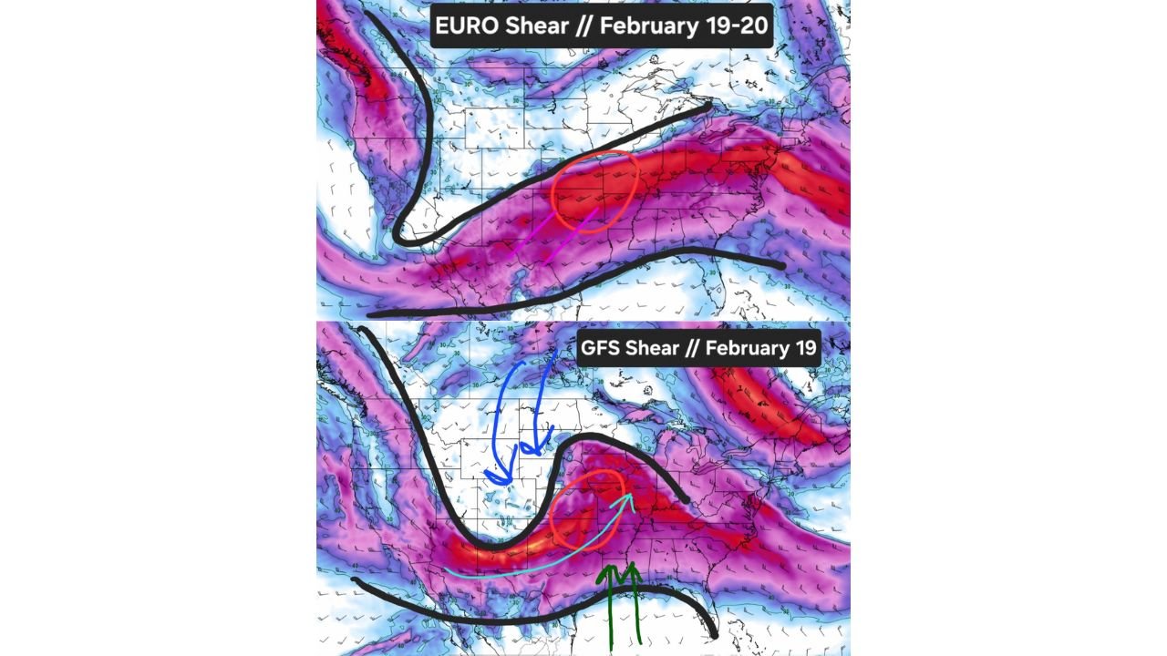
GFS Shows Classic Plains Severe Setup on February 19
The latest GFS shear map for February 19 displays a pronounced corridor of strong upper-level wind shear extending from Texas and Oklahoma through Arkansas, Missouri, Kentucky, and into parts of the Ohio Valley. The setup resembles a textbook early-season severe weather pattern.
Key ingredients shown in the model include:
- Strong wind shear aloft
- A warm, moist air mass surging north from the Gulf of Mexico
- Colder air advancing from the west
- A developing trough across the western United States
When warm, moist air collides with cooler air under strong wind shear, it can create an environment favorable for organized thunderstorms, including potential supercells.
The GFS depiction shows the most intense shear centered over portions of Oklahoma, Arkansas, southern Missouri, and western Kentucky, suggesting the warm sector of the storm system would extend into the lower Midwest.
EURO Extends Threat into February 19–20
The EURO (ECMWF) shear guidance for February 19–20 also indicates a broad swath of strong upper-level wind energy stretching from Texas across the Deep South and into Tennessee, Kentucky, and the central Appalachians.
While the EURO setup appears somewhat more elongated and slightly shifted, it similarly emphasizes a strong jet stream configuration. The shear axis aligns along a boundary separating colder northern air from warmer southern air — a classic springlike pattern appearing unusually early in the season.
The EURO guidance suggests the system could persist into February 20, potentially expanding storm chances farther east if the system remains organized.
Plains to Ohio Valley in the Warm Sector
Both model depictions highlight the warm sector of the Plains and Ohio Valley as the primary concern zone. This includes:
- Eastern Texas
- Oklahoma
- Arkansas
- Missouri
- Kentucky
- Parts of Tennessee and southern Illinois
In these areas, strong shear combined with sufficient surface moisture could support severe thunderstorms if instability develops.
However, forecasters emphasize that this remains a conditional threat. Shear alone does not guarantee severe weather; surface temperatures, moisture return, and storm timing will determine the ultimate outcome.
How This Could Affect the Midwest
For parts of the Midwest, including southern Illinois and surrounding states, the evolution of the storm track will be critical. If the system trends farther north, stronger storms could approach portions of the lower Midwest. If it remains more southern, impacts may stay focused closer to the Gulf states and Tennessee Valley.
The western United States also plays a role. Model maps show a pronounced trough dipping across California and the Southwest, helping to energize the downstream jet stream and strengthen shear across the central U.S.
Small shifts in this upper-level pattern could significantly alter the severe risk zone over the next several days.
Too Early for Specific Warnings — But Worth Monitoring
At this range, meteorologists are not issuing specific severe alerts. Instead, they are highlighting a pattern that bears watching. February severe weather events are not unheard of, especially across the southern Plains and lower Mississippi Valley, but the alignment of shear and moisture this far north would be notable for mid-to-late February.
Forecast confidence will improve as additional model runs refine storm timing and instability details. Ensemble guidance in the coming days will help determine whether this system strengthens, weakens, or shifts geographically.
As the February 19–20 timeframe approaches, residents across the Plains, Ohio Valley, and parts of the Midwest should stay aware of forecast updates — especially those with outdoor travel or event plans. For continued weather tracking and regional impact updates, visit ChicagoMusicGuide.com.