
Flash Flood Threat Lingers Across Northeastern Kansas, Southeastern Nebraska, Southwestern Iowa and Northwestern Missouri as Saturated Ground and 1 to 3 Additional Inches of Rain Put Four States on Alert
KANSAS CITY, MO — The ground across a four-state corridor spanning northeastern Kansas, southeastern Nebraska, southwestern Iowa, and northwestern Missouri is already saturated — and more rain is on the way. A formal flash flood potential statement is now in effect for this region, warning that an additional 1 to 3 inches of rainfall is possible through the morning hours, falling on soil that has absorbed more than 36 hours of continuous precipitation and has little capacity left to handle more.
When saturated ground receives additional heavy rainfall, the water has nowhere to go. It runs off immediately into creeks, streams, roadway ditches, and low-lying areas, producing flash flooding that can develop faster than most residents expect and faster than emergency services can respond.
What the Data Is Showing
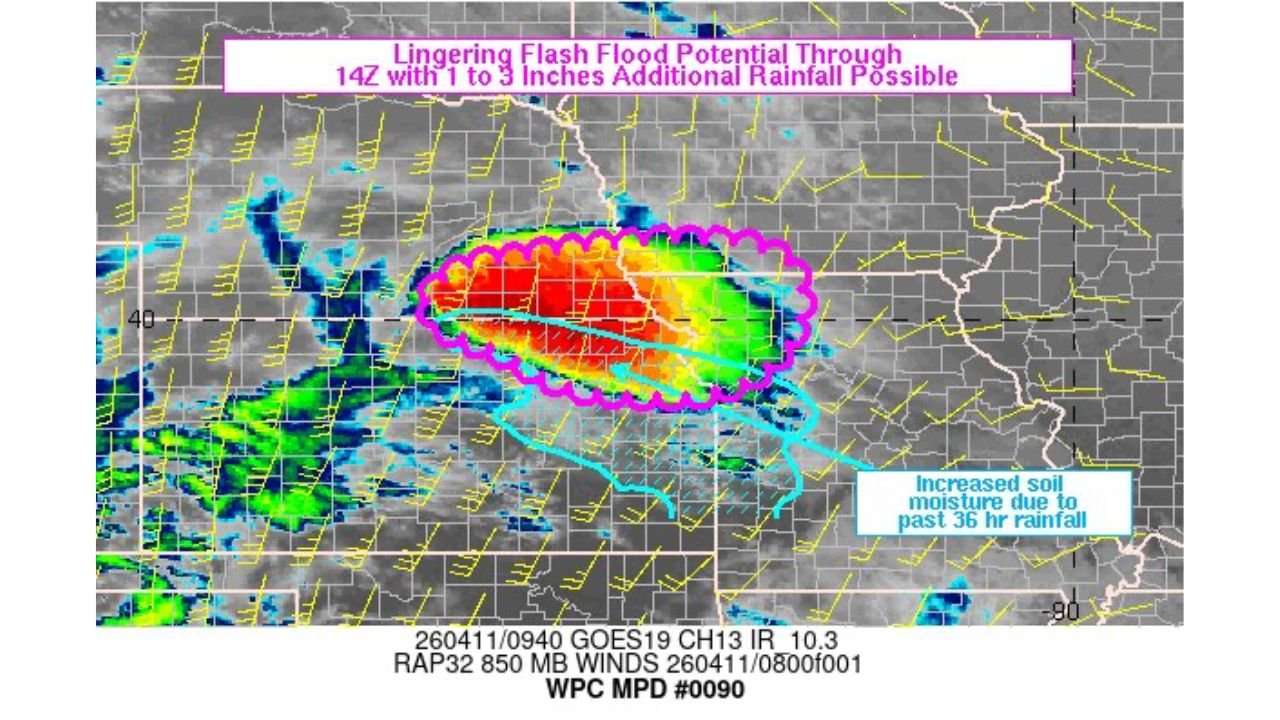
Current analysis confirms a concentrated area of intense rainfall — depicted in deep red and orange radar returns — is positioned across the northeastern Kansas and southeastern Nebraska corridor this morning. The storm system is organized and slow-moving, a combination that significantly increases rainfall totals over the same areas in a short period of time.
Two critical factors are compounding the threat today. First, soil moisture across the affected zone is already at or near saturation from the past 36 hours of rainfall — meaning the ground is functioning like a wet sponge that cannot absorb another drop. Second, the additional 1 to 3 inches of rainfall still expected through 14Z — approximately 9:00 AM local time — will fall entirely as runoff rather than being absorbed into the ground.
The combination of these two factors is precisely the scenario that produces the most dangerous and rapid flash flooding events.
Rainfall and Flash Flood Data Summary
| Factor | Detail |
|---|---|
| Additional Rainfall Expected | 1 to 3 inches |
| Flash Flood Potential Window | Through 14Z (approximately 9 AM local) |
| Soil Condition | Saturated — increased moisture from past 36 hours |
| Primary Threat | Rapid runoff, creek and stream flooding, road flooding |
| States Affected | Kansas, Nebraska, Iowa, Missouri |
| Formal Statement | WPC Mesoscale Precipitation Discussion 0090 |
State-by-State Flash Flood Breakdown
Kansas — Northeastern Counties The core of the heaviest rainfall is positioned across northeastern Kansas, where the most intense radar returns are concentrated this morning. Soil saturation from the prior 36-hour rainfall event is highest in this zone. Creek and stream flooding, road washouts on rural highways, and flash flooding of low-water crossings are the primary concerns. Residents across northeastern Kansas communities should avoid any travel across flooded roadways this morning regardless of how shallow the water appears.
Nebraska — Southeastern Counties Southeastern Nebraska sits within the active rainfall corridor and shares the same saturated soil profile as the Kansas counties directly to the south. Additional rainfall of 1 to 3 inches falling on already-maxed-out ground will push local waterways above their banks quickly. Low-lying neighborhoods near creeks and rivers in southeastern Nebraska should be prepared for rapid water rises through the morning.
Iowa — Southwestern Counties Southwestern Iowa is included in the flash flood potential zone, with increased soil moisture from the past day and a half of rainfall leaving little margin before additional rain produces surface runoff and flooding. Morning commuters across southwestern Iowa should check road conditions before traveling and treat any water across roadways as impassable.
Missouri — Northwestern Counties Northwestern Missouri, including communities in the Kansas City metro fringe, falls within the outer edge of the flash flood potential zone. The soil moisture enhancement from prior rainfall extends into this area, and any training storm cells — meaning storms that repeatedly move over the same location — could push localized totals above what drainage infrastructure can handle through the morning hours.
Forecast Confidence
Forecast Confidence: High for continued flash flood potential through the morning hours across all four states. The saturated soil condition is a confirmed and measured reality across the corridor, not a forecast assumption. The additional 1 to 3 inch rainfall total is well-supported by current radar trends and short-range model guidance. The primary uncertainty is the exact distribution of the heaviest rainfall totals within the broader zone — some communities will receive closer to 1 inch while others may approach the 3-inch upper end of the range, and those locations face the highest flash flood risk of the morning.
Do not drive through flooded roads. Turn around and find an alternate route. No destination is worth the risk of driving into floodwater that may be deeper or faster-moving than it appears from the road surface.
More flash flood and heavy rainfall coverage is always on the horizon. Stay informed at ChicagoMusicGuide.com — your source for flood threat tracking across Kansas, Nebraska, Iowa, Missouri, and the entire United States.