
Flash Flooding Threat Builds Overnight for Illinois and Indiana as Heavy Rain and Thunderstorms Converge Toward Indianapolis and Springfield by 10 PM Tuesday
INDIANAPOLIS, IN — The severe weather is done — but the danger is not over. As the last of Tuesday evening’s severe thunderstorms push out of Ohio, a new and potentially more insidious threat is already organizing across Illinois and Indiana: a converging mass of heavy rain and general thunderstorms tracking eastward through the overnight hours, setting the stage for flash flooding across the region by Wednesday morning.
This is the part of a multi-storm event that catches people off guard. The dramatic rotating storms and tornado warnings grab headlines, but the slow, relentless heavy rain that follows can fill creeks, overwhelm storm drains, and turn road underpasses into water traps before most residents realize the danger has shifted.
What Is Happening Right Now and What Comes Next
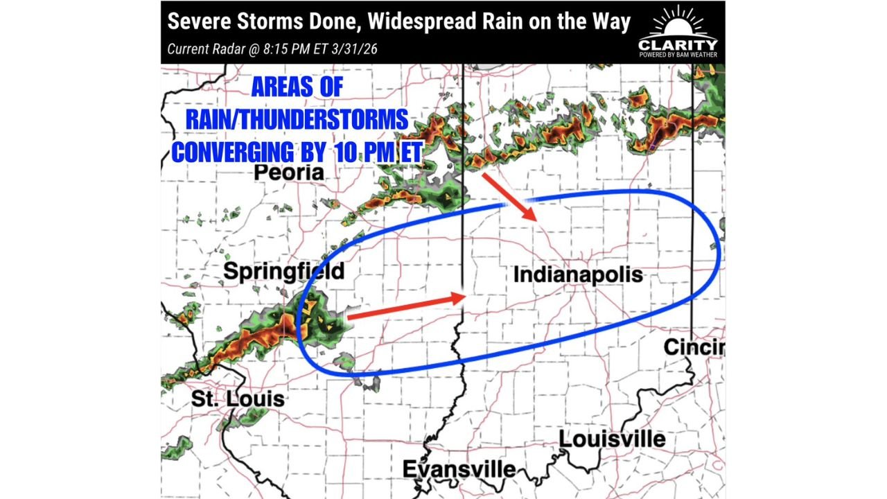
As of 8:15 PM Tuesday evening, current radar shows two distinct areas of rain and thunderstorm activity positioned west of the primary convergence zone and moving steadily eastward. One band is located near Springfield, Illinois and the St. Louis corridor, tracking northeast. A second area of activity is pushing through the Peoria, Illinois corridor further north.
Current analysis indicates both of these rain and storm areas are expected to converge into a single, broader zone of heavy precipitation centered over the Springfield to Indianapolis corridor by approximately 10:00 PM ET Tuesday. Once that convergence occurs, the combined moisture output from multiple storm clusters moving into the same region creates the conditions necessary for flash flooding — a scenario where rainfall accumulates faster than the ground and drainage systems can absorb it.
The flash flooding threat is not tonight. It is Wednesday morning — when residents wake up, head to work, and encounter roads that collected hours of heavy rainfall overnight. Low-lying roads, creek crossings, and urban drainage corridors across central Illinois and central Indiana are the areas of highest concern.
The Shift From Severe to Flood Threat
| Phase | Status | Primary Threat | Affected States |
|---|---|---|---|
| Severe Storms | Ending/Done | Damaging winds, hail, tornadoes | Illinois, Indiana, Ohio (exiting) |
| Overnight Rain | Developing Now | Heavy rainfall accumulation | Illinois, Indiana |
| 10 PM Convergence | Imminent | Rain/thunderstorm bands merging | Springfield IL to Indianapolis IN |
| Wednesday Morning | Flash Flood Potential | Flooded roads, rising creeks | Central Illinois, Central Indiana |
State-by-State Overnight and Wednesday Morning Outlook
🔴 Indiana (Central, Including Indianapolis Metro) — Highest overnight concern. The blue convergence zone on current radar analysis is centered directly over the Indianapolis corridor. Heavy rain bands moving in from the west will stack over this region through the overnight hours. Flash flooding of low-lying roads, underpasses, and urban drainage areas is the primary Wednesday morning hazard. Residents in Indianapolis and surrounding central Indiana communities should avoid driving through standing water Wednesday morning.
🔴 Illinois (Central, Including Springfield) — High concern. The Springfield area is at the western edge of the convergence zone and is already seeing active radar returns as of Tuesday evening. Overnight heavy rain accumulation across central Illinois raises flash flood potential for low-lying and flood-prone areas by early Wednesday morning.
🟠 Illinois (Northern, Including Peoria) — Elevated concern. The northern storm band tracking through the Peoria corridor will contribute to the overall moisture loading across the region overnight. Flash flooding potential exists across northern Illinois communities where drainage systems are already handling runoff from earlier severe weather activity.
🟠 Indiana (Southern, Including Evansville) — Elevated concern. The southern track of the converging rain bands keeps Evansville and southern Indiana in the heavy rainfall zone through the overnight hours. Low-lying areas and river corridors in southern Indiana should be monitored for rising water levels Wednesday morning.
🟡 Ohio (Western, Including Cincinnati Fringe) — Marginal concern. The eastern edge of the rain system will push toward Cincinnati and western Ohio overnight. Rainfall accumulation here will be less than the primary convergence zone, but localized heavy rain remains possible through the early morning hours.
🟡 Missouri (Eastern, Including St. Louis) — Marginal concern. The St. Louis area is positioned at the trailing western edge of the storm activity. Rain and thunderstorms are possible overnight but the heaviest activity is expected to push east of the metro by 10 PM.
🟢 Kentucky (Northern, Including Louisville) — Low concern overnight. Louisville sits south of the primary convergence zone. Isolated showers are possible but organized heavy rainfall is not expected to be widespread through Wednesday morning.
Forecast Confidence
Forecast Confidence: Moderate to High for overnight heavy rain convergence and Wednesday morning flash flooding potential across central Illinois and central Indiana. The eastward storm motion is consistent and well-established, and the convergence of multiple rain bands into the Springfield to Indianapolis corridor by 10 PM is well-supported by current radar trends.
The primary uncertainty involves exactly how much total rainfall accumulates before the system pushes through. If the rain bands slow their eastward movement or train repeatedly over the same areas — meaning storm after storm follows the same path — the flash flooding potential increases significantly above baseline expectations. Conversely, if the system accelerates and moves through more quickly than projected, totals may stay below flooding thresholds.
The most important safety message for tonight and Wednesday morning is simple: do not drive through flooded roads. Flash flooding kills more people in the United States each year than tornadoes. Six inches of moving water can knock a person off their feet. Twelve inches of water can carry a small vehicle. If you encounter a flooded road Wednesday morning, turn around — the risk is never worth it.
More overnight storm and flash flood coverage is always on the horizon. Stay informed at ChicagoMusicGuide.com — your source for severe weather and flash flood tracking across Illinois, Indiana, and the entire United States.