
Florida Braces for 50–70+ MPH Wind Gusts as HRRR Model Flags Powerful Overnight Storm Threat Through Early Monday
UNITED STATES — A potent round of severe weather is lining up across Florida tonight into early Monday morning, and the latest high-resolution HRRR model is now highlighting the potential for strong, potentially damaging wind gusts across much of the peninsula, especially from the Panhandle through Central Florida.
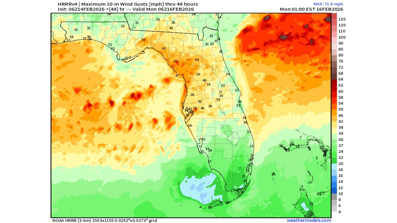
The newest guidance shows wind gust potential climbing into the 50–60 mph range across parts of North and Central Florida, with isolated pockets possibly pushing toward 70 mph, particularly offshore and along the Atlantic side. This system will move steadily through the state overnight, bringing a period of intense weather before gradually exiting by early Monday.
Strongest Gusts Target the Panhandle and Northern Florida
The HRRR maximum 10-meter wind gust projection through early Monday shows a broad swath of elevated wind speeds stretching from:
- Pensacola and Panama City
- Across Tallahassee
- Through Jacksonville
- Down toward Orlando and Tampa
Inland areas across North Florida are forecast to see gusts generally in the 45–60 mph range, while coastal and offshore zones, especially along the Atlantic waters, show higher-end gusts that could approach or exceed 70 mph.
The Panhandle appears particularly vulnerable to stronger wind cores embedded within the storm line. These gusts would be strong enough to:
- Down tree limbs
- Cause scattered power outages
- Create hazardous travel conditions on bridges and elevated roadways
Atlantic Side Showing Higher-End Wind Potential
One of the most notable features in the model output is the deep red shading offshore of Florida’s east coast, indicating a zone of stronger wind energy. While the highest gusts remain primarily offshore, coastal communities from:
- Jacksonville
- Down through Daytona Beach
- Toward Cape Canaveral
could still experience impactful wind, especially as the line of storms pushes east.
Even areas farther south, including Fort Myers and Miami, will see breezy conditions, though gusts there are projected to be lower compared to northern portions of the state.
Timing: Overnight Into Early Monday
The system progresses steadily south and east overnight:
- Panhandle & North Florida: Late evening into early overnight
- Central Florida (Orlando/Tampa): Around midnight to pre-dawn hours
- South Florida: Early Monday morning
By sunrise Monday, most of the severe wind threat should be shifting offshore, but breezy conditions may linger.
Storm Mode Favors Damaging Wind
While tornado potential cannot be completely ruled out with systems like this, the primary concern shown in the wind gust data is straight-line wind damage.
Linear storm structures often maximize forward momentum, allowing stronger winds aloft to mix down to the surface. With a fast-moving line, brief but intense wind bursts are possible.
The HRRR projection underscores that this is less about prolonged heavy rainfall and more about a quick but forceful push of wind energy through the state.
What This Means for Travel and Events
For Florida residents and anyone with travel or outdoor plans late Sunday into early Monday:
- Secure loose outdoor objects.
- Be cautious on highways, especially in high-profile vehicles.
- Expect possible scattered power disruptions in stronger wind zones.
This will not be an all-day event, but the overnight timing increases risk since many people may be asleep when the strongest winds move through.
Looking Ahead
Once this system exits, calmer conditions should gradually return Monday. However, as we move deeper into late winter and early spring, the pattern remains active across the Southeast.
Florida’s brush with severe weather this weekend is another reminder that the severe season can ramp up quickly — even before the traditional peak months.
We’ll continue monitoring updates and model trends closely.
Stay with ChicagoMusicGuide.com for the latest detailed storm breakdowns, regional impacts, and forecast updates as this system moves through Florida overnight.