
Florida Cold Records Fall Statewide as Three Straight February Mornings Shatter Daily Low Temperature Marks
FLORIDA — A rare and intense cold outbreak gripped Florida during the opening days of February, with record or near-record low temperatures reported statewide on Sunday, February 1, Monday, February 2, and Tuesday, February 3, according to preliminary data from the National Weather Service. Multiple observation sites across the peninsula tied or broke long-standing daily record lows as Arctic air pushed deep into the Southeast.
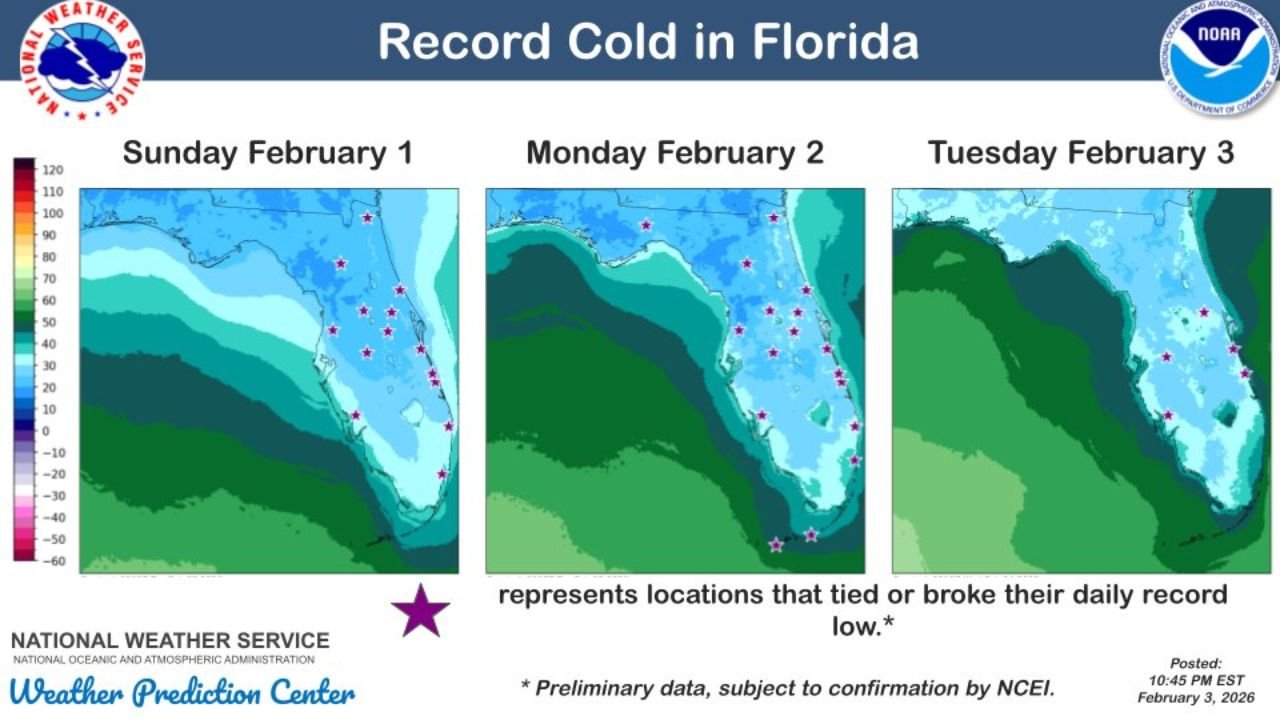
Three Consecutive Mornings of Record-Breaking Cold
Temperature maps from the Weather Prediction Center show widespread cold anomalies across North, Central, and South Florida over three consecutive mornings. Stars on the maps indicate locations that either tied or broke daily record low temperatures, highlighting how unusually cold this stretch was for early February standards in the Sunshine State.
On Sunday, February 1, record lows were most concentrated across North and Central Florida, where overnight temperatures dipped well below seasonal norms. The cold intensified further by Monday, February 2, with additional records falling as the cold air mass settled firmly over the region. By Tuesday, February 3, the chill persisted, extending record-cold conditions into parts of South Florida, an area where freezing or near-freezing temperatures are especially uncommon.
Statewide Impact From Panhandle to Peninsula
The cold was not limited to inland locations. Coastal areas also felt the effects, with temperatures falling low enough to challenge daily records along both the Gulf Coast and Atlantic Coast. While the coldest readings remained farther north, even typically mild regions experienced unusually chilly mornings.
Forecasters noted that this type of cold persistence is rare in Florida, particularly when records are challenged on three consecutive mornings. The prolonged nature of the cold increased impacts to sensitive vegetation, agriculture, and outdoor infrastructure, especially in regions unaccustomed to extended cold spells.
Why This Cold Event Was So Unusual
Florida winters can feature brief cold snaps, but this event stood out due to the strength of the Arctic air mass and its ability to push so far south. The lack of cloud cover and calm overnight winds allowed temperatures to drop efficiently, maximizing radiational cooling and leading to record-setting lows.
Preliminary data indicates that several records may still be subject to confirmation by climate analysts, but the spatial coverage of record indicators strongly suggests this cold event will rank among the more notable early-February cold outbreaks in recent years.
What Comes Next for Florida Weather
While moderation is expected later in the week, forecasters caution that winter is far from over. Florida remains vulnerable to additional cold intrusions through February, especially during periods of strong northern airflow. Residents are encouraged to continue monitoring forecasts and protecting cold-sensitive plants and property when temperatures dip unexpectedly.
For continued updates on extreme weather, record-breaking temperature trends, and regional forecasts across the country, visit ChicagoMusicGuide.com for the latest weather coverage and insights.