
Florida, Georgia, and the Southeast Brace for Another Arctic Cold Front as Sub-Freezing Temperatures Return Early Next Week
ORLANDO, FLORIDA — Another surge of Arctic cold air is expected to sweep into Florida and parts of Georgia late Sunday night into Monday morning, raising concerns for freeze warnings, agricultural impacts, and unusually cold morning lows across Central and North Florida. Forecast graphics and local meteorologist analysis indicate that sub-freezing air will push well down the I-75 corridor, marking yet another significant winter intrusion deep into the Southeast.
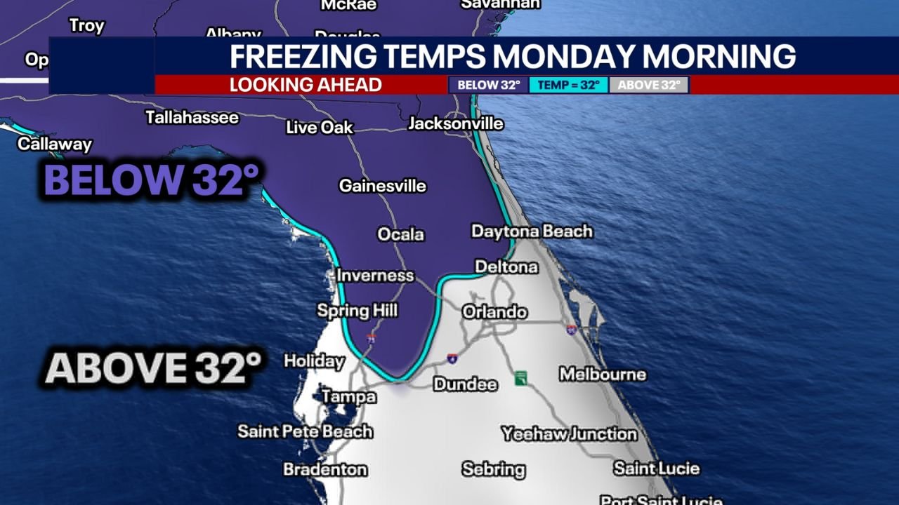
Another Arctic Front Targets Florida and Georgia
Meteorologists are tracking yet another Arctic cold front poised to arrive in Florida late Sunday night, with the coldest conditions settling in by early Monday morning. This system follows closely on the heels of previous cold outbreaks, reinforcing a persistent winter pattern that has allowed polar air to repeatedly plunge southward.
Forecast guidance shows below-freezing temperatures spreading across inland sections of North and Central Florida, while coastal areas remain slightly milder due to ocean influence. Portions of southern Georgia are also expected to experience freezing conditions as the cold air mass advances.
Freeze Warnings Likely Along the I-75 Corridor
The most widespread impacts are expected along the I-75 corridor, where sub-32°F temperatures are forecast to reach communities from Gainesville and Ocala southward toward Clermont and The Villages. Meteorologists note that freeze warnings are likely to be reissued for these areas as confidence grows in overnight lows dipping into the upper 20s.
Rural and inland locations are particularly vulnerable, where clear skies and calm winds could allow temperatures to drop rapidly before sunrise. These conditions pose risks to sensitive plants, exposed plumbing, and outdoor pets.
Central Florida Cold but Mostly Above Freezing
In the Orlando metro area, forecasts suggest temperatures should hover just above the freezing mark, generally in the mid-30s by Monday morning. While widespread frost is less likely in the urban core, nearby outlying areas could still see pockets of colder air, especially in low-lying locations.
Farther east toward the coast — including Daytona Beach, Titusville, and Cocoa Beach — lows are expected to remain in the upper 30s to lower 40s, limiting freeze impacts but still delivering a sharp reminder of winter’s presence in Florida.
Why This Cold Surge Is Unusual for Late January
Repeated Arctic intrusions into Florida and the Deep South are uncommon, especially when they occur in quick succession. Forecasters point to a persistent upper-level pattern that continues to funnel cold Canadian air southward, overriding typical late-January moderation.
This setup increases the likelihood of multiple freeze events, which can be more damaging than a single cold night due to cumulative stress on vegetation, infrastructure, and energy demand.
What Residents Should Prepare For
Residents across Florida and southern Georgia are urged to prepare for another cold morning, particularly those in freeze-prone inland areas. Protecting plants, bringing pets indoors, and ensuring outdoor pipes are insulated can help reduce impacts.
While no winter precipitation is expected with this system, the temperature drop alone is enough to cause disruptions, especially for agriculture and early-morning travel.
As winter continues to make its presence felt across the Southeast, staying informed will be essential. For ongoing updates on cold fronts, freeze risks, and winter weather trends affecting Florida and beyond, visit ChicagoMusicGuide.com for the latest weather coverage.