
Florida’s Extreme Drought Crisis Deepens as 70% of State Falls Into Severe to Extreme Category, Scattered Downpours Thursday May Bring Limited Relief
FLORIDA — Nearly the entire state is now entrenched in drought conditions, with roughly 70% of Florida classified in severe to extreme drought, according to the latest U.S. Drought Monitor data. While scattered downpours are expected Thursday afternoon and evening, forecasters caution that the rainfall will only chip away at what has become a deepening statewide moisture deficit.
Drought Covers Almost the Entire State
The latest drought map shows widespread D3 (Extreme Drought) conditions dominating:
- The Florida Panhandle
- Much of North Florida
- Large portions of Southwest Florida
- Parts of Central Florida
Areas around Tampa, Sarasota, Fort Myers, Naples, Orlando, and Tallahassee are all impacted at varying intensities. Only small pockets in central sections show slightly lower drought classifications.
Meanwhile, contrast is stark across the country — California is currently drought-free, underscoring how concentrated the crisis is across the Florida peninsula.
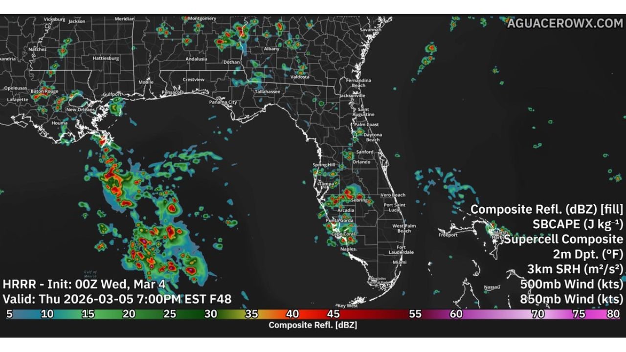
Where Thursday’s Downpours Are Most Likely
High-resolution model guidance valid Thursday evening shows scattered thunderstorms developing across:
- Southwest Florida, including Fort Myers, Naples, and Port Charlotte
- Interior zones near Arcadia and Sebring
- Parts of Central Florida, including areas south of Orlando
- Isolated activity near Tampa and Spring Hill
Radar simulation imagery suggests clusters of moderate to heavy downpours over the Gulf waters pushing inland during the afternoon and early evening hours.
However, rainfall coverage appears scattered rather than widespread — meaning some communities could see brief heavy rain while others remain dry.
Will It Be Enough? Probably Not Yet
Even where storms develop, rainfall amounts are unlikely to fully reverse drought impacts in one round.
Extreme drought typically requires:
- Multiple widespread rain events
- Slow-moving systems
- Deep, soaking rainfall over several days
Thursday’s pattern favors convective pop-up storms rather than an organized, soaking rain shield.
That means improvement may begin in localized areas, but the broader drought footprint will likely persist.
Wildfire and Lightning Concerns
Another concern is lightning without sufficient rainfall. In extremely dry conditions, lightning strikes that produce minimal precipitation can ignite brush fires.
With much of the state’s vegetation stressed and soils parched, forecasters are watching for any dry thunderstorm scenarios — particularly in interior sections.
Why This Matters Beyond Agriculture
Drought impacts in Florida extend beyond farming. Effects include:
- Lower lake and reservoir levels
- Increased wildfire risk
- Stress on municipal water supplies
- Ecological strain on wetlands and coastal systems
With spring approaching, sustained rainfall will be critical to prevent further deterioration.
What Happens Next
Models indicate scattered rain chances Thursday, but long-term drought improvement will depend on whether Florida transitions into a more active wet pattern in the coming weeks.
Until then, residents across Tampa Bay, Orlando, Fort Myers, Naples, and the Panhandle remain under significant drought stress.
ChicagoMusicGuide.com will continue tracking major weather developments across the country as this evolving Florida drought story unfolds.