
Forecast Uncertainty Looms Over Washington D.C. as Competing Weather Models Show Major Temperature Divide for Friday
WASHINGTON, D.C. — Meteorologists are facing a challenging temperature forecast for the Washington D.C. metropolitan area on Friday, as uncertainty surrounding the exact placement of a nearby weather front could dramatically influence temperatures across the region.
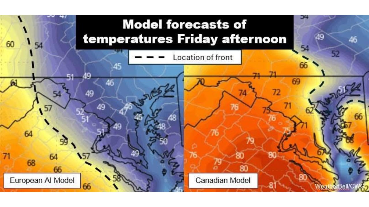
Current model guidance suggests that a boundary separating two very different air masses may sit near the D.C. area, creating a sharp temperature contrast depending on which side of the front communities end up on.
North and east of the boundary, much cooler air could dominate, while areas to the south and west may experience significantly warmer springlike temperatures.
Cooler Air Could Hold Strong North and East of the Front
Some forecast models indicate that the cooler air mass may remain entrenched across portions of the District of Columbia, Maryland, and northern Virginia.
In this scenario, temperatures Friday afternoon could struggle to climb above the upper 40s to low 50s, particularly in areas north and east of Washington, D.C., including:
- Baltimore, Maryland
- Southern Pennsylvania
- Parts of northern Maryland
- Areas near the Chesapeake Bay
Cooler air masses like this often prove stubborn, especially when reinforced by persistent cloud cover and northeasterly winds.
Meteorologists note that weather models sometimes underestimate how long cooler air can linger, particularly in early spring setups.
Alternate Scenario Brings Much Warmer Temperatures
A competing forecast scenario suggests that the frontal boundary could shift farther north, allowing warmer air to spread across much of the region.
Under that solution, areas across the southern and western portions of the D.C. metro area could see temperatures rise near or even above 70 degrees Friday afternoon.
Warmer conditions would likely impact communities including:
- Northern Virginia
- Fredericksburg
- Parts of central Virginia
- Areas west of Washington toward the Shenandoah Valley
The warmer air mass would be fueled by southerly winds drawing milder air northward ahead of the front.
Most Likely Outcome Falls Between the Two Extremes
Forecasters say that when models diverge this dramatically, the actual outcome often falls somewhere between the two scenarios.
At this point, meteorologists are leaning toward afternoon highs generally ranging from the 50s to the 60s across the region, with a noticeable gradient depending on location.
Under the current thinking:
- Cooler temperatures are more likely north and east of Washington, D.C.
- Warmer conditions will likely be found south and west of the city
Even small shifts in the frontal boundary — sometimes just 20 to 30 miles — could make a major difference in how warm or cool it feels across the metropolitan area.
Forecast Confidence Expected to Improve Soon
Meteorologists expect that forecast confidence should increase within the next 24 hours as newer model runs provide better clarity on the position of the front.
As the event approaches, updated guidance will help determine whether the cooler air holds firm or if warmer spring temperatures manage to push farther north.
For residents across the D.C., Maryland, and northern Virginia region, Friday’s forecast remains a classic early spring setup where small shifts in weather patterns could lead to large temperature swings.
For more weather updates and regional forecasts across the United States, visit ChicagoMusicGuide.com.