
Forecasters Compare Sunday–Monday Setup to April 4–5, 2011 as Powerful Trough Targets Mississippi, Alabama, Tennessee and Georgia With Widespread Severe Threat
BIRMINGHAM, ALABAMA — Meteorologists are beginning to draw comparisons between the upcoming Sunday–Monday severe weather setup and the highly prolific April 4–5, 2011 event — not necessarily for a historic tornado outbreak, but for the potential scale and organization of severe reports across the South and Mid-South.
While it remains too early to determine exact impacts, the evolving pattern features a deep, negatively tilted trough and an unusually strong jet stream configuration that could support widespread severe thunderstorms from Mississippi and Alabama through Tennessee and into Georgia.
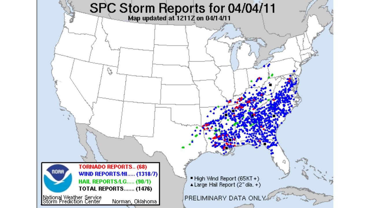
Looking Back at April 4–5, 2011
The April 2011 event produced one of the most prolific days of severe weather reports on record across the Southeast. On April 4, 2011 alone, storm reports included:
- Dozens of tornado reports
- Over a thousand wind damage reports
- Numerous hail reports
The upper-level pattern at that time featured a powerful trough digging into the Deep South with intense mid-level winds overspreading a moisture-rich warm sector — a configuration that allowed storms to organize efficiently across a broad region.
Similar Upper-Level Dynamics Emerging
Forecast charts for the upcoming Sunday–Monday period show a similarly strong trough carving into the central United States and pivoting eastward.
A pronounced jet streak is projected to arc from the Southern Plains into the Lower Mississippi Valley and Tennessee Valley, placing areas such as:
- Jackson, Mississippi
- Birmingham, Alabama
- Nashville, Tennessee
- Memphis, Tennessee
- Atlanta, Georgia
within a corridor of enhanced wind energy aloft.
This setup can favor organized storm structures capable of producing multiple hazards if sufficient instability develops ahead of the front.
Broad Severe Risk Area Across the Southeast
Outlook projections indicate the core severe threat zone may stretch from central Mississippi through northern Alabama and into central Tennessee, with risk contours extending into parts of Georgia and possibly western portions of the Carolinas depending on timing.
The analog comparison highlights a central corridor similar to past high-end events, where overlapping wind shear and moisture can maximize storm coverage and intensity.
All Hazards Remain Possible
If current trends hold, potential threats could include:
- Widespread damaging wind gusts
- Large hail
- Tornadoes, including the possibility of strong tornadoes if discrete supercells develop
However, forecasters stress that subtle changes in trough orientation, timing, and moisture return could significantly enhance or reduce the tornado threat.
A faster-moving system might limit instability. A slower progression with deeper moisture could raise concerns.
Still Days Away
Despite the striking similarities in upper-level structure, this event remains several days out. Forecast confidence will increase as shorter-range models begin resolving mesoscale details.
Residents across Mississippi, Alabama, Tennessee, and Georgia should stay alert as the weekend approaches and forecast refinements continue.
While comparisons to April 2011 highlight the seriousness of the setup, the exact magnitude of this event will depend on evolving atmospheric details.
For continuing updates on this developing severe weather pattern, stay with ChicagoMusicGuide.com.