
Georgia, Alabama, and South Carolina Face Limited Sunday Snow Risk as Rain Transitions Briefly to Wintry Mix
UNITED STATES — Georgia, Alabama, and South Carolina are tracking a weak winter weather system expected to move through the Southeast from late Saturday night into Sunday, bringing mostly rain with brief periods of snow or rain-snow mix, mainly west of the I-95 corridor. Forecast confidence has increased, but meteorologists emphasize that impacts will be limited, with little to no meaningful accumulation expected.
While snow has drawn attention across social media, updated guidance from National Weather Service offices in Atlanta and Charleston shows that this event is not a significant winter storm, especially for coastal areas and major roadways.
What the Forecast Shows for Georgia, Alabama, and South Carolina
Forecast data indicates a surface wave moving along a cold front across the northern Gulf and Southeast early Sunday. This system will introduce rain across much of southern Alabama, central and eastern Georgia, and coastal South Carolina, with colder air filtering in from the north during the morning hours.
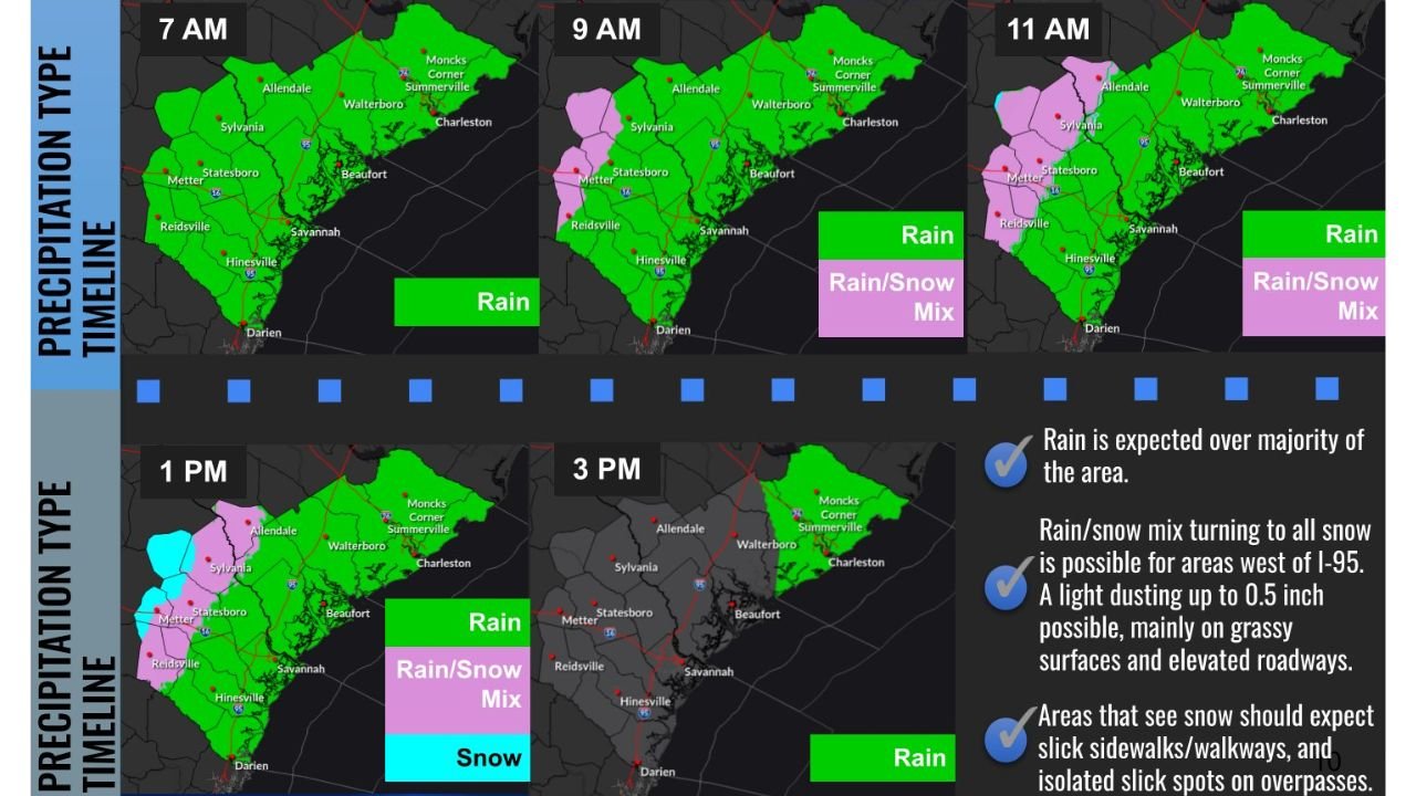
As temperatures fall into the mid-30s, rain may briefly change to light snow or a rain-snow mix, particularly across central Georgia, inland South Carolina, and southeastern Alabama. Snow chances increase west of I-95, where probabilities for measurable snowfall range from 40–50 percent.
Despite these probabilities, accumulation potential remains low, generally up to 0.5 inches, mainly on grassy surfaces and elevated roadways.
Timing and Areas Most Likely to See Snow
The timeline shows precipitation developing near daybreak Sunday, continuing through early afternoon. Model agreement remains strong on timing, increasing confidence in the forecast.
- Morning: Rain dominates across most areas
- Late morning to midday: Rain may briefly mix with or change to snow inland
- Early afternoon: Precipitation tapers off from west to east
Snow chances are highest across inland South Carolina counties, portions of central Georgia, and southeastern Alabama near Dothan, where rain could briefly flip to snow as colder air deepens.
Expected Impacts Remain Minimal
Meteorologists stress that surface temperatures and warm ground conditions will limit accumulation. Even in areas that see snow, roads are expected to remain mostly wet, not snow-covered.
Potential impacts include:
- Slower travel during periods of rain or mix
- Slick sidewalks and walkways
- Isolated slick spots on bridges and overpasses
Rapidly falling temperatures Sunday night could allow patchy black ice early Monday, though steady winds and lowering humidity may reduce widespread icing concerns.
Why Social Media Snow Maps Are Overstating the Threat
Forecast officials continue to caution against viral “snow maps” circulating online that show 6–8 inches of snow across the Deep South. These maps often reflect raw model output without accounting for atmospheric limitations, surface temperatures, or model bias.
Professional forecasters emphasize that numerical weather models must be interpreted, not posted blindly. Current guidance does not support a historic winter storm, and confidence remains high that this system will produce only minor winter effects.
What Comes Next for Winter Weather
While this weekend’s system is modest, winter is far from over. Meteorologists note that some of the Southeast’s most impactful snow events historically occur in late February, March, or even early April.
Snow lovers may still have opportunities later this season, but Sunday’s event is not the one many online sources have advertised.
For continued accurate, data-based weather updates across the Midwest and beyond, visit ChicagoMusicGuide.com, where we break down forecasts without hype and focus on what truly impacts communities.