
Georgia, South Carolina, and North Carolina Face Isolated Severe Storm Threat as Cold Air Aloft Fuels Hail Risk Saturday Evening
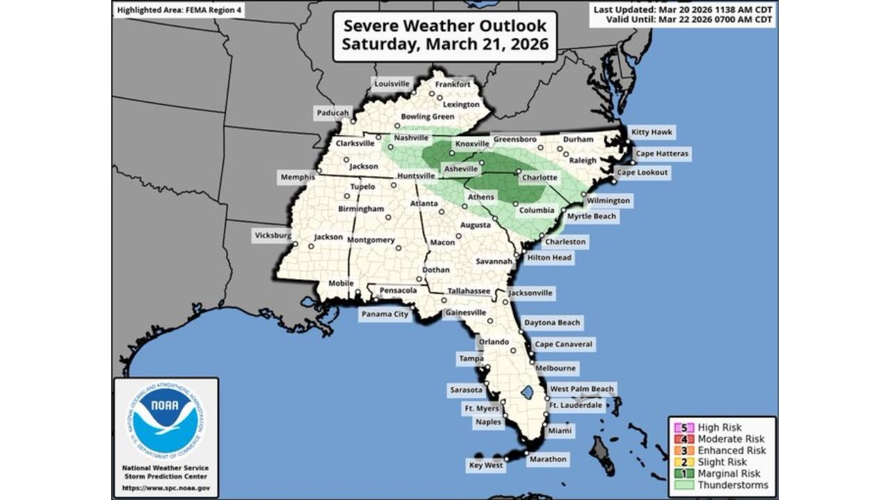
ATLANTA, GEORGIA — A developing shortwave system is expected to bring isolated strong to severe storms across parts of the Southeast, particularly impacting Georgia, South Carolina, and North Carolina on Saturday afternoon and evening, March 21, 2026. Forecasters highlight a hail threat driven by unusually cold air aloft, even as overall moisture remains limited.
The setup is not widespread, but meteorologists warn that any storm that forms could quickly intensify due to favorable atmospheric conditions. Areas including Atlanta, Columbia, Charlotte, and surrounding regions are under a marginal to slight risk zone, according to the latest Severe Weather Outlook.
Cold Air Aloft and Lapse Rates Driving Storm Development
The key factor behind this setup is the presence of cold air in the upper atmosphere, which is creating steep lapse rates — a rapid decrease in temperature with height. This condition enhances instability, even in environments where surface humidity is not particularly high.
Meteorologists explain that when storms develop in these conditions, they can become more vertically intense. This leads to increased CAPE (Convective Available Potential Energy), often referred to as storm fuel, allowing storms to strengthen rapidly despite limited moisture.
Across parts of Georgia and the Carolinas, this dynamic is expected to peak during the late afternoon into the evening hours. While the coverage of storms will remain isolated, any storm that does form has the potential to produce hail due to strong updrafts and colder upper-level temperatures.
High-Resolution Models Show Scattered Storm Clusters
Short-range forecast models, including high-resolution reflectivity guidance, indicate scattered clusters of thunderstorms developing primarily over central and eastern Georgia, then tracking northeast into South Carolina and North Carolina.
Simulated radar imagery suggests that storms could briefly organize into small clusters, especially near areas like Augusta, Columbia, and Charlotte. These clusters may not last long but could produce bursts of heavy rain, lightning, and hail.
Importantly, the storm coverage remains hit-or-miss, meaning many areas may stay completely dry while others experience sudden, intense weather. This type of pattern makes it difficult to pinpoint exact locations of impact, increasing the element of surprise for residents.
Low Humidity but Elevated Severe Potential
Despite the presence of storms, dew point temperatures across much of the region remain relatively low, generally in the 40s to low 50s. Normally, such conditions would limit severe weather potential, but in this case, the cold air aloft compensates for the lack of moisture.
This unusual combination creates a setup where storms may not look particularly threatening at first but can quickly produce strong updrafts capable of generating hail. Forecasters emphasize that this is a classic low-humidity severe weather setup, where instability is driven more by temperature differences than moisture.
Areas in northern Georgia, upstate South Carolina, and western North Carolina are particularly favored for this type of environment, where terrain and atmospheric dynamics can further enhance storm development.
What Residents Should Expect Saturday Evening
Residents across Georgia, South Carolina, and North Carolina should remain alert during the late afternoon and evening hours. While not everyone will see storms, those who do could experience brief but intense weather conditions.
Potential impacts include:
- Hail, possibly small to moderate in size
- Frequent lightning
- Short bursts of heavy rain
- Gusty winds in isolated storms
Because storms will be isolated, there will be significant variability in conditions even within short distances. One neighborhood may remain calm while another sees a sudden storm develop overhead.
Forecasters advise keeping an eye on radar and staying weather-aware, especially if outdoor plans are scheduled during the evening hours.
As this evolving Southeast storm pattern continues to develop, staying informed is critical. For more updates on severe weather alerts, regional forecasts, and detailed breakdowns of storm risks across the United States, visit ChicagoMusicGuide.com.