
Georgia, South Carolina, North Carolina and Florida Face Uncertain Winter Storm and Arctic Cold Threat This Weekend
Atlanta, Georgia — Meteorologists are closely monitoring a developing winter weather threat that could impact Georgia, South Carolina, North Carolina, and Florida from Saturday night through Sunday, while a powerful Arctic blast simultaneously pushes dangerously cold air across much of the United States. Forecast confidence remains low, but multiple model updates suggest a growing risk for light snow, wintry mix, and sharply colder temperatures across the Southeast.
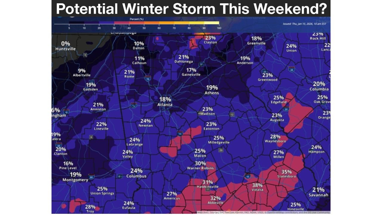
Georgia and South Carolina Snow and Wintry Mix Potential
Forecast data shows a cold front moving through the Southeast late Friday into Saturday, bringing rain showers followed by colder air. A second system is expected to approach Saturday night into Sunday, creating the possibility of snow or a rain-to-snow transition, particularly across central and northern Georgia and western portions of South Carolina.
Probability graphics indicate a 15–30% chance of at least ½ inch of snow in parts of Georgia, with some localized areas potentially seeing slightly higher totals if colder air deepens faster than expected. In South Carolina, areas west of Interstate 95 have the highest chance of seeing wet snow or a wintry mix, while coastal regions are more likely to experience mainly rain with occasional flakes mixing in.
North Carolina Forecast Focused Between I-85 and I-95
In North Carolina, forecasters are focusing on the corridor between Interstate 85 and Interstate 95, where temperatures may be just cold enough to support light snow or a wintry mix late Saturday night. East of I-95, including coastal communities, precipitation is expected to fall primarily as rain, though brief periods of wet snow or sleet cannot be ruled out if colder air arrives sooner than anticipated.
Even where snow develops, accumulations are expected to be light, as ground temperatures remain relatively mild and surface temperatures may hover near or above freezing for much of the event.
Florida Flurries Possible as System Slides South
While Florida is unlikely to see widespread winter impacts, forecast imagery highlights an unusual scenario where flurries or snow showers could reach northern Florida, including areas near Tallahassee, late Sunday. In a low-probability but notable outcome, localized slushy accumulation could occur if precipitation overlaps with colder air. Forecasters emphasize this remains an outside chance, but it underscores the strength of the cold air mass involved.
Arctic Blast Brings Dangerous Cold to the Midwest and Central U.S.
Beyond the Southeast storm setup, a significant Arctic air outbreak is expected to surge southward this weekend. Temperature anomaly maps show the core of this cold settling over the Midwest, where wind chills could plunge to near −30°F by Monday morning. This Arctic blast will increase risks of frostbite, frozen pipes, and hazardous travel across large portions of the central United States.
The southern reach of this cold air will play a critical role in determining how much wintry precipitation reaches Georgia, South Carolina, and North Carolina.
What Residents Across the Southeast Should Do Now
With forecast confidence still very low, residents across Georgia, South Carolina, North Carolina, and Florida are urged to stay alert and prepared for changes. This is a good time to review winter safety plans, monitor forecast updates, and plan for possible travel impacts late Saturday and Sunday. Even minor snow or ice can cause slick roads in regions not accustomed to winter weather.
ChicagoMusicGuide.com will continue tracking this evolving winter setup and its potential impacts across the Southeast and beyond. Stay connected for the latest weather updates, safety information, and regional outlooks as confidence improves.