
Great Lakes, Northeast and Northern Plains Set for Clipper Parade While Southern U.S. Warms Through Late March With No Major Severe Threat in Sight
UNITED STATES — After a powerful storm system swept across parts of the country earlier this week, the atmosphere is shifting into a quieter and more stable late-March pattern. Forecast models show a largely zonal jet stream, meaning weather systems will move quickly west to east, with no dominant storm threatening the Lower 48 in the immediate future.
Instead of major cyclones or widespread severe weather, the focus turns to a series of fast-moving clipper systems targeting the Northern Plains, Great Lakes, and Northeast.
Zonal Flow Keeps Big Storms at Bay
Upper-level pattern analysis shows the jet stream running mostly straight across the country, with stronger troughing locked up across northern Canada.
That setup typically results in:
- Quick-moving disturbances
- Limited moisture return
- Modest temperature swings
- Few large-scale storm outbreaks
The flow remains “bottled up” farther north, preventing deep southern troughs from digging into the central or eastern United States.
Clippers to Target Northern Plains and Great Lakes
Small dips in the northern jet will periodically slide southeast, producing Alberta-style clippers.
Regions most likely to see impacts include:
- North Dakota and Minnesota
- Wisconsin and Michigan
- Upstate New York
- Interior New England
These systems may bring:
- Light snow or rain showers
- Gusty winds
- Brief shots of cooler air
However, they are not expected to produce major snowstorms or significant severe weather.
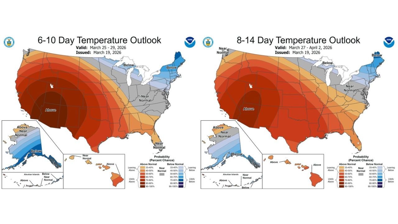
Southern and Western U.S. Trending Warmer
Temperature outlooks for the 6–10 day and 8–14 day periods strongly favor above-normal temperatures across:
- The Southwest
- Texas
- The Southern Plains
- Much of the Deep South
Warmth is projected to expand northward into parts of the central United States.
Meanwhile:
- The Northeast may trend near to below normal at times
- The Upper Midwest could experience periodic cool shots with passing clippers
Overall, the southern half of the country looks primed for sustained late-season warmth.
No Significant Severe Weather Pattern Emerging
One of the more notable aspects of the forecast is what is not present.
Current long-range guidance does not show:
- Strong southern trough digging into the Plains
- Deep Gulf moisture surging northward
- A classic severe weather setup
While isolated thunderstorms are always possible in late March, there is no clear signal supporting a widespread severe outbreak across the Lower 48 in the foreseeable future.
Forecasters note that patterns can shift as April approaches, but for now, the atmosphere lacks the ingredients for a major severe weather event.
Watching for a Potential 7–10 Day Trough Shift
There is some indication that a stronger trough could dig into the eastern United States in the 7–10 day window.
If that materializes, it could bring:
- A more noticeable cool-down for the Eastern U.S.
- Increased energy for a more organized weather system
- Enhanced precipitation potential
However, confidence remains moderate, and the overall pattern still favors relatively low-impact systems.
Quiet End to March for Much of the Country
In summary:
- Clippers will affect the Northern Plains, Great Lakes, and Northeast
- The Southern U.S. remains largely warm and stable
- No major severe weather pattern is evident
- A modest eastern cool-down is possible late in the period
After a stretch of active weather earlier in the month, the atmosphere appears to be entering a calmer phase as March winds down.
Stay with ChicagoMusicGuide.com for continuing updates on national weather trends as we head into April and the heart of spring.