
Great Lakes Region Wednesday Forecast Could Flip From Snow Concerns to Elevated Storm Threat Across Michigan, Indiana, Ohio
GREAT LAKES REGION — Forecast guidance is hinting at a notable midweek shift for parts of the Great Lakes, with a developing system that could trend far enough north to reduce snow potential and introduce a more unstable, storm-favorable setup by Wednesday. While confidence is still evolving, the overall theme is a possible transition from winter impacts to an elevated thunderstorm window if warm air can surge in above the surface.
Model signals shown in the latest maps suggest the storm track may keep pushing north, which would support snow melting and a warmer profile in key areas. That trend is still worth watching carefully, because even small track changes could determine whether the region deals with a wet, slushy system—or a more energetic round of mid-latitude convection.
What the Day 5 Severe Signal Is Suggesting Right Now
The CSU-MLP (FV3-GEFSO) Day 5 severe probability forecast highlights a broad area of concern centered on the Ohio Valley into the southern Great Lakes, with the highest shaded probabilities focused near the Indiana–Ohio–Michigan corridor. The map shows a maximum probability near 0.228, which is not a guarantee of severe weather—but it is a meaningful early flag that the environment could become supportive if the storm evolves as currently depicted.
This type of signal usually lines up with a few key ingredients coming together: a strengthening storm system, increasing wind energy aloft, and enough instability to allow thunderstorms to organize. Even at long range, it’s the kind of pattern that prompts forecasters to monitor trends closely—especially when the region is balancing between lingering winter cold and incoming spring-like warmth.
If the low continues to track north, the “warm side” of the storm would expand farther into the Great Lakes, increasing the likelihood that rain and thunderstorms become the dominant story for areas that might otherwise be expecting snow.
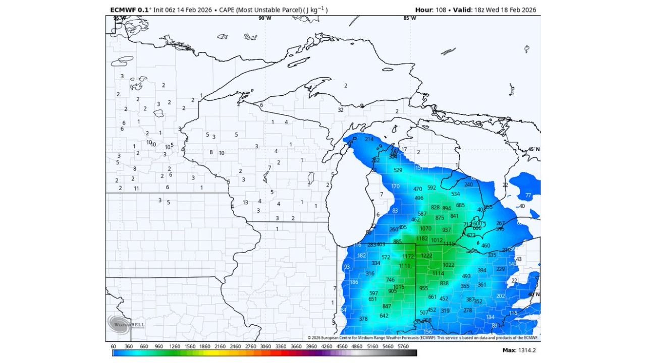
CAPE Map Points to a More Unstable Great Lakes Setup by Wednesday
One of the clearest signals in the data is the ECMWF CAPE (Most Unstable Parcel) forecast valid around 18z Wednesday (Feb. 18). The map shows expanding instability into the region, with Michigan, Indiana, and Ohio all included in the corridor of higher values. The strongest instability appears focused from Indiana into Ohio, where CAPE values climb notably higher than surrounding areas—an important detail if storms become surface-based or even partially rooted in the warm layer above the ground.
Meanwhile, parts of Lower Michigan also show meaningful CAPE, which raises the ceiling for thunderstorms if the system can pull enough moisture north. In colder seasons, “elevated” storms can still produce loud thunder, hail, and bursts of strong wind—even if temperatures near the ground stay cool.
The placement of the instability axis matters as much as the numbers themselves. If the storm track nudges north, the instability field may shift closer to the southern Great Lakes population centers, increasing the odds of impactful weather across more of Michigan and northern portions of Indiana and Ohio.
Why the Northward Storm Track Matters for Snow Melt and Storm Risk
The forecast discussion behind these maps points to guidance continuing to uptrend the low north, which would encourage more snow melting and reduce the footprint of accumulating snow. That is a major swing point for the Great Lakes in February: if surface temperatures rise and the warm layer deepens, the region moves away from classic winter impacts and into a setup where rain and convection can take over.
However, being skeptical of “majority snow melting” at this range is reasonable—especially in the Great Lakes, where cold air can be stubborn and lake-modified boundary layers can hold onto chill longer than models advertise. A colder-than-expected surface layer could still keep mixed precipitation in play, or limit how intense storms can get.
On the flip side, if warm air wins out aloft while the surface stays cool, that can actually favor elevated storms—a scenario where thunderstorms form above a stable layer near the ground. Those storms may not look like summer supercells, but they can still pack a punch, particularly with hail potential.
What to Watch Over the Next 48–72 Hours
As Wednesday approaches, the biggest forecast questions for the Great Lakes Region will come down to track, timing, and temperature profiles. Here are the key trendlines that will likely decide how the day plays out:
- Storm track: Does the low center remain on a north trend toward the southern Great Lakes, or does it shift south and reintroduce more snow risk?
- Thermal profile: Do Michigan, Indiana, and Ohio warm enough to support more widespread thunderstorms, or does cold air hang on near the surface?
- Instability placement: Does the higher CAPE axis remain centered over Indiana/Ohio, or expand deeper into Michigan?
- Severe potential consistency: Do day-to-day runs keep the CSU-MLP severe probabilities in the same corridor, or do they weaken/relocate?
If the trend holds, Wednesday could feature a classic late-winter surprise—where the Great Lakes goes from thinking about snowpack and slush to tracking thunder potential. Either way, the setup is one to monitor closely as higher-resolution guidance comes into range.
As the Great Lakes Region watches this midweek system come into focus, staying aware of changing conditions will be key for commuters, travelers, and anyone with plans across Michigan, Indiana, and Ohio. For continued weather updates that help you plan around shifting storm tracks, snow melt concerns, and thunderstorm risks, visit ChicagoMusicGuide.com.