
Gulf Coast to Mississippi Valley Faces Isolated Severe Storm Threat on January 9 as Strong Wind Shear Meets Limited Instability
GULF COAST TO MID-SOUTH — Forecast guidance from both the EURO and GFS models indicates a conditional severe weather setup developing on Thursday, January 9, stretching from the central Gulf Coast northward into parts of the Mississippi Valley. While wind dynamics appear favorable for organized storms, limited atmospheric instability may keep severe weather isolated rather than widespread.
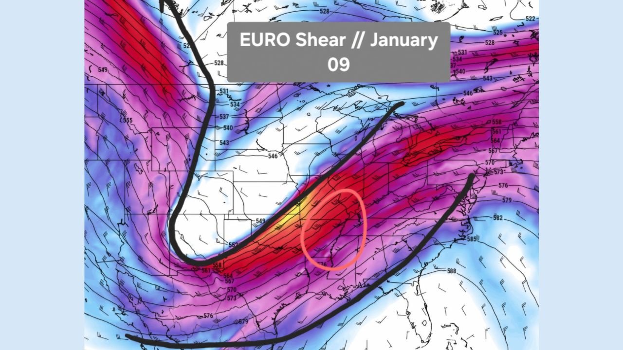
Strong Upper-Level Wind Shear Sets the Stage
Model data highlights a pronounced corridor of strong wind shear arcing from Texas through Louisiana, Mississippi, Arkansas, and into the lower Ohio Valley. The EURO shear maps show a powerful jet streak aligned southwest-to-northeast, a classic configuration that can support rotating storms if sufficient surface-based instability develops.
This shear environment alone is capable of supporting severe thunderstorms, including damaging wind gusts or brief tornadoes, if storms can fully organize.
Drier Air Intrusion May Limit Storm Coverage
One key limiting factor shown in the data is a notable intrusion of drier mid-level air pushing eastward ahead of the system. This dry air works against storm development by disrupting updraft strength and storm longevity, especially across parts of Arkansas, northern Mississippi, and western Tennessee.
Because of this, the threat appears more scattered and localized, rather than a large outbreak scenario.
Moisture Return Focused Near the Gulf Coast
EURO moisture-return maps show better low-level moisture pooling closer to the Gulf, particularly across southern Louisiana, coastal Mississippi, southern Alabama, and the Florida Panhandle. This zone has the highest potential for storms to briefly intensify, especially where moisture overlaps with peak wind shear.
However, even in these areas, instability values remain modest, which keeps the severe risk conditional rather than guaranteed.
CAPE Values Support Only Isolated Severe Storms
GFS CAPE output confirms the concern: instability remains limited, with only narrow pockets of marginal CAPE extending north from the Gulf Coast into the Lower Mississippi Valley. This supports the idea that any severe storms that form will be isolated, rather than widespread or long-lived.
The most likely impacts include:
- Localized damaging wind gusts
- Brief, isolated tornado potential
- Heavy downpours with stronger cells
Highest-Risk Areas Based on Current Data
Based strictly on the overlapping shear, moisture, and instability signals, the most favored corridor for isolated severe storms includes:
- Louisiana
- Mississippi
- Southern Arkansas
- Western Tennessee
- Southern Alabama
Areas farther north into the Ohio Valley show strong wind shear but insufficient instability, lowering severe potential there.
Bottom Line
This is not a high-end outbreak setup, but it is not a zero-risk day either. The atmospheric ingredients suggest isolated severe storms are possible, especially closer to the Gulf Coast where moisture is deepest. Small shifts in moisture or instability over the next few days could either enhance or further suppress the threat.
Residents across the central Gulf Coast and Mississippi Valley should stay weather-aware as forecasts are refined.
What’s your take on this setup — do you think the instability increases, or does dry air shut it down completely? Share your thoughts and stay tuned for more regional weather breakdowns at ChicagoMusicGuide.com.