
Hawaii Faces Dangerous Kona Low as Heavy Snow, Ice, and Flooding Threaten Big Island Summits
HAWAII — A powerful kona low weather system is impacting the Hawaiian Islands, drawing deep tropical moisture from the south and creating dangerous winter weather conditions, especially across the Big Island of Hawaii. According to the data, this system is capable of producing heavy snow, ice accumulation, flash flooding, and isolated thunderstorms, a rare but serious combination for the state.
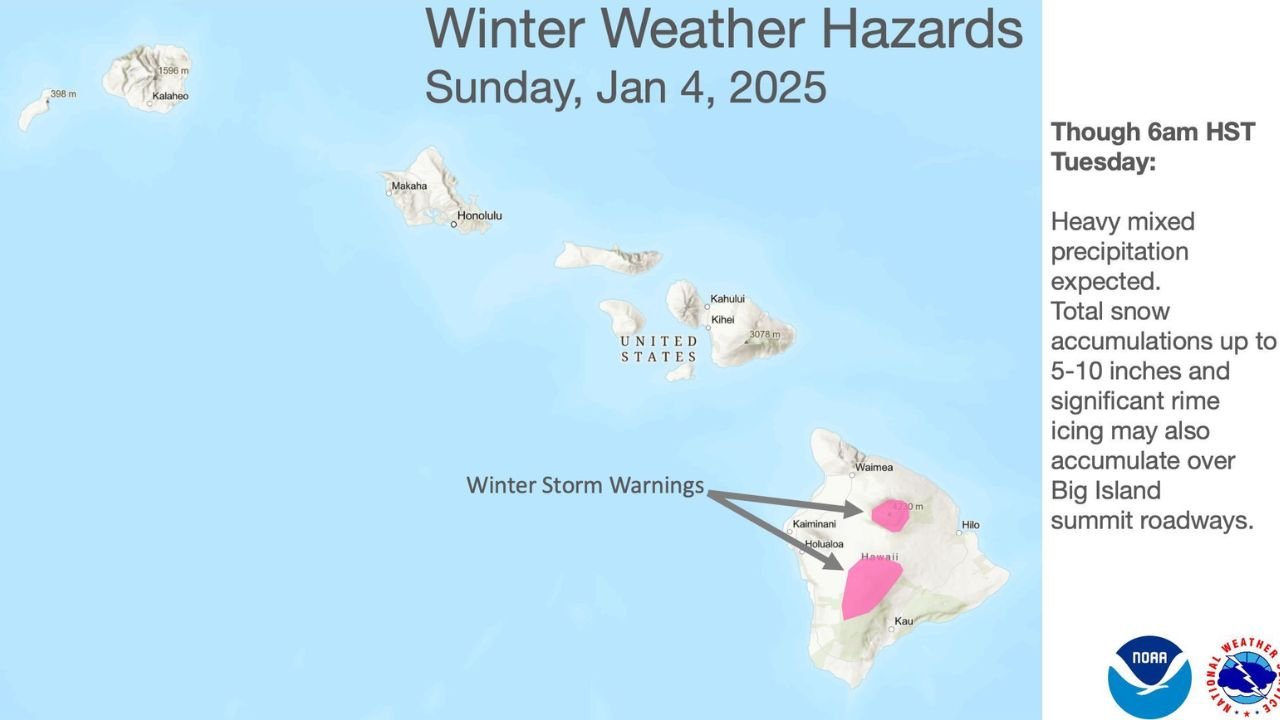
What the Data Shows Right Now
Meteorological data indicates that a cold-core kona low has developed southwest of the Hawaiian Islands. This system is pulling warm, moisture-rich air northward, forcing it to rise over the islands’ terrain. When this moisture interacts with colder air aloft, it results in intense precipitation — rain at lower elevations and snow and ice at higher elevations.
The system is expected to weaken slowly southwest of the islands from Tuesday into mid-week, but impacts will continue during this period.
Heavy Snow and Ice Target Mauna Kea and Mauna Loa
The highest risk zone is over the summits of Mauna Kea and Mauna Loa, where:
- Heavy snow accumulations of 5 to 10 inches are possible
- Significant rime ice may form due to freezing fog and strong winds
- Summit roadways may become impassable or extremely dangerous
- Visibility can rapidly drop to near zero during heavier bursts
These conditions are highly unusual for Hawaii but are well-documented effects of kona lows during winter months.
Flooding and Thunderstorm Risk at Lower Elevations
At lower elevations, the same moisture feed is expected to fall as heavy rain, increasing the risk of:
- Flash flooding in flood-prone and leeward areas
- Rapid runoff from steep terrain
- Isolated strong thunderstorms, including brief gusty winds
Unlike trade-wind systems, kona lows direct rainfall into areas that are normally drier, making flooding more dangerous due to limited drainage preparedness.
Why Kona Lows Are Especially Dangerous for Hawaii
A kona low is a seasonal subtropical cyclone that typically forms during the winter. The term kona means “leeward” in Hawaiian, referencing the side of the islands that usually remains sheltered from rainfall.
However, during kona low events:
- Winds reverse direction, blowing from the south or southwest
- Moisture is pushed into normally dry regions
- Rainfall becomes slow-moving and persistent
- Winter storms can impact both tropical lowlands and alpine summits simultaneously
Most years see one or two kona lows, but when they intensify, impacts can be severe.
What Happens Next
Forecast guidance shows the kona low gradually weakening by mid-week, but hazardous conditions may persist until the system fully pulls away from the islands. Snow, ice, and heavy rain risks will diminish only as moisture transport shuts down.
Residents and visitors are urged to avoid summit travel, monitor local warnings, and remain alert for rapidly changing conditions, especially in flood-prone zones.
What do you think — is Hawaii seeing more extreme winter weather than in past years, or is this a reminder of how powerful kona lows can be? Share your thoughts and stay updated with the latest weather coverage.