
Hazardous Sleet and Freezing Rain Slam Washington D.C., Maryland, and Virginia as Roads Become Impassable Across the Mid-Atlantic
WASHINGTON, D.C. — Dangerous winter weather conditions are rapidly deteriorating across Washington D.C., Maryland, and Virginia, as persistent sleet and increasing freezing rain turn roads and sidewalks into hazardous, nearly impassable surfaces. As of 3:49 p.m. Sunday, transportation officials warned that travel conditions have worsened significantly, with roads becoming difficult to impassable across much of the region.
Relentless precipitation, combined with limited road treatment activity due to the timing and intensity of the storm, has resulted in snow- and sleet-packed roadways, even along designated snow emergency routes.
Persistent Sleet Creating Dangerous Road and Sidewalk Conditions
Meteorologists report waves of heavy sleet continuing across much of the D.C. metro area, contributing to extremely poor driving and walking conditions. Officials stressed that unless travel is absolutely necessary, residents should stay off the roads.
The continuous nature of the precipitation has prevented effective plowing and treatment. Even roads that have been cleared earlier are quickly becoming re-covered, with uneven layers of sleet and compacted snow creating traction hazards.
Numerous reports and images show vehicles stuck across the region, including snowplows, underscoring just how treacherous conditions have become.
Freezing Rain Expected to Increase Into the Evening
While sleet has remained the dominant precipitation type for much of the afternoon, freezing rain is expected to mix in more frequently over the next several hours. Observations indicate freezing rain is already dominant in southern Maryland, particularly in St. Mary’s County, and is spreading into southeastern suburbs of Washington.
Forecasters expect freezing rain to become more common around the Capital Beltway by approximately 5 p.m., with gradual expansion thereafter. There remains some uncertainty regarding how far northwest the freezing rain will advance, though current guidance suggests it may struggle to push much beyond the Interstate 95 corridor.
Limited Road Treatment and Sunday Timing Compounding Impacts
The combination of steady precipitation, Sunday traffic patterns, and delayed treatment has left many roads and sidewalks untouched. Officials noted that even treated surfaces remain prone to refreezing and ice buildup, particularly as temperatures hover near or below freezing.
Pedestrian conditions are equally dangerous, with sidewalks coated in sleet and ice, making falls and injuries increasingly likely.
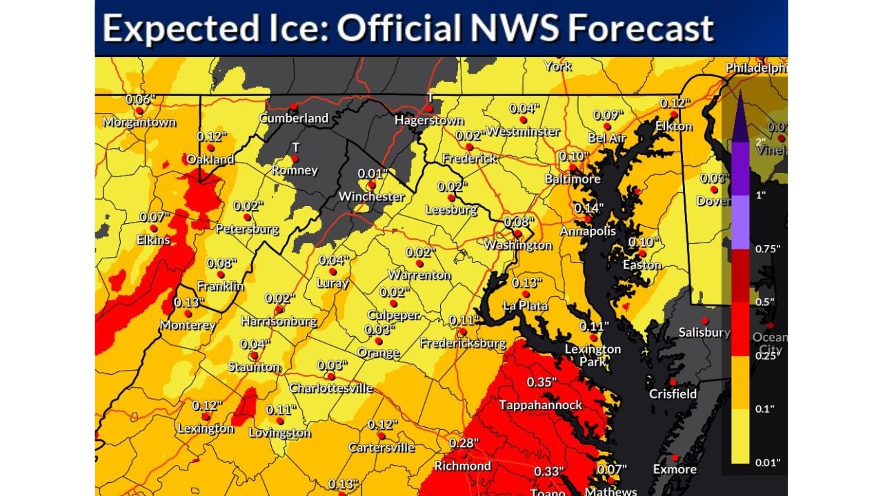
Ice Accumulation Expected to Remain Relatively Modest—but Dangerous
According to National Weather Service Baltimore/Washington forecasts, total freezing rain accumulations are expected to remain limited, generally up to one-tenth of an inch, mainly near Washington D.C. and Prince George’s County, Maryland.
Despite relatively light ice totals, officials caution that even minimal ice accretion is enough to cause major travel disruptions, especially when layered on top of sleet and compacted snow.
Road Conditions Likely to Remain Poor Into Monday
Transportation agencies warn that road conditions will remain a major mess at least until precipitation ends late Sunday evening, and more likely into Monday or beyond in some locations. Cleanup efforts may be slowed by continued freezing temperatures and lingering ice.
Residents are urged to delay travel, work remotely if possible, and allow crews time to safely address road conditions once precipitation tapers off.
What Residents Should Do Now
Officials across Washington D.C., Maryland, and Virginia recommend:
- Avoid all non-emergency travel
- Use extreme caution if walking outdoors
- Expect hazardous conditions during the Monday morning commute
- Monitor local alerts and updates closely
As winter weather continues to create dangerous conditions across the Mid-Atlantic, further updates will be issued as new data becomes available. For continued coverage, regional updates, and expert analysis on evolving weather impacts, stay with ChicagoMusicGuide.com.