
High-End Severe Weather Scenario Targets Dallas, Oklahoma City and Tulsa Under New SPC Hatching Intensity Outlook Concept
UNITED STATES — A newly illustrated severe weather outlook concept shows what a high-end event could look like under the Storm Prediction Center’s evolving hatching intensity forecast approach — and the map centers squarely on North Texas and eastern Oklahoma, including Dallas, McKinney, Plano, Oklahoma City and Tulsa.
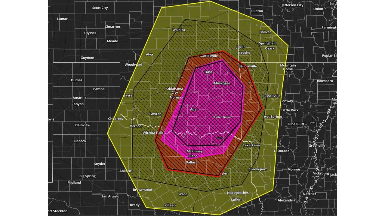
The example graphic demonstrates how future high-risk days may visually emphasize both coverage and intensity, with layered color zones representing escalating threat levels.
Core High-End Zone: Tulsa to Dallas Corridor
At the center of the map is a bold magenta-shaded and crosshatched area stretching from:
- Tulsa, Oklahoma
- Through Muskogee and Ada
- Down toward McKinney, Plano and Dallas, Texas
This zone represents the most intense potential threat area on a high-end severe day. The dense hatching suggests a combination of:
- Significant tornado potential
- Intense supercell structures
- Elevated risk to life and property
The concentration over major population centers underscores the seriousness such a setup would imply.
Expanded Significant Risk: Oklahoma City to Texarkana
Surrounding the core is a red and orange zone extending across:
- Oklahoma City and Norman
- Southward toward Wichita Falls
- East toward Texarkana
- North toward Bartlesville
This region reflects a broader area of organized severe storms capable of producing damaging winds, large hail and tornadoes.
Cities such as Oklahoma City and Dallas-Fort Worth sit within this expanded risk area, suggesting widespread severe weather potential beyond isolated supercells.
Outer Risk Envelope: Kansas to East Texas and Western Arkansas
A larger yellow-shaded polygon encompasses an even broader area including:
- Wichita, Kansas
- Springfield, Missouri
- Little Rock, Arkansas (western edge)
- Much of north and east Texas
This outer region indicates where severe storms could develop or track, depending on storm mode and atmospheric evolution.
It illustrates how high-end setups often feature a large geographic footprint, with varying intensity gradients.
What the New Hatching Concept Means
The updated visualization approach reflects a shift toward more nuanced communication of:
- Confidence levels
- Storm mode expectations (discrete supercells vs. clusters)
- Risk magnitude to populated areas
Instead of relying solely on categorical labels, the new style emphasizes where the most dangerous impacts are most likely concentrated.
Color intensity and hatching density may vary based on:
- Forecast confidence
- Tornado probability
- Potential for long-track storms
- Overall life and property risk
Why This Region Is Frequently Highlighted
The Dallas–Oklahoma City–Tulsa corridor lies within classic “Tornado Alley,” where:
- Gulf moisture surges northward
- Strong wind shear develops
- Dryline and frontal boundaries interact
When these ingredients overlap, the Southern Plains often become the focal point for significant outbreaks.
Bottom Line
This example outlook showcases how a future high-end severe day could be communicated, with the most intense focus over North Texas and eastern Oklahoma, including major metro areas like Dallas, Oklahoma City and Tulsa.
While this is an illustrative concept rather than a live forecast, it highlights how evolving risk communication may better define where the most dangerous storms are expected.
ChicagoMusicGuide.com will continue monitoring severe weather trends across the Plains and Midwest as spring storm season intensifies.