
I-80 Corridor from Princeton to Kankakee Targeted for Possible Strong Tornado Tuesday as Lake Breeze Lowers Risk Near Chicago
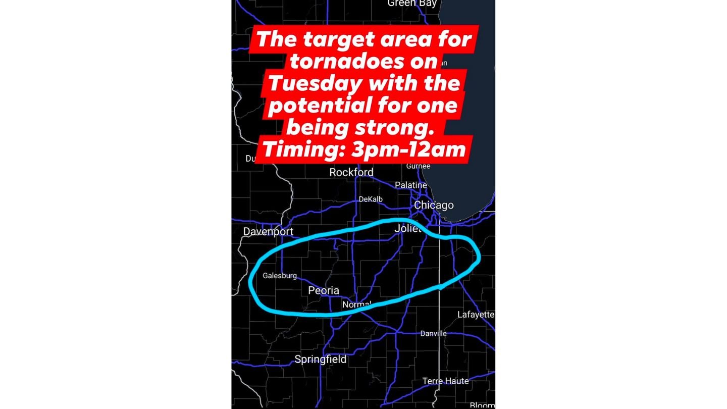
ILLINOIS — A focused tornado target area has been identified for Tuesday afternoon and evening across portions of central and north-central Illinois, particularly along the I-80 corridor from Princeton through Ottawa, Morris, Joliet, Streator, Kankakee, and Pontiac. Forecasters warn that several tornadoes may develop between 3 p.m. and midnight, with at least one potentially strong.
The tornado threat is expected to be lower closer to Lake Michigan, where a developing lake breeze could stabilize the air during the afternoon.
Primary Tornado Zone: Away from the Lake
The highlighted concern zone stretches west to east from near Princeton and Ottawa, through Morris and Joliet, and southeast toward Kankakee and Pontiac. This region lies far enough from Lake Michigan to avoid the stabilizing influence of cooler lake air.
Storms developing in this corridor could become surface-based during peak heating, increasing the potential for:
- Several tornadoes
- At least one strong tornado
- Large hail
- Damaging wind gusts
The most concerning timeframe is expected to begin shortly after lunchtime, intensifying into the late afternoon and evening hours.
Lake Breeze Could Reduce Tornado Risk Near Chicago
Closer to Chicago and the immediate lakeshore, tornado probabilities are currently lower due to the anticipated formation of a lake breeze boundary Tuesday afternoon. This boundary may push cooler air inland, disrupting storm structure and reducing tornado potential in lake-adjacent communities.
If the lake breeze strengthens or pushes farther inland than expected, the tornado threat could shift slightly southward. Conversely, if it remains weak, storms could extend closer to the Chicago metro with greater intensity.
For now, the highest concern remains away from the lake and along the I-80 corridor.
Timing: 3 p.m. Through Midnight
Forecast timing indicates storms may begin developing during the mid-afternoon, with the greatest tornado potential between 3 p.m. and 12 a.m. Some storms may continue into the late evening hours before weakening overnight.
Residents in:
- Princeton
- Ottawa
- Morris
- Joliet
- Streator
- Kankakee
- Pontiac
are advised to remain weather-aware beginning early Tuesday afternoon.
Strong Tornado Potential Cannot Be Ruled Out
While not every storm will produce a tornado, atmospheric conditions support rotating supercells in the highlighted corridor. If discrete storms develop and remain isolated before merging into clusters, the environment could support a strong tornado within the target zone.
Because the most favorable conditions exist south and west of the lake-cooled air, communities in central Illinois face a comparatively higher threat than immediate lakeshore areas.
Preparedness Recommended Before Lunch Tuesday
Forecasters emphasize that residents in the highlighted zone should not wait until storms are visible to prepare. Recommended actions include:
- Ensuring weather alerts are enabled
- Identifying safe shelter locations
- Monitoring updated forecast guidance Tuesday morning
The tornado target area may be refined again in the morning, but the current focus remains firmly centered on the I-80 corridor and surrounding central Illinois communities.
For continuing updates on Illinois tornado risk, Chicago-area storm timing, and severe weather alerts, visit ChicagoMusicGuide.com for the latest coverage as the situation evolves.